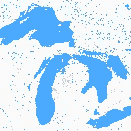
글로벌 내륙 수역 데이터 세트에는 담수호, 염수호, 강, 저수지 등 내륙 표면 수역이 표시됩니다.
GLS 2000 에포크에서 3,650,723km2의 내륙수가 확인되었으며, 이 중 약 4분의 3이 북미와 아시아에 있었습니다. 한대림과 툰드라에는 전 세계 총량의 약 40% 에 해당하는 가장 많은 내륙수가 있습니다. 이 데이터는 미국과 캐나다의 MODIS 데이터 세트 및 30m 해상도 데이터 세트와 강력한 선형 상관관계를 보입니다. 잔여 오류는 주로 수면, 눈, 얼음의 계절성과 잔여 구름으로 인해 발생했습니다.
데이터 세트에는 사용 가능한 Landsat WRS2 경로/행별로 하나 이상의 이미지가 포함되어 있습니다.
[null,null,[],[[["\u003cp\u003eThe Global Inland Water dataset identifies inland surface water bodies, including lakes, rivers, and reservoirs, primarily using Landsat imagery from the year 2000.\u003c/p\u003e\n"],["\u003cp\u003eApproximately 3,650,723 km² of inland water were identified globally, with a large concentration in North America and Asia, and boreal forests and tundra containing about 40% of the total.\u003c/p\u003e\n"],["\u003cp\u003eThis 30-meter resolution dataset classifies water bodies, land, snow/ice, and cloud cover, with detailed documentation and code examples provided for users.\u003c/p\u003e\n"],["\u003cp\u003eThe dataset is freely available for use with proper acknowledgment to the University of Maryland, Department of Geographical Sciences, and NASA.\u003c/p\u003e\n"],["\u003cp\u003eUsers can explore and analyze this dataset using Google Earth Engine, a platform for geospatial data analysis and visualization.\u003c/p\u003e\n"]]],[],null,["# GLCF: Landsat Global Inland Water\n\nDataset Availability\n: 2000-01-01T00:00:00Z--2000-12-31T00:00:00Z\n\nDataset Provider\n:\n\n\n [NASA LP DAAC at the USGS EROS Center](https://doi.org/10.5067/MEASURES/GFCC/GFCC30WC.001)\n\nTags\n:\n[glcf](/earth-engine/datasets/tags/glcf) [landsat-derived](/earth-engine/datasets/tags/landsat-derived) [nasa](/earth-engine/datasets/tags/nasa) [surface-ground-water](/earth-engine/datasets/tags/surface-ground-water) [umd](/earth-engine/datasets/tags/umd) [water](/earth-engine/datasets/tags/water) \n\n#### Description\n\nThe Global Inland Water dataset shows inland surface water bodies, including\nfresh and saline lakes, rivers, and reservoirs.\n\nFrom the GLS 2000 epoch, 3,650,723 km2 of inland water were identified,\naround three quarters of which were in North America and Asia. Boreal\nforests and tundra hold the largest portion of inland water, about 40% of\nthe global total. The data exhibits strong linear correlation with both the\nMODIS dataset as well as 30-m resolution datasets over the United States\nand Canada. Residual errors were due primarily to the seasonality of water\ncover, snow and ice, and residual clouds.\n\nThe dataset contains one or more image for each available Landsat WRS2\npath/row.\n\nDocumentation:\n\n- [User's guide](https://lpdaac.usgs.gov/documents/1371/GFCC_User_Guide_V1.pdf)\n\n- [Algorithm Theoretical Basis Document (ATBD)](https://lpdaac.usgs.gov/documents/1370/GFCC_ATBD.pdf)\n\n### Bands\n\n\n**Pixel Size**\n\n30 meters\n\n**Bands**\n\n| Name | Pixel Size | Description |\n|---------|------------|----------------------|\n| `water` | meters | Water classification |\n\n**water Class Table**\n\n| Value | Color | Description |\n|-------|---------|--------------|\n| 1 | #fafafa | Land |\n| 2 | #00c5ff | Water |\n| 4 | #df73ff | Snow/ice |\n| 200 | #828282 | Cloud shadow |\n| 201 | #cccccc | Cloud |\n\n### Image Properties\n\n**Image Properties**\n\n| Name | Type | Description |\n|---------------------|----------|---------------------|\n| path | DOUBLE | Path |\n| pathrow | STRING | Path and row |\n| row | DOUBLE | Row |\n| water_class_names | DOUBLE | Water class names |\n| water_class_palette | DOUBLE | Water class palette |\n| water_class_values | INT_LIST | Water class values |\n\n### Terms of Use\n\n**Terms of Use**\n\nIntellectual property rights to this dataset belong to University of\nMaryland, Department of Geographical Sciences and NASA. Usage is free if\nacklowedgement is made.\n\n### Citations\n\nCitations:\n\n- Data Citation: Global Inland Water, {Year, ...}, Global Land Cover\n Facility.\n- Paper/Methods Citation: Feng, Min, Joseph O. Sexton, Saurabh Channan,\n and John R. Townshend. 2015. [A Global, High-Resolution (30-M) Inland Water\n Body Dataset for 2000: First Results of a Topographic-Spectral\n Classification Algorithm](https://www.tandfonline.com/doi/pdf/10.1080/17538947.2015.1026420).\n International Journal of Digital Earth.\n [doi:10.1080/17538947.2015.1026420](https://doi.org/10.1080/17538947.2015.1026420).\n\n### DOIs\n\n- \u003chttps://doi.org/10.1080/17538947.2015.1026420\u003e\n\n### Explore with Earth Engine\n\n| **Important:** Earth Engine is a platform for petabyte-scale scientific analysis and visualization of geospatial datasets, both for public benefit and for business and government users. Earth Engine is free to use for research, education, and nonprofit use. To get started, please [register for Earth Engine access.](https://console.cloud.google.com/earth-engine)\n\n### Code Editor (JavaScript)\n\n```javascript\nvar dataset = ee.ImageCollection('GLCF/GLS_WATER');\nvar water = dataset.select('water');\nvar waterVis = {\n min: 1.0,\n max: 4.0,\n palette: ['fafafa', '00c5ff', 'df73ff', '828282', 'cccccc'],\n};\nMap.setCenter(-79.3094, 44.5693, 8);\nMap.addLayer(water, waterVis, 'Water');\n```\n[Open in Code Editor](https://code.earthengine.google.com/?scriptPath=Examples:Datasets/GLCF/GLCF_GLS_WATER) \n[GLCF: Landsat Global Inland Water](/earth-engine/datasets/catalog/GLCF_GLS_WATER) \nThe Global Inland Water dataset shows inland surface water bodies, including fresh and saline lakes, rivers, and reservoirs. From the GLS 2000 epoch, 3,650,723 km2 of inland water were identified, around three quarters of which were in North America and Asia. Boreal forests and tundra hold the largest portion of ... \nGLCF/GLS_WATER, glcf,landsat-derived,nasa,surface-ground-water,umd,water \n2000-01-01T00:00:00Z/2000-12-31T00:00:00Z \n-90 -180 90 180 \nGoogle Earth Engine \nhttps://developers.google.com/earth-engine/datasets\n\n- [https://doi.org/10.1080/17538947.2015.1026420](https://doi.org/https://doi.org/10.5067/MEASURES/GFCC/GFCC30WC.001)\n- [https://doi.org/10.1080/17538947.2015.1026420](https://doi.org/https://developers.google.com/earth-engine/datasets/catalog/GLCF_GLS_WATER)"]]