-
GLCF: Landsat 전 세계 내륙수
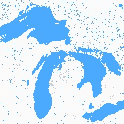
전 세계 내륙수 데이터 세트는 담수호와 염수호, 강, 저수지를 비롯한 내륙 지표수를 보여줍니다. GLS 2000 시대부터 3,650,723km²의 내륙수가 확인되었으며, 이 중 약 4분의 3이 북미와 아시아에 있었습니다. 한대림과 툰드라 … glcf landsat-derived nasa surface-ground-water umd water -
전 세계 산림 피복 변화 (GFCC) 다년도 전 세계 30m의 나무 피복
Landsat VCF (Vegetation Continuous Fields) 트리 캐노피 레이어에는 높이가 5m를 초과하는 목본 식물로 덮인 각 30m 픽셀의 수평 지면 비율 추정치가 포함되어 있습니다. 이 데이터 세트는 2000년, 2005년, 2010년을 중심으로 하는 4개의 시대에 사용할 수 있습니다. forest forest-biomass glcf landsat-derived nasa umd
Datasets tagged glcf in Earth Engine
[null,null,[],[],[]]