-
코트디부아르 BNETD 2020 토지 피복 지도
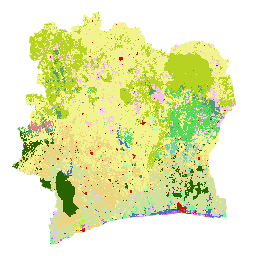
코트디부아르 BNETD 2020 토지 피복 지도는 코트디부아르 정부가 국가 기관인 국가 연구 사무소 기술 및 개발 센터 (BNETD-CIGN)를 통해 유럽 연합의 기술 및 재정적 지원을 받아 제작했습니다. 방법론 … 분류 삼림 파괴 숲 지표면 토지 이용 및 지표면 -
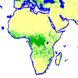
IPCC 지상 바이오매스 1단계 추정치를 위한 전 세계 2020년 산림 분류, V1

이 데이터 세트는 2020년의 상태/조건에 따라 구분된 전 세계 산림의 클래스를 약 30m 해상도로 제공합니다. 이 데이터는 2006년 IPCC 국가 온실가스 인벤토리 작성 지침의 2019년 개선사항에 따라 자연림의 지상 건조 목재 바이오매스 밀도 (AGBD)에 대한 1등급 추정치를 생성하는 데 지원됩니다. 지상 바이오매스 탄소 분류 산림 산림-바이오매스 -
전역 3등급 PALSAR-2/PALSAR 산림/비산림 지도
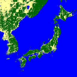
2017~2020년의 4개 클래스가 포함된 이 데이터 세트의 최신 버전은 JAXA/ALOS/PALSAR/YEARLY/FNF4에서 확인할 수 있습니다. 전 세계 산림/비산림 지도 (FNF)는 전 세계 25m 해상도 PALSAR-2/PALSAR SAR 모자이크에서 SAR 이미지 (후방 산란 계수)를 분류하여 생성되므로 강한 후방 산란 픽셀은 … alos alos2 classification eroc forest forest-biomass -
전역 4등급 PALSAR-2/PALSAR 산림/비산림 지도
전 세계 산림/비산림 지도 (FNF)는 전 세계 25m 해상도 PALSAR-2/PALSAR SAR 모자이크에서 SAR 이미지 (후방 산란 계수)를 분류하여 생성되며, 강한 후방 산란 픽셀과 약한 후방 산란 픽셀이 각각 '산림'과 '비산림'으로 할당됩니다. 여기서 '숲'은 …이 있는 자연 숲으로 정의됩니다. alos alos2 classification eroc forest forest-biomass
Datasets tagged classification in Earth Engine
[null,null,[],[],[]]