GFSAD는 21세기 글로벌 식량 안보에 기여하는 고해상도 글로벌 농경지 데이터와 물 사용량을 제공하기 위해 NASA의 지원을 받는 프로젝트입니다. GFSAD 제품은 다중 센서 원격 감지 데이터 (예: Landsat, MODIS, AVHRR), 보조 데이터, 필드 플롯 데이터를 사용하여 농경지 역학을 문서화하는 것을 목표로 합니다.
명목상 1km 규모에서 V0.1은 Thenkabail 외(2009a, 2011), Pittman 외(2010), Yu 외(2013), Friedl 외(2010)의 4가지 주요 연구에서 파생된 세분화된 5개 클래스 글로벌 농지 범위 지도의 공간 분포를 제공합니다. V1.0은 전 세계 경작지 면적과 관개 농업 대 천수답 농업에 관한 정보를 제공하는 5개 클래스 제품입니다. 작물 유형 또는 작물 유형 우세 정보가 없습니다. 시계열 원격 감지 데이터를 사용하여 모든 픽셀에 대해 자르기 강도 (단일, 이중, 삼중, 연속 자르기)를 얻을 수 있습니다. GFSAD1000 명목상 2010년 제품은 2007~2012년 데이터를 사용하여 생성되었습니다.
대역
픽셀 크기 1,000미터
대역
이름
최소
최대
픽셀 크기
설명
landcover
0
9
미터
마스크 클래스 설명 자르기
토지 피복 클래스 표
값
색상
설명
0
검은색
농경지 외
1
orange
경지: 관개 주요
2
갈색
경작지: 관개 경미
3
darkseagreen
경지: 강수
4
green
농지: 강수, 소규모 조각
5
노란색
농지: 강수량, 매우 작은 조각
이용약관
이용약관
대부분의 미국 지질조사국 (USGS) 정보는 퍼블릭 도메인에 있으며 제한 없이 사용할 수 있습니다. 정보 소스로 USGS를 인용 또는 표시에 관한 추가 정보를 확인할 수 있습니다.
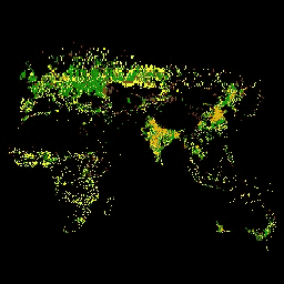
GFSAD는 21세기 글로벌 식량 안보에 기여하는 고해상도 글로벌 농지 데이터와 물 사용량을 제공하기 위해 NASA의 지원을 받는 프로젝트입니다. GFSAD 제품은 다중 센서 원격 감지 데이터 (예: Landsat, MODIS, AVHRR), 2차 데이터, 필드 플롯 데이터를 사용하여 농경지를 문서화하는 것을 목표로 합니다.
[null,null,[],[[["\u003cp\u003eGFSAD1000_V1 provides a global cropland extent map at a 1km resolution, classifying land as non-cropland, irrigated, or rainfed.\u003c/p\u003e\n"],["\u003cp\u003eThe dataset utilizes multi-sensor remote sensing data, secondary data, and field-plot data to document cropland dynamics.\u003c/p\u003e\n"],["\u003cp\u003eThis NASA-funded project aims to support global food security analysis by providing insights into cropland distribution and water use.\u003c/p\u003e\n"],["\u003cp\u003eThe GFSAD1000 product was created using data primarily from 2007 to 2012 and represents the nominal year 2010.\u003c/p\u003e\n"],["\u003cp\u003eUSGS provides this dataset with minimal restrictions, encouraging its use for research, education, and nonprofit purposes.\u003c/p\u003e\n"]]],["The Global Food Security-support Analysis Data (GFSAD) project provides a 1km-scale global cropland extent map (GFSAD1000_V1) for 2010, derived from multiple studies and remote sensing data (2007-2012). It classifies land into six categories, ranging from non-croplands to various types of irrigated and rainfed croplands. Users can access the data via Google Earth Engine, utilizing an `ee.Image` snippet. The data can be visualized with a color palette based on landcover classes, supporting studies on cropland dynamics and water use.\n"],null,["# GFSAD1000: Cropland Extent 1km Multi-Study Crop Mask, Global Food-Support Analysis Data\n\nDataset Availability\n: 2010-01-01T00:00:00Z--2010-01-01T00:00:00Z\n\nDataset Provider\n:\n\n\n [Global Food Security-support Analysis Data at 30m Project (GFSAD30)](https://geography.wr.usgs.gov/science/croplands/)\n\nTags\n:\n [agriculture](/earth-engine/datasets/tags/agriculture) [crop](/earth-engine/datasets/tags/crop) [landcover](/earth-engine/datasets/tags/landcover) [usgs](/earth-engine/datasets/tags/usgs) \ngfsad \n\n#### Description\n\nThe GFSAD is a NASA-funded project to provide high-resolution global\ncropland data and their water use that contributes towards global food\nsecurity in the twenty-first century. The GFSAD products are derived\nthrough multi-sensor remote sensing data (e.g., Landsat, MODIS, AVHRR),\nsecondary data, and field-plot data and aims at documenting cropland\ndynamics.\n\nAt a nominal 1km scale, V0.1 provides the spatial distribution of a\ndisaggregated five-class global cropland extent map derived from four\nmajor studies: Thenkabail et al. (2009a, 2011), Pittman et al. (2010),\nYu et al. (2013), and Friedl et al. (2010). V1.0 is a 5-class product that\nprovides information on global cropland extent and irrigated versus rainfed\ncropping. There is no crop type or crop type dominance information. Cropping\nintensity (single, double, triple, and continuous crops) can be obtained for\nevery pixel using time-series remote sensing data. The GFSAD1000 nominal\n2010 product was created with data from 2007 to 2012.\n\n### Bands\n\n\n**Pixel Size**\n\n1000 meters\n\n**Bands**\n\n| Name | Min | Max | Pixel Size | Description |\n|-------------|-----|-----|------------|------------------------------|\n| `landcover` | 0 | 9 | meters | Crop mask class descriptions |\n\n**landcover Class Table**\n\n| Value | Color | Description |\n|-------|--------------|------------------------------------------|\n| 0 | black | Non-croplands |\n| 1 | orange | Croplands: irrigation major |\n| 2 | brown | Croplands: irrigation minor |\n| 3 | darkseagreen | Croplands: rainfed |\n| 4 | green | Croplands: rainfed, minor fragments |\n| 5 | yellow | Croplands: rainfed, very minor fragments |\n\n### Terms of Use\n\n**Terms of Use**\n\nMost U.S. Geological Survey (USGS) information resides\nin the public domain and may be used without restriction. Additional\ninformation on [Acknowledging or Crediting USGS as Information\nSource](https://www.usgs.gov/information-policies-and-instructions/acknowledging-or-crediting-usgs)\nis available.\n\n### Citations\n\nCitations:\n\n- [Teluguntla, P., Thenkabail, P.S., Xiong, J., Gumma, M.K., Giri, C., Milesi,\n C., Ozdogan, M., Congalton, R., Tilton, J., Sankey, T.R., Massey, R.,\n Phalke, A., and Yadav, K. 2014. Global Cropland Area Database (GCAD)\n derived from Remote Sensing in Support of Food Security in the Twenty-first\n Century: Current Achievements and Future Possibilities. Chapter 7, Vol. II.\n Land Resources: Monitoring, Modelling, and Mapping, Remote Sensing Handbook\n edited by Prasad S. Thenkabail. In Press.](https://lpdaac.usgs.gov/documents/173/GFSAD1K_ATBD.pdf)\n\n### Explore with Earth Engine\n\n| **Important:** Earth Engine is a platform for petabyte-scale scientific analysis and visualization of geospatial datasets, both for public benefit and for business and government users. Earth Engine is free to use for research, education, and nonprofit use. To get started, please [register for Earth Engine access.](https://console.cloud.google.com/earth-engine)\n\n### Code Editor (JavaScript)\n\n```javascript\nvar dataset = ee.Image('USGS/GFSAD1000_V1');\nvar cropMask = dataset.select('landcover');\nvar cropMaskVis = {\n min: 0.0,\n max: 5.0,\n palette: ['black', 'orange', 'brown', '02a50f', 'green', 'yellow'],\n};\nMap.setCenter(-17.22, 13.72, 2);\nMap.addLayer(cropMask, cropMaskVis, 'Crop Mask');\n```\n[Open in Code Editor](https://code.earthengine.google.com/?scriptPath=Examples:Datasets/USGS/USGS_GFSAD1000_V1) \n[GFSAD1000: Cropland Extent 1km Multi-Study Crop Mask, Global Food-Support Analysis Data](/earth-engine/datasets/catalog/USGS_GFSAD1000_V1) \nThe GFSAD is a NASA-funded project to provide high-resolution global cropland data and their water use that contributes towards global food security in the twenty-first century. The GFSAD products are derived through multi-sensor remote sensing data (e.g., Landsat, MODIS, AVHRR), secondary data, and field-plot data and aims at documenting cropland ... \nUSGS/GFSAD1000_V1, agriculture,crop,landcover,usgs \n2010-01-01T00:00:00Z/2010-01-01T00:00:00Z \n-90 -180 90 180 \nGoogle Earth Engine \nhttps://developers.google.com/earth-engine/datasets\n\n- [](https://doi.org/https://geography.wr.usgs.gov/science/croplands/)\n- [](https://doi.org/https://developers.google.com/earth-engine/datasets/catalog/USGS_GFSAD1000_V1)"]]