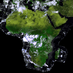
Proba-V to misja satelitarna, której celem jest mapowanie pokrywy terenu i wzrostu roślinności. Został zaprojektowany z myślą o zapewnieniu ciągłości działania instrumentu optycznego VGT
z misji SPOT-4 i SPOT-5.
Czujnik zbiera dane w 3 pasmach VNIR (widzialnych i bliskiej podczerwieni) i 1 paśmie spektralnym SWIR (krótkofalowej podczerwieni) o polu widzenia 2250 km. Zdjęcia globalne są tworzone co 2 dni w rozdzielczości 300 m, a zdjęcia o rozdzielczości 100 m z obserwacji w punkcie nadiru – co 5 dni. Te obrazy są później łączone, aby utworzyć ten dzienny zbiór danych syntetycznych. Opis procedur kompozycji i korekcji atmosferycznej znajdziesz w podręczniku użytkownika.
Wartości odbicia podane w tym zbiorze danych są przedstawione jako liczby cyfrowe (DN) i muszą zostać przekonwertowane zgodnie z wytycznymi w sekcji 4.6.1 instrukcji obsługi.
Pasma
Rozmiar piksela 100 metrów
Pasma
Nazwa
Jednostki
Rozmiar piksela
Długość fali
Opis
RED
metry
658 nm, FWHM: 82 nm
Odbicie od wierzchołków drzew – kanał CZERWONY
NIR
metry
834 nm, FWHM: 121 nm
Kanał NIR odbicia w górnej części korony drzewa
BLUE
metry
460 nm, FWHM: 42 nm
Odbicie od wierzchołków drzew w kanale NIEBIESKIM
SWIR
metry
1610 nm, FWHM: 89 nm
Odbicie od wierzchołków drzew w kanale SWIR
NDVI
metry
Brak
Znormalizowany różnicowy wskaźnik wegetacji
SZA
deg
metry
Brak
Kąt zenitu słonecznego
SAA
deg
metry
Brak
Słoneczny kąt azymutu
SWIRVAA
deg
metry
Brak
Kąty azymutu obserwacji detektora SWIR
SWIRVZA
deg
metry
Brak
Detektor SWIR kąta zenitalnego
VNIRVAA
deg
metry
Brak
Kąt azymutu obserwacji detektora VNIR
VNIRVZA
deg
metry
Brak
Kąt zenitalny detektora VNIR
SM
metry
Brak
Jakość / pasmo informacji.
Bitmask for SM
Bity 0–2: flaga chmury/lodu/cienia
0: Wyczyść
1: Cień
2: Nie określono
3. Cloud
4. Ice
Bit 3. Ląd/morze
0: Morze
1. Ląd (piksele o tej wartości mogą obejmować obszary morskie)
Bit 4: flaga jakości radiometrycznej SWIR
0: Zły
1. Dobry
Bit 5: Flaga jakości radiometrycznej NIR
0: Zły
1. Dobry
Bit 6: Radiometric quality RED flag
0: Zły
1. Dobry
Bit 7: Radiometric quality BLUE flag
0: Zły
1. Dobry
TIME
min
metry
Brak
Czas, który upłynął od rozpoczęcia zbierania obrazów do utworzenia tej mozaiki.
Właściwości obrazu
Właściwości obrazu
Nazwa
Typ
Opis
ARCHIVING_DATE
CIĄG ZNAKÓW
Data archiwizacji
CLOUD_COVER_PERCENTAGE
LICZBA ZMIENNOPRZECINKOWA O PODWÓJNEJ PRECYZJI
Procent zachmurzenia
LAND_PERCENTAGE
LICZBA ZMIENNOPRZECINKOWA O PODWÓJNEJ PRECYZJI
Odsetek powierzchni lądowej
MISSING_DATA_PERCENTAGE
LICZBA ZMIENNOPRZECINKOWA O PODWÓJNEJ PRECYZJI
Odsetek brakujących danych
PROBAV_ATMCORR_SMAC_VERSION
CIĄG ZNAKÓW
Wstępna wersja algorytmu korekcji atmosferycznej
PROBAV_CLOUDICESNOWDETECTION_VERSION
CIĄG ZNAKÓW
Pierwsza wersja algorytmu wykrywania chmur i śniegu/lodu
PROBAV_COMPOSITING_MVC_VERSION
CIĄG ZNAKÓW
Wstępna wersja algorytmu kompozycji MVC
PROBAV_GEOMODELLING_VERSION
CIĄG ZNAKÓW
Wstępna wersja algorytmu modelowania geometrycznego
PROBAV_MAPPING_VERSION
CIĄG ZNAKÓW
Wstępna wersja algorytmu prognozowania
PROBAV_MOSAIC_VERSION
CIĄG ZNAKÓW
Wstępna wersja algorytmu mozaikowania
PROBAV_RADIOMODELLING_VERSION
CIĄG ZNAKÓW
Pierwsza wersja algorytmu modelowania radiometrycznego
PROBAV_SHADOWDETECTION_VERSION
CIĄG ZNAKÓW
Pierwsza wersja algorytmu wykrywania cieni
PRODUCT_VERSION
CIĄG ZNAKÓW
Wersja usługi
SNOW_COVER_PERCENTAGE
LICZBA ZMIENNOPRZECINKOWA O PODWÓJNEJ PRECYZJI
Procent pokrycia śniegiem
Warunki korzystania z usługi
Dane PROBA-V o rozdzielczości 300 m i 100 m są dostępne bezpłatnie, jeśli mają więcej niż miesiąc.
Proba-V to misja satelitarna, której celem jest mapowanie pokrycia terenu i wzrostu roślinności. Został on zaprojektowany tak, aby zapewnić ciągłość działania instrumentu optycznego VGT z misji SPOT-4 i SPOT-5. Czujnik zbiera dane w 3 pasmach VNIR (widzialnych i bliskiej podczerwieni) oraz w 1 pasmo spektralne SWIR (krótkofalowej podczerwieni) o …
[null,null,[],[[["\u003cp\u003eProba-V mission maps land cover and vegetation growth, providing continuity for the VGT instrument from SPOT missions.\u003c/p\u003e\n"],["\u003cp\u003eThe dataset offers daily top-of-canopy reflectance composites at 100m resolution, derived from nadir observations every 5 days.\u003c/p\u003e\n"],["\u003cp\u003eReflectances are presented as Digital Count Numbers (DN) and need conversion according to the user manual.\u003c/p\u003e\n"],["\u003cp\u003eBands include Red, NIR, Blue, SWIR, along with derived indices (NDVI), solar/viewing angles, and a quality/information band.\u003c/p\u003e\n"],["\u003cp\u003eData older than one month is freely and openly available.\u003c/p\u003e\n"]]],["The dataset from the Proba-V satellite mission, available from 2013-10-17 to 2021-10-31, provides daily, 100-meter resolution land cover and vegetation data. The sensor captures three VNIR bands and one SWIR band, which are synthesized daily from images taken globally every two days. Users must convert provided reflectance Digital Count Numbers (DN) using the linked user manual. The dataset is accessible via Earth Engine with a specific snippet provided. The data is freely available for use in non profit, education, and research.\n"],null,["# PROBA-V C1 Top Of Canopy Daily Synthesis 100m\n\nDataset Availability\n: 2013-10-17T00:00:00Z--2021-10-31T00:00:00Z\n\nDataset Provider\n:\n\n\n [Vito / ESA](https://proba-v.vgt.vito.be/)\n\nCadence\n: 1 Day\n\nTags\n:\n[esa](/earth-engine/datasets/tags/esa) [multispectral](/earth-engine/datasets/tags/multispectral) [nir](/earth-engine/datasets/tags/nir) [proba](/earth-engine/datasets/tags/proba) [probav](/earth-engine/datasets/tags/probav) [satellite-imagery](/earth-engine/datasets/tags/satellite-imagery) [swir](/earth-engine/datasets/tags/swir) [vito](/earth-engine/datasets/tags/vito) \n\n#### Description\n\nProba-V is a satellite mission tasked to map land cover and vegetation\ngrowth. It was designed to provide continuity for the VGT optical instrument\nfrom the SPOT-4 and SPOT-5 missions.\n\nThe sensor collects data in three VNIR (visible and near-infrared) bands\nand one SWIR (short-wave infrared) spectral band with a 2250km field of\nview. Global images are produced every 2 days at 300m resolution, and a 100m\nimage from nadir observations every 5 days. These images are later\ncomposited to produce this daily synthesis dataset. The description of\nthe compositing and atmospheric correction procedures can be found in\nthe [user manual](https://publications.vito.be/2017-1333-probav-products-user-manual.pdf).\n\nThe reflectances provided in this dataset are presented as Digital Count\nNumbers (DN) and must be converted according to the guidelines in\nSection 4.6.1 of the [user manual](https://publications.vito.be/2017-1333-probav-products-user-manual.pdf).\n\n### Bands\n\n\n**Pixel Size**\n\n100 meters\n\n**Bands**\n\n| Name | Units | Pixel Size | Wavelength | Description |\n|-----------|-------|------------|--------------------|-----------------------------------------------------------------|---|---|---|---|---|---|---|---|---|---|---|---|---|---|---|---|---|---|---|---|---|---|---|---|---|---|---|---|---|---|---|---|---|---|---|---|---|---|---|---|---|---|---|---|---|---|---|---|---|---|---|---|---|---|---|---|---|---|---|---|---|---|---|---|---|---|---|---|---|---|---|---|---|---|---|---|---|---|---|---|---|---|---|---|---|---|---|---|---|---|---|---|---|---|---|\n| `RED` | | meters | 658nm, FWHM: 82nm | Top of canopy reflectance RED channel |\n| `NIR` | | meters | 834nm, FWHM: 121nm | Top of canopy reflectance NIR channel |\n| `BLUE` | | meters | 460nm, FWHM: 42nm | Top of canopy reflectance BLUE channel |\n| `SWIR` | | meters | 1610nm, FWHM: 89nm | Top of canopy reflectance SWIR channel |\n| `NDVI` | | meters | None | Normalized Difference Vegetation Index |\n| `SZA` | deg | meters | None | Solar zenith angle |\n| `SAA` | deg | meters | None | Solar azimuth angle |\n| `SWIRVAA` | deg | meters | None | Viewing azimuth angles SWIR detector |\n| `SWIRVZA` | deg | meters | None | Viewing zenith angle SWIR detector |\n| `VNIRVAA` | deg | meters | None | Viewing azimuth angle VNIR detector |\n| `VNIRVZA` | deg | meters | None | Viewing zenith angle VNIR detector |\n| `SM` | | meters | None | Quality / Information band. |\n| Bitmask for SM - Bits 0-2: Cloud/ice snow/shadow flag - 0: Clear - 1: Shadow - 2: Undefined - 3: Cloud - 4: Ice - Bit 3: Land/sea - 0: Sea - 1: Land (pixels with this value may include areas of sea) - Bit 4: Radiometric quality SWIR flag - 0: Bad - 1: Good - Bit 5: Radiometric quality NIR flag - 0: Bad - 1: Good - Bit 6: Radiometric quality RED flag - 0: Bad - 1: Good - Bit 7: Radiometric quality BLUE flag - 0: Bad - 1: Good ||||||||||||||||||||||||||||||||||||||||||||||||||||||||||||||||||||||||||||||||||||||||||||||||||||\n| `TIME` | min | meters | None | Time elapsed since the start of image collection of this mosaic |\n\n### Image Properties\n\n**Image Properties**\n\n| Name | Type | Description |\n|--------------------------------------|--------|---------------------------------------------------------------|\n| ARCHIVING_DATE | STRING | Archiving date |\n| CLOUD_COVER_PERCENTAGE | DOUBLE | Cloud cover percentage |\n| LAND_PERCENTAGE | DOUBLE | Land percentage |\n| MISSING_DATA_PERCENTAGE | DOUBLE | Missing data percentage |\n| PROBAV_ATMCORR_SMAC_VERSION | STRING | Initial version of the atmospheric correction algorithm |\n| PROBAV_CLOUDICESNOWDETECTION_VERSION | STRING | Initial version of the cloud and snow/ice detection algorithm |\n| PROBAV_COMPOSITING_MVC_VERSION | STRING | Initial version of the MVC compositing algorithm |\n| PROBAV_GEOMODELLING_VERSION | STRING | Initial version of the geometric modelling algorithm |\n| PROBAV_MAPPING_VERSION | STRING | Initial version of the projection algorithm |\n| PROBAV_MOSAIC_VERSION | STRING | Initial version of the mosaicking algorithm |\n| PROBAV_RADIOMODELLING_VERSION | STRING | Initial version of the radiometric modelling algorithm |\n| PROBAV_SHADOWDETECTION_VERSION | STRING | Initial version of the shadow detection algorithm |\n| PRODUCT_VERSION | STRING | Product version |\n| SNOW_COVER_PERCENTAGE | DOUBLE | Snow cover percentage |\n\n### Terms of Use\n\n**Terms of Use**\n\nPROBA-V 300m and 100m data are freely available for data older than 1 month.\n\n### Citations\n\nCitations:\n\n- Copyright ESA-BELSPO, produced by Vito\n\n### Explore with Earth Engine\n\n| **Important:** Earth Engine is a platform for petabyte-scale scientific analysis and visualization of geospatial datasets, both for public benefit and for business and government users. Earth Engine is free to use for research, education, and nonprofit use. To get started, please [register for Earth Engine access.](https://console.cloud.google.com/earth-engine)\n\n### Code Editor (JavaScript)\n\n```javascript\nvar dataset = ee.ImageCollection('VITO/PROBAV/C1/S1_TOC_100M')\n .filter(ee.Filter.date('2018-03-01', '2018-04-01'));\nvar falseColor = dataset.select(['RED', 'NIR', 'BLUE']);\nvar falseColorVis = {\n min: 20.0,\n max: 2000.0,\n};\nMap.setCenter(17.93, 7.71, 2);\nMap.addLayer(falseColor, falseColorVis, 'False Color');\n```\n[Open in Code Editor](https://code.earthengine.google.com/?scriptPath=Examples:Datasets/VITO/VITO_PROBAV_C1_S1_TOC_100M) \n[PROBA-V C1 Top Of Canopy Daily Synthesis 100m](/earth-engine/datasets/catalog/VITO_PROBAV_C1_S1_TOC_100M) \nProba-V is a satellite mission tasked to map land cover and vegetation growth. It was designed to provide continuity for the VGT optical instrument from the SPOT-4 and SPOT-5 missions. The sensor collects data in three VNIR (visible and near-infrared) bands and one SWIR (short-wave infrared) spectral band with a ... \nVITO/PROBAV/C1/S1_TOC_100M, esa,multispectral,nir,proba,probav,satellite-imagery,swir,vito \n2013-10-17T00:00:00Z/2021-10-31T00:00:00Z \n-90 -180 90 180 \nGoogle Earth Engine \nhttps://developers.google.com/earth-engine/datasets\n\n- [](https://doi.org/https://proba-v.vgt.vito.be/)\n- [](https://doi.org/https://developers.google.com/earth-engine/datasets/catalog/VITO_PROBAV_C1_S1_TOC_100M)"]]