-
Zbiór danych dotyczących zdjęć lasów w Brazylii w 2008 roku: analityczna mapa podstawowa

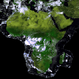
Ten zbiór danych zawiera wielospektralną (zieloną, czerwoną i bliską podczerwieni) mapę podstawową Brazylii o rozdzielczości do 10 m, która została utworzona głównie w 2008 r. i ma wspierać wdrażanie brazylijskiego kodeksu leśnego. Mozaika jest tworzona na podstawie danych satelitarnych SPOT 2, 4 i 5. Jest to obraz o wyższej rozdzielczości… brazil forest-code google imagery multispectral satellite-imagery -
PROBA-V C1 Top Of Canopy Daily Synthesis 100m
Proba-V to misja satelitarna, której celem jest mapowanie pokrycia terenu i wzrostu roślinności. Został on zaprojektowany tak, aby zapewnić ciągłość działania instrumentu optycznego VGT z misji SPOT-4 i SPOT-5. Czujnik zbiera dane w 3 pasmach VNIR (widzialnych i bliskiej podczerwieni) oraz w 1 paśmie SWIR (krótkofalowej podczerwieni). esa multispectral nir proba probav zdjęcia-satelitarne -
PROBA-V C1 Top Of Canopy Daily Synthesis 333m

Proba-V to misja satelitarna, której celem jest mapowanie pokrycia terenu i wzrostu roślinności. Został on zaprojektowany tak, aby zapewnić ciągłość działania instrumentu optycznego VGT z misji SPOT-4 i SPOT-5. Czujnik zbiera dane w 3 pasmach VNIR (widzialnych i bliskiej podczerwieni) oraz w 1 paśmie SWIR (krótkofalowej podczerwieni). esa multispectral nir proba probav zdjęcia-satelitarne -
Planet SkySat Public Ortho Imagery, Multispectral
Te dane z satelitów SkySat firmy Planet Labs Inc. zostały zebrane w 2015 r. na potrzeby eksperymentalnego programu „Skybox for Good Beta”, a także w ramach różnych działań związanych z reagowaniem na sytuacje kryzysowe i kilku innych projektów. Dane są dostępne w zbiorze wielospektralnym/panchromatycznym w 5 pasmach oraz w … highres multispectral pansharpened planet satellite-imagery skysat -
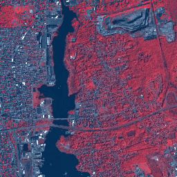
Zdjęcia multispektralne SPOT o rozdzielczości 10–20 m, Brazylia

Ta kolekcja zawiera surowe zdjęcia wielospektralne z 2008 roku z satelitów SPOT 2, 4 i 5 nad Brazylią. Te misje, prowadzone przez CNES, miały na celu dostarczanie zdjęć optycznych w wysokiej rozdzielczości i na dużym obszarze, które służą do zarządzania zasobami Ziemi. SPOT 2 i 4 wykorzystywały HRV i HRVIR… brazil forest-code google multispectral satellite-imagery spot
Datasets tagged multispectral in Earth Engine
[null,null,[],[],[]]