WRI থেকে নোট : WRI ফর্মা সতর্কতা আপডেট করা বন্ধ করার সিদ্ধান্ত নিয়েছে। লক্ষ্য ছিল গ্লোবাল ফরেস্ট ওয়াচ ব্যবহারকারীর অভিজ্ঞতা সহজ করা এবং অপ্রয়োজনীয়তা হ্রাস করা। আমরা খুঁজে পেয়েছি যে Terra-i এবং GLAD বেশি ব্যবহার করা হয়েছে। অধিকন্তু, GLAD কে একটি স্ট্যান্ডার্ড হিসাবে ব্যবহার করে দেখা গেছে যে Terra-i বিশ্বব্যাপী ফর্মাকে ছাড়িয়ে গেছে।
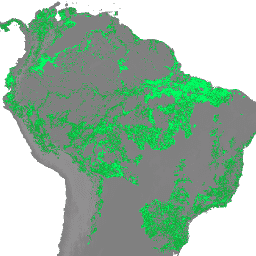
FORMA সতর্কতা দুটি MODIS পণ্যের সংমিশ্রণ ব্যবহার করে সনাক্ত করা হয়: NDVI (নর্মালাইজড ডিফারেন্স ভেজিটেশন ইনডেক্স) এবং FIRMS (রিসোর্স ম্যানেজমেন্ট সিস্টেমের জন্য আগুনের তথ্য)। NDVI আপডেটগুলি প্রতি 16 দিনে প্রক্রিয়া করা হয়, যখন ফায়ার আপডেটগুলি প্রতিদিন প্রক্রিয়া করা হয়। মডেলগুলিকে প্রশিক্ষণের জন্য হ্যানসেনের বার্ষিক ট্রি কভার লস ডেটা ব্যবহার করে ক্লিয়ারিংয়ের ক্ষেত্রে দুটি ইনপুটকে সংযুক্ত করার জন্য প্রতিটি ইকোগ্রুপের জন্য পৃথকভাবে মডেলগুলি তৈরি করা হয়। সতর্কতা হিসাবে যোগ্যতা অর্জনের জন্য ন্যূনতম থ্রেশহোল্ড হল 25% পিক্সেল সাফ করা হয়েছে, যদিও থ্রেশহোল্ডগুলি ইকোগ্রুপ অনুসারে পরিবর্তিত হয় যাতে মিথ্যা পজিটিভগুলি কম হয়৷ FORMA ডেটাসেটের দ্রুত পরিচিতির জন্য এখানে একটি উদাহরণ স্ক্রিপ্ট ।
এই ইমেজ কালেকশনের ছবিগুলিতে প্রায় প্রতিদিন নতুন MODIS FIRMS ডেটা উপলব্ধ হওয়ার পরে গণনা করা কাঁচা ফর্মা ডেটা রয়েছে৷
প্রতিটি ব্যান্ড বিভিন্ন জমা সময়কালের জন্য ক্লিয়ারিং শতাংশ (0 থেকে 100 পর্যন্ত) দেয়। "N" হল সাম্প্রতিক FIRMS আপডেট এবং পূর্ববর্তী NDVI আপডেটের মধ্যে দিনের সংখ্যা। N 'তারিখ_ডেল্টা' বৈশিষ্ট্য দ্বারা প্রদত্ত।
ব্যান্ড
পিক্সেল সাইজ 250 মিটার
ব্যান্ড
নাম
ইউনিট
মিন
সর্বোচ্চ
পিক্সেল সাইজ
বর্ণনা
nday
%
0
100
মিটার
গত N দিনে ক্লিয়ারিংয়ের শতাংশ
delta_nday
%
0
100
মিটার
গত 96+N দিনে ক্লিয়ারিংয়ের শতাংশ
near_term_delta_nday
%
0
100
মিটার
গত 32+N দিনে ক্লিয়ারিংয়ের শতাংশ
ইমেজ বৈশিষ্ট্য
ইমেজ বৈশিষ্ট্য
নাম
টাইপ
বর্ণনা
বছর
আইএনটি
ডেটাসেটে অন্তর্ভুক্ত সাম্প্রতিকতম ডেটার বছর৷
তারিখ
STRING
তারিখ, "YYYY-MM-DD" ফর্ম্যাটে, এই ডেটাসেটে অন্তর্ভুক্ত শেষ MODIS FIRMS ডেটার
date_delta
আইএনটি
তারিখ এবং আগের_সাপ্তাহিক_তারিখের মধ্যে দিনের সংখ্যা
আগের_সাপ্তাহিক
আইএনটি
সাম্প্রতিক MODIS NDVI-এর সাথে যুক্ত বছরের পাক্ষিক (প্রতি 16 দিনে) সময়কাল
আগের_সাপ্তাহিক_তারিখ
STRING
সর্বশেষ MODIS NDVI আপডেটের সাথে সম্পর্কিত তারিখ
ব্যবহারের শর্তাবলী
ব্যবহারের শর্তাবলী
FORMA ডেটাসেটগুলি ব্যবহার বা বিতরণের সীমাবদ্ধতা ছাড়াই উপলব্ধ। WRI অনুরোধ করে যে ব্যবহারকারী সঠিক অ্যাট্রিবিউশন দেন এবং ডাটার উৎস হিসেবে WRI এবং GFW, যেখানে প্রযোজ্য, চিহ্নিত করুন।
WRI থেকে নোট: WRI FORMA সতর্কতা আপডেট করা বন্ধ করার সিদ্ধান্ত নিয়েছে। লক্ষ্য ছিল গ্লোবাল ফরেস্ট ওয়াচ ব্যবহারকারীর অভিজ্ঞতা সহজ করা এবং অপ্রয়োজনীয়তা হ্রাস করা। আমরা খুঁজে পেয়েছি যে Terra-i এবং GLAD বেশি ব্যবহার করা হয়েছে। অধিকন্তু, GLAD কে একটি স্ট্যান্ডার্ড হিসাবে ব্যবহার করে দেখা গেছে যে Terra-i বিশ্বব্যাপী ফর্মাকে ছাড়িয়ে গেছে। ফর্মা সতর্কতা সনাক্ত করা হয়েছে...
[null,null,[],[[["\u003cp\u003eThe FORMA dataset provides daily near real-time deforestation alerts, derived from MODIS NDVI and FIRMS data, by showing the percentage of forest clearing within different time periods.\u003c/p\u003e\n"],["\u003cp\u003eWRI has discontinued updating FORMA alerts, recommending Terra-i and GLAD as preferred alternatives due to higher usage and performance.\u003c/p\u003e\n"],["\u003cp\u003eFORMA alerts are triggered when the clearing threshold reaches 25% of a pixel, but this threshold varies across different ecological groups to minimize false positives.\u003c/p\u003e\n"],["\u003cp\u003eThe dataset offers bands representing the percentage of clearing within the last N days, the last 96+N days, and the last 32+N days, where N represents the days between the latest FIRMS and previous NDVI updates.\u003c/p\u003e\n"],["\u003cp\u003eWhile no longer updated, the FORMA dataset remains available for use and distribution with proper attribution to WRI and GFW.\u003c/p\u003e\n"]]],[],null,["# FORMA Raw Output FIRMS\n\nDataset Availability\n: 2017-04-08T00:00:00Z--2019-05-18T00:00:00Z\n\nDataset Provider\n:\n\n\n [World Resources Institute / Global Forest Watch](https://www.globalforestwatch.org/)\n\nTags\n:\n[daily](/earth-engine/datasets/tags/daily) [deforestation](/earth-engine/datasets/tags/deforestation) [fire](/earth-engine/datasets/tags/fire) [forest](/earth-engine/datasets/tags/forest) [forma](/earth-engine/datasets/tags/forma) [gfw](/earth-engine/datasets/tags/gfw) [modis](/earth-engine/datasets/tags/modis) [monitoring](/earth-engine/datasets/tags/monitoring) [wri](/earth-engine/datasets/tags/wri) \n\n#### Description\n\n**NOTE from WRI** : WRI decided to stop updating FORMA alerts. The goal was\nto simplify the [Global Forest Watch](https://www.globalforestwatch.org)\nuser experience and reduce redundancy.\nWe found that [Terra-i](http://www.terra-i.org/terra-i.html) and\n[GLAD](https://glad-forest-alert.appspot.com/) were more frequently used.\nMoreover, using GLAD as a standard, found that Terra-i outperformed\nFORMA globally.\n\nFORMA alerts are detected using a combination of two MODIS\nproducts: NDVI (Normalized Difference Vegetation Index) and FIRMS\n(Fires Information for Resource Management System). NDVI updates are\nprocessed every 16 days, while fire updates are processed daily. Models\nare developed individually for each ecogroup to relate the two inputs to\nthe area of clearing, using the Hansen annual tree cover loss data to train\nthe model. The minimum threshold to qualify as an alert is 25% of the pixel\ncleared, though thresholds vary by ecogroup to minimize false positives.\nHere is an [example script](https://code.earthengine.google.com/f29b1e4360f3fc36847bd789ceeb20f6)\nfor a quick introduction to the FORMA datasets.\n\nThe images in this ImageCollection contain the raw FORMA data calculated after new\nMODIS FIRMS data becomes available, approximately every day.\n\nEach band gives a percentage of clearing (from 0 to 100) for\ndifferent accumulation periods. \"N\" is the number of days between the latest FIRMS update\nand the previous NDVI update. N is given by the 'date_delta' property.\n\n### Bands\n\n\n**Pixel Size**\n\n250 meters\n\n**Bands**\n\n| Name | Units | Min | Max | Pixel Size | Description |\n|------------------------|-------|-----|-----|------------|----------------------------------------------|\n| `nday` | % | 0 | 100 | meters | Percentage of clearing in the last N days |\n| `delta_nday` | % | 0 | 100 | meters | Percentage of clearing in the last 96+N days |\n| `near_term_delta_nday` | % | 0 | 100 | meters | Percentage of clearing in the last 32+N days |\n\n### Image Properties\n\n**Image Properties**\n\n| Name | Type | Description |\n|------------------------|--------|---------------------------------------------------------------------------------------|\n| year | INT | Year of the most recent data included in the dataset |\n| date | STRING | Date, in \"YYYY-MM-DD\" format, of the last MODIS FIRMS data included in this dataset |\n| date_delta | INT | The number of days between date and previous_biweekly_date |\n| previous_biweekly | INT | The biweekly (every 16 days) period of the year associated with the latest MODIS NDVI |\n| previous_biweekly_date | STRING | The date associated with the latest MODIS NDVI update |\n\n### Terms of Use\n\n**Terms of Use**\n\nThe FORMA datasets are available without restriction\non use or distribution. WRI does request that the\nuser give proper attribution and identify WRI and GFW, where applicable,\nas the source of the data.\n\n### Explore with Earth Engine\n\n| **Important:** Earth Engine is a platform for petabyte-scale scientific analysis and visualization of geospatial datasets, both for public benefit and for business and government users. Earth Engine is free to use for research, education, and nonprofit use. To get started, please [register for Earth Engine access.](https://console.cloud.google.com/earth-engine)\n\n### Code Editor (JavaScript)\n\n```javascript\nvar dataset = ee.ImageCollection('WRI/GFW/FORMA/raw_output_firms')\n .filter(ee.Filter.date('2018-08-01', '2018-08-15'));\nvar percentageOfClearing = dataset.select('nday');\nvar visParams = {\n min: 0.0,\n max: 0.01,\n};\nMap.setCenter(26, -8, 3);\nMap.addLayer(percentageOfClearing, visParams, 'Percentage of clearing');\n```\n[Open in Code Editor](https://code.earthengine.google.com/?scriptPath=Examples:Datasets/WRI/WRI_GFW_FORMA_raw_output_firms) \n[FORMA Raw Output FIRMS](/earth-engine/datasets/catalog/WRI_GFW_FORMA_raw_output_firms) \nNOTE from WRI: WRI decided to stop updating FORMA alerts. The goal was to simplify the Global Forest Watch user experience and reduce redundancy. We found that Terra-i and GLAD were more frequently used. Moreover, using GLAD as a standard, found that Terra-i outperformed FORMA globally. FORMA alerts are detected ... \nWRI/GFW/FORMA/raw_output_firms, daily,deforestation,fire,forest,forma,gfw,modis,monitoring,wri \n2017-04-08T00:00:00Z/2019-05-18T00:00:00Z \n-50 -120 40 180 \nGoogle Earth Engine \nhttps://developers.google.com/earth-engine/datasets\n\n- [](https://doi.org/https://www.globalforestwatch.org/)\n- [](https://doi.org/https://developers.google.com/earth-engine/datasets/catalog/WRI_GFW_FORMA_raw_output_firms)"]]