- 데이터 세트 제공
- 2000-02-11T00:00:00Z–2000-02-22T00:00:00Z
- 데이터 세트 출처
- WWF
- 태그
설명
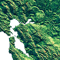
HydroSHEDS는 지역 및 전역 규모 애플리케이션에 수문학 정보를 일관된 형식으로 제공하는 매핑 제품입니다. 하천 네트워크, 유역 경계, 배수 방향, 흐름 누적 등 다양한 규모의 지리 참조 데이터 세트 (벡터 및 래스터)를 제공합니다. HydroSHEDS는 2000년에 NASA의 SRTM (Shuttle Radar Topography Mission)에서 획득한 고도 데이터를 기반으로 합니다.
이 배수 방향 데이터 세트는 조건이 지정된 DEM의 각 셀에서 가장 가파른 하향 경사 이웃으로의 흐름 방향을 정의합니다. 배수 방향 값은 1~128입니다. 바다로 연결되는 모든 최종 출구 셀은 값 0으로 표시됩니다. 내륙 분지의 최저점을 표시하는 모든 셀은 -1 값으로 플래그가 지정됩니다. 배수 방향 값은 ESRI의 흐름 방향 구현에서 채택한 규칙을 따릅니다. 1=E, 2=SE, 4=S, 8=SW, 16=W, 32=NW, 64=N, 128=NE
이 데이터 세트는 3초 해상도입니다.
3초에서 사용할 수 있는 데이터 세트는 빈 공간이 채워진 DEM, 수문학적으로 조건화된 DEM, 배수 (흐름) 방향입니다.
북위 60도 이상의 지역에서는 기본 SRTM 고도 데이터를 사용할 수 없어 더 거친 해상도의 DEM (USGS에서 제공하는 HYDRO1k)이 사용되었기 때문에 HydroSHEDS 데이터의 품질이 크게 낮습니다.
HydroSHEDS는 세계자연기금(WWF) 보존 과학 프로그램이 미국 지질조사국, 국제 열대 농업 센터, 네이처 컨서번시, 독일 카셀 대학교 환경 시스템 연구 센터와 협력하여 개발했습니다.
대역
대역
픽셀 크기: 92.77m (모든 밴드)
| 이름 | 최소 | 최대 | 픽셀 크기 | 설명 |
|---|---|---|---|---|
b1 |
0* | 255* | 92.77m | 배수 방향 가능 값: 1=E, 2=SE, 4=S, 8=SW, 16=W, 32=NW, 64=N, 128=NE; 바다로 이어지는 최종 출구 셀은 값 0으로 표시되고 내륙 분지의 최저점 (내륙 싱크)을 표시하는 셀은 값 255(-1의 원래 값)로 표시됩니다. |
이용약관
이용약관
HydroSHEDS 데이터는 비상업적 및 상업적 용도로 무료로 사용할 수 있습니다. 자세한 내용은 라이선스 계약을 참고하세요.
인용
Lehner, B., Verdin, K., Jarvis, A. (2008): New global hydrography derived from spaceborne elevation data. Eos, Transactions, AGU, 89(10): 93-94.
Earth Engine으로 탐색
코드 편집기(JavaScript)
var dataset = ee.Image('WWF/HydroSHEDS/03DIR');
var drainageDirection = dataset.select('b1');
var drainageDirectionVis = {
  min: 1.0,
  max: 128.0,
  palette: [
    '000000', '023858', '006837', '1a9850', '66bd63', 'a6d96a', 'd9ef8b',
    'ffffbf', 'fee08b', 'fdae61', 'f46d43', 'd73027'
  ],
};
Map.setCenter(-121.652, 38.022, 8);
Map.addLayer(drainageDirection, drainageDirectionVis, 'Drainage Direction');