- Dostępność zbioru danych
- 2000-02-11T00:00:00Z–2000-02-22T00:00:00Z
- Dostawca zbioru danych
- WWF
- Tagi
Opis
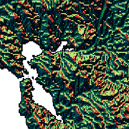
HydroSHEDS to produkt mapowy, który zawiera informacje hydrograficzne do zastosowań regionalnych i globalnych w spójnym formacie. Zawiera on zestaw zbiorów danych geograficznych (wektorowych i rastrowych) o różnej skali, w tym sieci rzeczne, granice działów wód, kierunki odpływu i akumulacje przepływu. HydroSHEDS opiera się na danych o wysokości uzyskanych w 2000 roku przez misję NASA Shuttle Radar Topography Mission (SRTM).
Ten zbiór danych o kierunku spływu określa kierunek spływu z każdej komórki w przygotowanym modelu DEM do sąsiedniej komórki o największym spadku. Wartości kierunku odpływu wahają się od 1 do 128. Wszystkie komórki końcowe odpływu do oceanu są oznaczone wartością 0. Wszystkie komórki, które oznaczają najniższy punkt dorzecza bezodpływowego (zagłębienia śródlądowego), są oznaczone wartością -1. Wartości kierunku odpływu są zgodne z konwencją przyjętą w implementacji kierunku przepływu ESRI: 1=E, 2=SE, 4=S, 8=SW, 16=W, 32=NW, 64=N, 128=NE.
Ten zbiór danych ma rozdzielczość 30 sekund łuku.
Zbiory danych dostępne w rozdzielczości 30 sekund łuku to cyfrowy model terenu z uwzględnieniem warunków hydrologicznych, kierunek spływu i akumulacja przepływu.
Należy pamiętać, że jakość danych HydroSHEDS jest znacznie niższa w przypadku regionów powyżej 60 stopni szerokości geograficznej północnej, ponieważ nie są dostępne dane o wysokości SRTM, a zatem użyto DEM o niższej rozdzielczości (HYDRO1k dostarczony przez USGS).
HydroSHEDS został opracowany przez program Conservation Science organizacji World Wildlife Fund (WWF) we współpracy z U.S. Geological Survey, International Centre for Tropical Agriculture, The Nature Conservancy oraz Center for Environmental Systems Research na Uniwersytecie w Kassel w Niemczech.
Pasma
Pasma
Rozmiar piksela: 927,67 m (wszystkie pasma)
| Nazwa | Minimum | Maks. | Rozmiar piksela | Opis |
|---|---|---|---|---|
b1 |
0* | 255* | 927,67 metra | Możliwe wartości kierunku odpływu: 1=E, 2=SE, 4=S, 8=SW, 16=W, 32=NW, 64=N, 128=NE; komórki ujścia do oceanu są oznaczone wartością 0, a komórki, które oznaczają najniższy punkt bezodpływowego basenu (zagłębienia śródlądowego), są oznaczone wartością 255 (pierwotna wartość –1). |
Warunki korzystania z usługi
Warunki usługi
Dane HydroSHEDS są dostępne bezpłatnie do użytku niekomercyjnego i komercyjnego. Więcej informacji znajdziesz w umowie licencyjnej.
Cytaty
Lehner, B., Verdin, K., Jarvis, A. (2008): New global hydrography derived from spaceborne elevation data. Eos, Transactions, AGU, 89(10): 93-94.
Odkrywaj za pomocą Earth Engine
Edytor kodu (JavaScript)
var dataset = ee.Image('WWF/HydroSHEDS/30DIR');
var drainageDirection = dataset.select('b1');
var drainageDirectionVis = {
  min: 1.0,
  max: 128.0,
  palette: [
    '000000', '023858', '006837', '1a9850', '66bd63', 'a6d96a', 'd9ef8b',
    'ffffbf', 'fee08b', 'fdae61', 'f46d43', 'd73027'
  ],
};
Map.setCenter(-121.652, 38.022, 8);
Map.addLayer(drainageDirection, drainageDirectionVis, 'Drainage Direction');