- در دسترس بودن مجموعه دادهها
- 2000-01-01T00:00:00Z–2021-01-01T00:00:00Z
- تولیدکننده مجموعه داده
- ورلدپاپ
- برچسبها
توضیحات
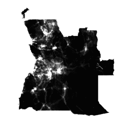
دادههای جهانی با وضوح بالا و معاصر در مورد توزیع جمعیت انسانی، پیشنیاز اندازهگیری دقیق تأثیرات رشد جمعیت، نظارت بر تغییرات و برنامهریزی مداخلات است. پروژه WorldPop با هدف پاسخگویی به این نیازها، مجموعه دادههای توزیع جمعیت دقیق و با دسترسی آزاد را که با استفاده از رویکردهای شفاف و بررسیشده توسط همتا ساخته شدهاند، ارائه میدهد.
جزئیات کامل در مورد روشها و مجموعه دادههای مورد استفاده در ساخت دادهها، همراه با انتشارات با دسترسی آزاد، در وبسایت WorldPop ارائه شده است. به طور خلاصه، شمارش جمعیت مبتنی بر سرشماری اخیر که با واحدهای اداری مرتبط با آنها مطابقت دارد، از طریق رویکردهای یادگیری ماشینی که از روابط بین تراکم جمعیت و طیف وسیعی از لایههای متغیر کمکی جغرافیایی بهرهبرداری میکنند، به سلولهای شبکهای تقریباً ۱۰۰ در ۱۰۰ متر تفکیک میشوند. رویکرد نقشهبرداری، توزیع مجدد داسیمتریک مبتنی بر جنگل تصادفی است.
این مجموعه دادهها تعداد تخمینی افراد ساکن در هر سلول شبکهای را در سالهای ۲۰۱۰، ۲۰۱۵ و سالهای دیگر نشان میدهد.
برای سال ۲۰۲۰، تفکیک جمعیت بر اساس سن و جنس در مجموعههای WorldPop/GP/100m/pop_age_sex و WorldPop/GP/100m/pop_age_sex_cons_unadj موجود است.
مجموعه دادههای شبکهای بیشتر WorldPop در مورد ساختارهای سنی جمعیت، فقر، رشد شهری و پویایی جمعیت به صورت رایگان در وبسایت WorldPop در دسترس است. WorldPop حاصل همکاری بین محققان دانشگاه ساوتهمپتون، دانشگاه آزاد بروکسل و دانشگاه لوییویل است. این پروژه عمدتاً توسط بنیاد بیل و ملیندا گیتس تأمین مالی میشود.
باندها
باندها
اندازه پیکسل: ۹۲.۷۷ متر (همه باندها)
| نام | حداقل | مکس | اندازه پیکسل | توضیحات |
|---|---|---|---|---|
population | 0* | ۲۱۱۷۱* | ۹۲.۷۷ متر | تعداد تخمینی افراد ساکن در هر سلول شبکه |
ویژگیهای تصویر
ویژگیهای تصویر
| نام | نوع | توضیحات |
|---|---|---|
| کشور | رشته | کشور |
| سال | دو برابر | سال |
شرایط استفاده
شرایط استفاده
مجموعه دادههای WorldPop تحت مجوز بینالمللی Creative Commons Attribution 4.0 منتشر میشوند. کاربران میتوانند بدون هیچ محدودیتی، از این اثر برای اهداف تجاری و غیرتجاری استفاده، کپی، توزیع، انتقال و اقتباس کنند، مشروط بر اینکه منبع به روشنی ذکر شود.
نقل قولها
لطفاً وبسایت WorldPop را به عنوان منبع ذکر کنید: www.worldpop.org .
دادههای جمعیتی قاره آمریکا: الساندرو سوریچتا، گریم ام. هورنبی، فارست آر. استیونز، آندرهآ ای. گوگان، کاترین لینارد، اندرو جی. تاتم، ۲۰۱۵، مجموعه دادههای جمعیتی شبکهای با وضوح بالا برای آمریکای لاتین و کارائیب در سالهای ۲۰۱۰، ۲۰۱۵ و ۲۰۲۰، دادههای علمی، doi:10.1038/sdata.2015.45
دادههای شمارش جمعیت آفریقا: Linard, C., Gilbert, M., Snow, RW, Noor, AM and Tatem, AJ, 2012، توزیع جمعیت، الگوهای سکونت و دسترسی در سراسر آفریقا در سال 2010، PLoS ONE، 7(2): e31743.
دادههای شمارش جمعیت آسیا: Gaughan AE، Stevens FR، Linard C، Jia P و Tatem AJ، 2013، نقشههای توزیع جمعیت با وضوح بالا برای جنوب شرقی آسیا در سالهای 2010 و 2015، PLoS ONE، 8(2): e55882.
DOI ها
با موتور زمین کاوش کنید
ویرایشگر کد (جاوااسکریپت)
var dataset = ee.ImageCollection('WorldPop/GP/100m/pop');

var visualization = {
  bands: ['population'],
  min: 0.0,
  max: 50.0,
  palette: ['24126c', '1fff4f', 'd4ff50']
};

Map.setCenter(113.643, 34.769, 7);

Map.addLayer(dataset, visualization, 'Population');
import ee
import geemap.core as geemap
کولب (پایتون)
dataset = ee.ImageCollection('WorldPop/GP/100m/pop')

visualization = {
    'bands': ['population'],
    'min': 0.0,
    'max': 50.0,
    'palette': ['24126c', '1fff4f', 'd4ff50'],
}

m = geemap.Map()
m.set_center(113.643, 34.769, 7)
m.add_layer(dataset, visualization, 'Population')
m