- 카탈로그 소유자
- Global Pasture Watch
- 데이터 세트 제공
- 2000-01-01T00:00:00Z–2023-01-01T00:00:00Z
- 데이터 세트 제공업체
- Land and Carbon Lab Global Pasture Watch
- 문의
- 토지 및 탄소 연구소
- 주기
- 1년
- 태그
설명
이 데이터 세트는 2000년부터 2022년까지 30m 공간 해상도로 초지(경작 및 자연/반자연)의 전 세계 연간 우세 클래스 지도를 제공합니다. Land & Carbon Lab Global Pasture Watch 이니셔티브에서 제작한 매핑된 초지 범위에는 잔디와 초본 (3미만)이 우세하고 다음을 포함하는 건조 또는 습한 저지대 식물이 30% 이상 포함된 모든 토지 피복 유형이 포함됩니다.
- 최대 50% 의 수관 (5미터 초과)
- 기타 목본 식물 (관목 및 개방형 관목지)의 최대 70%
- 농지 및 기타 식생의 모자이크 경관에서 활성 농지 피복 범위가 최대 50% 입니다.
초지 면적은 두 가지 클래스로 분류됩니다. - 경작된 초지: 풀과 기타 사료 식물이 의도적으로 심어지고 관리되는 지역과 가축의 지향성 방목과 같은 특정 인간 지향적 용도로 적극적이고 집중적인 관리가 명확하게 이루어지는 토착 초지 유형 식물 지역 - 자연/반자연 초지: 과거에 다양한 수준의 인간 활동을 경험한 지역뿐만 아니라 스텝, 툰드라와 같이 비교적 방해받지 않은 토착 초지/단신 식물로, 역사적 토지 이용 및 자연적 과정으로 인해 토착종과 도입종이 혼합되어 있을 수 있습니다. 일반적으로 다양한 식물의 자연스러운 패턴과 지형 전체에 걸쳐 명확하게 정렬된 수문학적 관계를 보여줍니다.
구현된 방법론에서는 GLAD Landsat ARD-2 이미지 (구름이 없는 격월 집계로 처리됨, Consoli et al, 2024 참고)를 기후, 지형, 근접성 공변량, 시공간 머신러닝 (클래스별 랜덤 포레스트) 및 230만 개 이상의 참조 샘플 (매우 높은 해상도 이미지에서 시각적으로 해석됨)과 함께 고려했습니다. 5겹 공간 교차 검증과 균형 잡힌 정밀도 및 재현율 값을 기반으로 하는 맞춤 확률 기준값을 사용하여 우세한 클래스 지도를 도출했습니다. 경작지 및 자연/반자연 초지 확률 기준값은 각각 0.32와 0.42입니다.
제한사항: 아프리카 남동부 (짐바브웨 및 모잠비크)와 오스트레일리아 동부 (멀가 생태 지역의 관목지 및 삼림)에서 초지 면적이 부분적으로 과소 예측됩니다. 북아프리카, 아라비아 반도, 서부 오스트레일리아, 뉴질랜드, 볼리비아 중부, 마토그로소주 (브라질) 일부 지역에서 농경지가 초지로 잘못 분류되었습니다. Landsat 7 SLC 오류로 인해 특히 2012년에 필지 수준에서 초지 확률의 규칙적인 스트라이프가 표시됩니다. 더 낮은 해상도 레이어 (접근성 지도 및 MODIS 제품)를 사용하면 우루과이, 아르헨티나 남서부, 앙골라 남부, 아프리카 사헬 지역에 곡선형 거시적 오류 (3차 스플라인 기반 다운스케일링 전략으로 인해)가 발생했습니다. 사용자는 초기 예측 단계에서 지도를 적절하게 사용하기 위해 제한사항과 알려진 문제를 신중하게 고려해야 합니다. GPW는 Geo-Wiki 플랫폼을 통해 체계적인 의견을 수집하고, 현재 버전을 검증하고, 향후 버전의 데이터 세트를 개선하기 위해 적극적으로 노력하고 있습니다.
자세한 내용은 Parente et. al, 2024, Zenodo 및 Global Pasture Watch GitHub 사이트를 참고하세요.
대역
대역
| 이름 | 최소 | 최대 | 픽셀 크기 | 설명 |
|---|---|---|---|---|
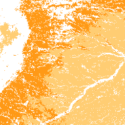
dominant_class |
0 | 2 | 30미터 | 랜덤 포레스트와 확률 지도를 통해 파생된 지배적인 클래스입니다. |
dominant_class 클래스 표
| 값 | 색상 | 설명 |
|---|---|---|
| 0 | #ffffff | 기타 |
| 1 | #ffcd73 | 경작된 초지 |
| 2 | #ff9916 | 자연/반자연 초지 |
이미지 속성
이미지 속성
| 이름 | 유형 | 설명 |
|---|---|---|
| version | INT | 제품 버전 |
이용약관
이용약관
인용
Parente, L., Sloat, L., Mesquita, V., et al. (2024) Global Pasture Watch - 30m 공간 해상도의 연간 초지 등급 및 범위 지도 (2000~2022년) (버전 v1) [데이터 세트]. Zenodo doi:https://doi.org/10.5281/zenodo.13890401
Parente, L., Sloat, L., Mesquita, V., et al. (2024). 시공간 머신러닝을 기반으로 한 전 세계 초지 등급 및 범위의 연간 30m 지도 (2000~2022년), Scientific Data. doi: http://doi.org/10.1038/s41597-024-04139-6
DOI
Earth Engine으로 탐색
코드 편집기(JavaScript)
Map.setCenter(-49.265188, -16.602052, 4);

var domi_grassland = ee.ImageCollection(
  "projects/global-pasture-watch/assets/ggc-30m/v1/grassland_c"
)
var visParams = {"opacity":1, "min":1,"max":2,"palette":["ffcd73","ff9916"]};

var domi_grassland_2022 = domi_grassland.filterDate('2022-01-01', '2023-01-01').first();
Map.addLayer(
    domi_grassland_2022.selfMask(),
    visParams, 'Dominant grassland class (2022)'
);

var domi_grassland_2000 = domi_grassland.filterDate('2000-01-01', '2001-01-01').first();
Map.addLayer(
    domi_grassland_2000.selfMask(),
    visParams, 'Dominant grassland class (2000)'
);