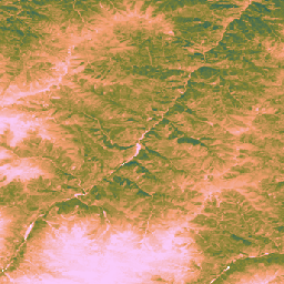
تقدّم مجموعة البيانات هذه إجمالي الإنتاج الأولي العالمي غير المعاير المستند إلى مراقبة الأرض منذ عام 2000 بدقة مكانية تبلغ 30 مترًا.
توفّر مجموعة البيانات الحالية، التي تم إنتاجها من خلال مبادرة Land & Carbon Lab Global Pasture Watch، قيم "إجمالي الإنتاج الأولي" (GPP) على مستوى العالم بدقة مكانية تبلغ 30 مترًا منذ عام 2000.
يتم تصميم قيم GPP باستخدام نهج كفاءة الاستخدام الخفيف (LUE)، حيث يتم تجميع بيانات GLAD Landsat ARD (المجموعة 2) كل شهرين (Consoli وآخرون، 2024) وتم دمجها مع بيانات درجة الحرارة من MODIS بدقة 1 كم والإشعاع النشط ضوئيًا (PAR) من CERES بدقة 1 درجة.
للحفاظ على مرونة مجموعة البيانات، تم ضبط الحد الأقصى لكفاءة استخدام الضوء (LUEmax) على 1 غرام كربون/متر مربع/يوم/ميغا جول �0x0A>لجميع أنواع الغطاء الأرضي، ما يتيح للمستخدمين معايرة قيم الإنتاج الأولي الإجمالي (GPP) لاحقًا وفقًا لخرائط الغطاء الأرضي المحددة أو الظروف الإقليمية.
يتم حساب متوسط قيم الإنتاجية الأولية الإجمالية غير المعايرة (uGPP) كل شهرين (المتاحة في OpenLandMap STAC) لكل عام، ويتم تجميعها على مدار فترة 365 يومًا كاملة لإنتاج قيم uGPP السنوية العالمية، ويتم التعبير عنها بوحدات غرام كربون/متر مربع/سنة.
عدم تطابق دقة بيانات الإدخال: يتم توفير مجموعة البيانات بدقة 30 مترًا، ولكن تم استخلاص متغيرات الإدخال الرئيسية لدرجة الحرارة (MOD11A1)
والإشعاع النشط ضوئيًا (CERES PAR) من منتجات أكثر دقة (1 كيلومتر و111 كيلومترًا تقريبًا على التوالي).
يمكن أن يؤدي تقليل دقة هذه المعلومات إلى عدم اليقين وقد لا يرصد الظروف المناخية الدقيقة على المستوى الصغير التي تؤثر في إنتاجية النباتات.
البيانات غير المرغوب فيها: تحتوي مجموعة البيانات على بيانات مرئية غير مرغوب فيها معروفة، بما في ذلك خطوط عمودية ("تأثير الخطوط") في بعض المناطق، وهي ناتجة عن مشاكل في مستشعر Landsat 7 (تعطُّل أداة تصحيح خطوط المسح) وعملية ملء الفجوات اللاحقة المستخدَمة لإنشاء أرشيف الانعكاس الأساسي (Consoli et al., 2024). ويمكن أن تؤدي هذه التشوهات إلى تعطيل الاستمرارية المكانية لتقديرات الإنتاج الأولي الإجمالي خلال فترات الغطاء السحابي والثلجي.
الدقة الزمنية: يتم إنتاج البيانات بدقة زمنية كل شهرين. قد لا يكون هذا الإطار الزمني كافيًا لتسجيل فترات النمو الرئيسية أو الاستجابات السريعة للنبات (هطول الأمطار الغزيرة) للتغييرات البيئية، ما يجعل من الصعب تسجيل ذروات الإنتاجية والتغيّر الموسمي بدقة.
معايرة الأراضي العشبية: يتم احتساب قيم الإنتاج الأولي الإجمالي للأراضي العشبية باستخدام مَعلم واحد لأقصى كفاءة في استخدام الضوء (LUEmax)
(0.86 غرام كربون/متر مربع/سنة/ميغا جول) لجميع الأراضي العشبية في العالم، استنادًا إلى خوارزمية MOD17. هذه القيمة غير محسّنة لأنواع محددة من الأراضي العشبية أو الظروف المحلية. نتيجةً لذلك، يميل النموذج إلى التقليل من تقدير GPP عند مقارنته بالقياسات التي يتم إجراؤها باستخدام أبراج تدفّق أرضية.
الاعتماد على دقة خرائط الأراضي العشبية: تعتمد دقة قيم الإنتاج الأولي الإجمالي للأراضي العشبية على دقة خرائط الأراضي العشبية في GPW الأساسية.
سيؤدي أي تصنيف خاطئ للغطاء الأرضي في الخرائط المصدر (مثل تصنيف الأراضي الشجرية أو الأراضي الزراعية على أنّها أراضٍ عشبية) إلى حدوث أخطاء مماثلة في تقديرات GPP الخاصة بهذه المواقع الجغرافية.
Isik, M. S., Mesquita, V., Parente, L., & Consoli, D. (2025).
Global Pasture Watch - رمز المصدر لخرائط GPP العالمية غير المعايرة المستندة إلى بيانات رصد الأرض (EO) وخرائط GPP الخاصة بالأراضي العشبية بدقة 30 مترًا Zenodo.
[Source code]. Zenodo
doi:https://doi.org/10.5281/zenodo.15675358
Isik MS, Parente L, Consoli D, et al. (2025).
Light use efficiency (LUE) based bimonthly gross primary
productivity (GPP) for global grasslands at 30 m spatial
resolution (2000–2022), PeerJ.
doi: https://doi.org/10.7717/peerj.19774
توفّر مجموعة البيانات هذه إجمالي الإنتاج الأولي العالمي غير المعاير المستند إلى بيانات رصد الأرض منذ عام 2000 بدقة مكانية تبلغ 30 مترًا. توفّر مجموعة البيانات الحالية، التي تم إنتاجها من خلال مبادرة Land & Carbon Lab Global Pasture Watch، قيم الإنتاج الأولي الإجمالي (GPP) على مستوى العالم بدقة مكانية تبلغ 30 مترًا منذ عام 2000. يتم تصميم قيم GPP من خلال استخدام خفيف …
[null,null,[],[],[],null,["# GPW Annual uncalibrated Gross Primary Productivity (uGPP) v1\n\ninfo\n\n\nThis dataset is part of a Publisher Catalog, and not managed by Google Earth Engine.\n\nContact [Land \\& Carbon Lab](https://landcarbonlab.org/subscribe)\n\nfor bugs or [view more datasets](https://developers.google.com/earth-engine/datasets/publisher/global-pasture-watch)\nfrom the Global Pasture Watch Catalog. [Learn more about Publisher datasets](/earth-engine/datasets/publisher). \n[](https://landcarbonlab.org/data/global-grassland-and-livestock-monitoring) \n\nCatalog Owner\n: Global Pasture Watch\n\nDataset Availability\n: 2000-01-01T00:00:00Z--2024-01-01T00:00:00Z\n\nDataset Provider\n:\n\n\n [Land and Carbon Lab Global Pasture Watch](https://landcarbonlab.org/data/global-grassland-and-livestock-monitoring)\n\nContact\n: [Land \\& Carbon Lab](https://landcarbonlab.org/subscribe)\n\nCadence\n: 1 Year\n\nTags\n:\n[global](/earth-engine/datasets/tags/global) [global-pasture-watch](/earth-engine/datasets/tags/global-pasture-watch) [land](/earth-engine/datasets/tags/land) [landcover](/earth-engine/datasets/tags/landcover) [landuse](/earth-engine/datasets/tags/landuse) [plant-productivity](/earth-engine/datasets/tags/plant-productivity) [publisher-dataset](/earth-engine/datasets/tags/publisher-dataset) [vegetation](/earth-engine/datasets/tags/vegetation) \n\n#### Description\n\nThis dataset provides global uncalibrated EO-based Gross Primary Productivity\nfrom 2000 at 30-m spatial resolution.\nProduced by Land \\& Carbon Lab Global Pasture Watch initiative, the current dataset provides\nGross Primary Productivity (GPP) values globally at 30-m spatial resolution from 2000 onwards.\nGPP values are modeled via a **light use efficiency (LUE)** approach,\nwhere [**GLAD Landsat ARD** (collection-2)](https://glad.umd.edu/ard/home) are aggregated every two months\n([Consoli et al., 2024](https://peerj.com/articles/18585/)) and combined with 1-km **MODIS\ntemperature** data and 1° **CERES Photosynthetically Active Radiation** (PAR).\n\nTo keep the dataset flexible, the maximum light use efficiency (LUEmax) is set to 1 gC/m²/day/MJ\nfor **all land cover types**, allowing the users to later calibrate the\nGPP values according to specific land cover maps or regional conditions.\n\n**Bi-monthly uncalibrated Gross Primary Productivity (uGPP)** values (available in [OpenLandMap STAC](https://stac.openlandmap.org/gpw_ugpp.daily-30m/collection.json)) are averaged by each year and accumulated over the full 365-day period to produce\nglobal annual uGPP values, expressed in units of gC/m²/year.\n\n**Grassland GPP** values are computed on-the-fly using [GEE App](https://global-pasture-watch.projects.earthengine.app/view/ggpp-30m).\n\n**Limitations:**\n\n- **Input data resolution mismatch**: The dataset is provided at 30 m resolution, but key input variables for temperature (MOD11A1)\n and photosynthetically active radiation (CERES PAR) were derived from much coarser products (1 km and \\~111 km, respectively).\n The downscaling of this information can introduce uncertainty and may not capture fine-scale microclimatic conditions affecting plant productivity.\n\n- **Data artifacts** : The dataset contains known visual artifacts, including vertical stripes (\"stripe effect\") in some areas, which are a result\n of issues with the Landsat 7 sensor (Scan Line Corrector failure) and the subsequent gap-filling process used to create the underlying\n reflectance archive ([Consoli et al., 2024](https://peerj.com/articles/18585/)). These artifacts can disrupt the spatial continuity\n of GPP estimates during cloudy and snow cover periods\n\n- **Temporal resolution**: The data is produced at a bimonthly temporal resolution. This timeframe may not be sufficient\n to capture key growth periods or a plant's rapid responses (intense rainfall) to environmental changes, making\n it difficult to accurately capture productivity peaks and seasonal variation.\n\n- **Grassland calibration**: Grassland GPP values are calculated using a single maximum light use efficiency (LUEmax)\n parameter (0.86 gC/m²/year/MJ) for all global grasslands, based on the MOD17 algorithm. This value is not optimized\n for specific grassland types or local conditions. As a result, the model shows a tendency to underestimate GPP when\n compared to ground-based flux tower measurements.\n\n- **Dependence on grassland maps accuracy** : The accuracy of the grassland GPP values is contingent on the accuracy of the\n underlying [GPW grassland maps](https://developers.google.com/earth-engine/datasets/catalog/projects_global-pasture-watch_assets_ggc-30m_v1_grassland_c).\n Any misclassification of land cover in the source maps (e.g., shrublands or croplands identified as grassland) will\n lead to corresponding errors in the GPP estimates for those locations.\n\n**For more information see [Isik et. al, 2025](https://doi.org/10.7717/peerj.19774),\n[Zenodo](https://doi.org/10.5281/zenodo.15675358) and\n[Global Pasture Watch GitHub site](https://github.com/wri/global-pasture-watch)**\n\n### Bands\n\n**Bands**\n\n| Name | Min | Max | Pixel Size | Description |\n|---------|-----|------|------------|--------------------------------------------------------|\n| `gc_m2` | 0 | 4000 | 30 meters | Grams of carbon per square meter per year (gC/m²/year) |\n\n### Image Properties\n\n**Image Properties**\n\n| Name | Type | Description |\n|---------|------|-----------------|\n| version | INT | Product version |\n\n### Terms of Use\n\n**Terms of Use**\n\n[CC-BY-4.0](https://spdx.org/licenses/CC-BY-4.0.html)\n\n### Citations\n\nCitations:\n\n- Isik, M. S., Mesquita, V., Parente, L., \\& Consoli, D. (2025).\n Global Pasture Watch - Source Code of the Global Uncalibrated EO-based GPP and\n Grassland GPP Maps at 30m. Zenodo.\n \\[Source code\\]. Zenodo\n [doi:https://doi.org/10.5281/zenodo.15675358](https://doi.org/10.5281/zenodo.15675358)\n- Isik MS, Parente L, Consoli D, et al. (2025).\n Light use efficiency (LUE) based bimonthly gross primary\n productivity (GPP) for global grasslands at 30 m spatial\n resolution (2000--2022), PeerJ.\n [doi: https://doi.org/10.7717/peerj.19774](https://doi.org/10.7717/peerj.19774)\n\n### DOIs\n\n- \u003chttps://doi.org/10.5281/zenodo.13890401\u003e\n- \u003chttps://doi.org/10.7717/peerj.19774\u003e\n\n### Explore with Earth Engine\n\n| **Important:** Earth Engine is a platform for petabyte-scale scientific analysis and visualization of geospatial datasets, both for public benefit and for business and government users. Earth Engine is free to use for research, education, and nonprofit use. To get started, please [register for Earth Engine access.](https://console.cloud.google.com/earth-engine)\n\n### Code Editor (JavaScript)\n\n```javascript\nMap.setCenter(-49.265188, -16.602052, 4);\n\nvar ugppVis = {min: 0, max: 4000, palette: \"faccfa,f19d6b,828232,226061,011959\"}\nvar ugpp = ee.ImageCollection(\n \"projects/global-pasture-watch/assets/ggpp-30m/v1/ugpp_m\"\n)\n\nvar ugpp2024 = ugpp.filterDate('2024-01-01', '2025-01-01').first();\nMap.addLayer(ugpp2024, ugppVis, 'Uncalibrated GPP (2024)');\n\nvar ugpp2000 = ugpp.filterDate('2000-01-01', '2001-01-01').first();\nMap.addLayer(ugpp2000, ugppVis, 'Uncalibrated GPP (2000)');\n```\n[Open in Code Editor](https://code.earthengine.google.com/?scriptPath=Examples:Datasets/global-pasture-watch/projects_global-pasture-watch_assets_ggpp-30m_v1_ugpp_m) \n[GPW Annual uncalibrated Gross Primary Productivity (uGPP) v1](/earth-engine/datasets/catalog/projects_global-pasture-watch_assets_ggpp-30m_v1_ugpp_m) \nThis dataset provides global uncalibrated EO-based Gross Primary Productivity from 2000 at 30-m spatial resolution. Produced by Land \\& Carbon Lab Global Pasture Watch initiative, the current dataset provides Gross Primary Productivity (GPP) values globally at 30-m spatial resolution from 2000 onwards. GPP values are modeled via a light use ... \nprojects/global-pasture-watch/assets/ggpp-30m/v1/ugpp_m, global,global-pasture-watch,land,landcover,landuse,plant-productivity,publisher-dataset,vegetation \n2000-01-01T00:00:00Z/2024-01-01T00:00:00Z \n-90 -180 90 180 \nGoogle Earth Engine \nhttps://developers.google.com/earth-engine/datasets\n\n- [https://doi.org/10.7717/peerj.19774](https://doi.org/https://landcarbonlab.org/data/global-grassland-and-livestock-monitoring)\n- [https://doi.org/10.7717/peerj.19774](https://doi.org/https://developers.google.com/earth-engine/datasets/catalog/projects_global-pasture-watch_assets_ggpp-30m_v1_ugpp_m)"]]