- Proprietario del catalogo
- Global Pasture Watch
- Disponibilità del set di dati
- 2000-01-01T00:00:00Z–2024-01-01T00:00:00Z
- Fornitore di set di dati
- Land and Carbon Lab Global Pasture Watch
- Contatto
- Land & Carbon Lab
- Cadenza
- 1 anno
- Tag
Descrizione
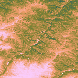
Questo set di dati fornisce la produttività primaria lorda globale non calibrata basata sull'EO dal 2000 con una risoluzione spaziale di 30 metri. Prodotto dall'iniziativa Global Pasture Watch del Land & Carbon Lab, il set di dati attuale fornisce valori di produttività primaria lorda (GPP) a livello globale con una risoluzione spaziale di 30 metri a partire dal 2000. I valori GPP vengono modellati tramite un approccio di efficienza di utilizzo della luce (LUE), in cui GLAD Landsat ARD (raccolta 2) vengono aggregati ogni due mesi (Consoli et al., 2024) e combinati con dati di temperatura MODIS di 1 km e radiazione fotosinteticamente attiva CERES (PAR) di 1°.
Per mantenere flessibile il set di dati, l'efficienza massima di utilizzo della luce (LUEmax) è impostata su 1 gC/m²/giorno/MJ per tutti i tipi di copertura del suolo, consentendo agli utenti di calibrare in un secondo momento i valori di GPP in base a mappe di copertura del suolo specifiche o a condizioni regionali.
I valori bi-mensili della produttività primaria lorda (uGPP) non calibrata (disponibili in OpenLandMap STAC) vengono calcolati in media per ogni anno e accumulati nell'intero periodo di 365 giorni per produrre valori uGPP annuali globali, espressi in unità di gC/m²/anno.
I valori di GPP per le praterie vengono calcolati al volo utilizzando l'app GEE.
Limitazioni:
Mancata corrispondenza della risoluzione dei dati di input: il set di dati viene fornito con una risoluzione di 30 m, ma le variabili di input chiave per la temperatura (MOD11A1) e la radiazione fotosinteticamente attiva (CERES PAR) sono state derivate da prodotti molto più grossolani (rispettivamente 1 km e circa 111 km). La riduzione della scala di queste informazioni può introdurre incertezza e potrebbe non acquisire le condizioni microclimatiche su piccola scala che influiscono sulla produttività delle piante.
Artefatti dei dati: il set di dati contiene artefatti visivi noti, tra cui strisce verticali ("effetto striscia") in alcune aree, che sono il risultato di problemi con il sensore Landsat 7 (guasto dello Scan Line Corrector) e del successivo processo di riempimento delle lacune utilizzato per creare l'archivio di riflettanza sottostante (Consoli et al., 2024). Questi artefatti possono interrompere la continuità spaziale delle stime della GPP durante i periodi di copertura nuvolosa e nevosa
Risoluzione temporale: i dati vengono prodotti con una risoluzione temporale quindicinale. Questo periodo di tempo potrebbe non essere sufficiente per acquisire i periodi di crescita chiave o le risposte rapide di una pianta (piogge intense) ai cambiamenti ambientali, rendendo difficile acquisire con precisione i picchi di produttività e le variazioni stagionali.
Calibrazione delle praterie: i valori GPP delle praterie vengono calcolati utilizzando un singolo parametro di efficienza massima di utilizzo della luce (LUEmax) (0,86 gC/m²/anno/MJ) per tutte le praterie globali, in base all'algoritmo MOD17. Questo valore non è ottimizzato per tipi specifici di praterie o condizioni locali. Di conseguenza, il modello mostra una tendenza a sottostimare la GPP rispetto alle misurazioni della torre di flusso a terra.
Dipendenza dall'accuratezza delle mappe delle praterie: l'accuratezza dei valori di GPP delle praterie dipende dall'accuratezza delle mappe delle praterie GPW sottostanti. Qualsiasi classificazione errata della copertura del suolo nelle mappe di origine (ad es. arbusteti o terreni coltivati identificati come praterie) comporterà errori corrispondenti nelle stime della GPP per queste località.
Per maggiori informazioni, consulta Isik et al., 2025, Zenodo e sito GitHub di Global Pasture Watch
Bande
Bande
| Nome | Min | Max | Dimensioni dei pixel | Descrizione |
|---|---|---|---|---|
gc_m2 |
0 | 4000 | 30 metri | Grammi di carbonio per metro quadrato all'anno (gC/m²/anno) |
Proprietà immagini
Proprietà immagini
| Nome | Tipo | Descrizione |
|---|---|---|
| versione | INT | Versione del prodotto |
Termini e condizioni d'uso
Termini e condizioni d'uso
Citazioni
Isik, M. S., Mesquita, V., Parente, L., & Consoli, D. (2025). Global Pasture Watch - Source Code of the Global Uncalibrated EO-based GPP and Grassland GPP Maps at 30m. Zenodo. [Codice sorgente]. Zenodo doi:https://doi.org/10.5281/zenodo.15675358
Isik MS, Parente L, Consoli D, et al. (2025). Light use efficiency (LUE) based bimonthly gross primary productivity (GPP) for global grasslands at 30 m spatial resolution (2000–2022), PeerJ. doi: https://doi.org/10.7717/peerj.19774
DOI
Esplorare con Earth Engine
Editor di codice (JavaScript)
Map.setCenter(-49.265188, -16.602052, 4);

var ugppVis = {min: 0, max: 4000, palette: "faccfa,f19d6b,828232,226061,011959"}
var ugpp = ee.ImageCollection(
    "projects/global-pasture-watch/assets/ggpp-30m/v1/ugpp_m"
)

var ugpp2024 = ugpp.filterDate('2024-01-01', '2025-01-01').first();
Map.addLayer(ugpp2024, ugppVis, 'Uncalibrated GPP (2024)');

var ugpp2000 = ugpp.filterDate('2000-01-01', '2001-01-01').first();
Map.addLayer(ugpp2000, ugppVis, 'Uncalibrated GPP (2000)');