- Владелец каталога
- Проект «Атлас малярии»
- Доступность набора данных
- 2001-02-01T00:00:00Z–2024-12-01T00:00:00Z
- Поставщик наборов данных
- Проект «Атлас малярии»
- Контакт
- Проект «Атлас малярии»
- Каденция
- 1 месяц
- Теги
Описание
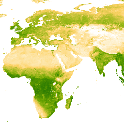
Базовым набором данных для этого продукта Enhanced Vegetation Index (EVI) являются изображения MODIS BRDF (MCD43B4), в которых пропуски были заполнены с помощью подхода, описанного в работе Weiss et al. (2014), для устранения пропусков данных, вызванных такими факторами, как облачность. После заполнения пропусков данные были ограничены пороговыми значениями [0, 1] для обеспечения достоверности значений.
Затем 8-дневные результаты измерений протяженностью ~1 км с заполненными пробелами суммируются по времени для получения ежемесячных и годовых результатов.
Группы
Размер пикселя
5000 метров
Группы
| Имя | Мин. | Макс | Размер пикселя | Описание |
|---|---|---|---|---|
Mean | 0* | 1* | метров | Среднее значение улучшенного индекса растительности для каждого агрегированного пикселя. |
Условия эксплуатации
Условия эксплуатации
Цитаты
Вайс, Дж. Д., П. М. Аткинсон, С. Бхатт, Б. Маппин, С. И. Хей и П. В. Гетинг (2014) Эффективный подход к заполнению пробелов в данных дистанционного зондирования континентального масштаба. Журнал фотограмметрии и дистанционного зондирования ISPRS, 98, 106–118. doi:10.1016/j.isprsjprs.2014.10.001
Исследуйте с Earth Engine
Редактор кода (JavaScript)
var dataset = ee.ImageCollection('projects/malariaatlasproject/assets/EVI_v061/1km/Monthly')
                  .filter(ee.Filter.date('2022-01-01', '2022-12-31'));
var means = dataset.select('Mean');
var visParams = {
  min: 0.0,
  max: 1.0,
  palette: ['ffffff','fcd163','99b718','66a000','3e8601','207401','056201','004c00','011301'],
};
Map.setCenter(0, 0, 2);
Map.addLayer(means, visParams, 'Monthly EVI: Malaria Atlas Project Gap-Filled Enhanced Vegetation Index');