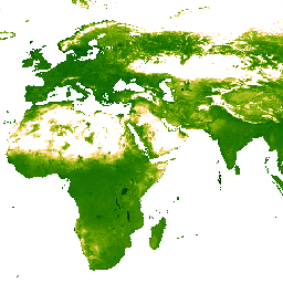
Questo set di dati sulla luminosità Tasseled Cap (TCB) con valori mancanti è stato creato applicando le equazioni Tasseled Cap definite in Lobser e Cohen (2007) alle immagini corrette BRDF MODIS (MCD43B4). I dati risultanti sono stati riempiti
utilizzando l'approccio descritto in Weiss et al. (2014) per eliminare i dati mancanti
causati da fattori come la copertura nuvolosa. Dopo il riempimento delle lacune, i dati sono stati troncati alle soglie di [-1, 2] per garantire valori validi.
Gli output di circa 1 km con i dati mancanti vengono poi aggregati temporalmente per produrre prodotti mensili e annuali.
Bande
Dimensioni in pixel 5000 metri
Bande
Nome
Min
Max
Dimensioni dei pixel
Descrizione
Mean
0*
1,99*
metri
Il valore medio della luminosità del cappello con nappe per ogni pixel aggregato.
Weiss, D.J., P.M. Atkinson, S. Bhatt, B. Mappin, S.I. Hay & P.W. Gething
(2014) An effective approach for gap-filling continental scale remotely
sensed time-series. ISPRS Journal of Photogrammetry and Remote Sensing,
98, 106-118.
doi:10.1016/j.isprsjprs.2014.10.001
Lobser, S.E. & Cohen, W.B. (2007) MODIS tasselled cap: land cover
characteristics expressed through transformed MODIS data. International
Journal of Remote Sensing, 28, 5079-5101.
Questo set di dati sulla luminosità del Tasseled Cap (TCB) con valori mancanti è stato creato applicando le equazioni del Tasseled Cap definite in Lobser e Cohen (2007) alle immagini corrette BRDF di MODIS (MCD43B4). I dati risultanti sono stati riempiti utilizzando l'approccio descritto in Weiss et al. (2014) per eliminare i dati mancanti causati da fattori come la copertura nuvolosa. …
[null,null,[],[],[],null,["info\n\n\nThis dataset is part of a Publisher Catalog, and not managed by Google Earth Engine.\n\nContact [The Malaria Atlas Project](/earth-engine/datasets/catalog/data.malariaatlas.org@thekids.org.au)\n\nfor bugs or [view more datasets](https://developers.google.com/earth-engine/datasets/publisher/malariaatlasproject)\nfrom the The Malaria Atlas Project Catalog. [Learn more about Publisher datasets](/earth-engine/datasets/publisher). \n[](https://data.malariaatlas.org) \n\nCatalog Owner\n: The Malaria Atlas Project\n\nDataset Availability\n: 2001-02-01T00:00:00Z--2024-12-26T00:00:00Z\n\nDataset Provider\n:\n\n\n [The Malaria Atlas Project](https://www.malariaatlas.org)\n\nContact\n: [The Malaria Atlas Project](/earth-engine/datasets/catalog/data.malariaatlas.org@thekids.org.au)\n\nCadence\n: 8 Days\n\nTags\n:\n[brightness](/earth-engine/datasets/tags/brightness) [malariaatlasproject](/earth-engine/datasets/tags/malariaatlasproject) [map](/earth-engine/datasets/tags/map) [publisher-dataset](/earth-engine/datasets/tags/publisher-dataset) [tasseled-cap](/earth-engine/datasets/tags/tasseled-cap) [tcb](/earth-engine/datasets/tags/tcb) [vegetation](/earth-engine/datasets/tags/vegetation) [vegetation-indices](/earth-engine/datasets/tags/vegetation-indices) \n\nDescription \nThis gap-filled Tasseled Cap Brightness (TCB) dataset was created by\napplying the tasseled-cap equations defined in Lobser and Cohen (2007) to\nMODIS BRDF-corrected imagery (MCD43B4). The resulting data were gap-filled\nusing the approach outlined in Weiss et al. (2014) to eliminate missing\ndata caused by factors such as cloud cover. After gap-filling the data was clipped to thresholds of \\[-1, 2\\] to ensure valid values.\n\nThe gap-filled 8-daily \\~1km outputs are then aggregated temporally to produce monthly and annual products.\n\nBands\n\n\n**Pixel Size**\n\n5000 meters\n\n**Bands**\n\n| Name | Min | Max | Pixel Size | Description |\n|--------|-----|--------|------------|----------------------------------------------------------------------|\n| `Mean` | 0\\* | 1.99\\* | meters | The mean value of Tasseled Cap Brightness for each aggregated pixel. |\n\n\\* estimated min or max value\n\nTerms of Use\n\n**Terms of Use**\n\n[CC-BY-NC-SA-4.0](https://spdx.org/licenses/CC-BY-NC-SA-4.0.html)\n\nCitations \nCitations:\n\n- Weiss, D.J., P.M. Atkinson, S. Bhatt, B. Mappin, S.I. Hay \\& P.W. Gething\n (2014) An effective approach for gap-filling continental scale remotely\n sensed time-series. ISPRS Journal of Photogrammetry and Remote Sensing,\n 98, 106-118.\n [doi:10.1016/j.isprsjprs.2014.10.001](https://doi.org/10.1016/j.isprsjprs.2014.10.001)\n- Lobser, S.E. \\& Cohen, W.B. (2007) MODIS tasselled cap: land cover\n characteristics expressed through transformed MODIS data. International\n Journal of Remote Sensing, 28, 5079-5101.\n\nExplore with Earth Engine **Important:** Earth Engine is a platform for petabyte-scale scientific analysis and visualization of geospatial datasets, both for public benefit and for business and government users. Earth Engine is free to use for research, education, and nonprofit use. To get started, please [register for Earth Engine access.](https://console.cloud.google.com/earth-engine)\n\nCode Editor (JavaScript) \n\n```javascript\nvar dataset = ee.ImageCollection('projects/malariaatlasproject/assets/TCB_v061/1km/8-Daily')\n .filter(ee.Filter.date('2022-01-01', '2022-04-01'));\nvar means = dataset.select('Mean');\nvar visParams = {\n min: 0.0,\n max: 1.3,\n palette: ['011301','004c00','056201','207401','3e8601','66a000','99b718','fcd163','ffffff'],\n};\nMap.setCenter(0, 0, 2);\nMap.addLayer(means, visParams, '8-Daily TCB: Malaria Atlas Project Gap-Filled Tasseled Cap Brightness');\n```\n[Open in Code Editor](https://code.earthengine.google.com/?scriptPath=Examples:Datasets/malariaatlasproject/projects_malariaatlasproject_assets_TCB_v061_1km_8-Daily) \n[TCB: Malaria Atlas Project Gap-Filled Tasseled Cap Brightness (8-Daily 1km)](/earth-engine/datasets/catalog/projects_malariaatlasproject_assets_TCB_v061_1km_8-Daily) \nThis gap-filled Tasseled Cap Brightness (TCB) dataset was created by applying the tasseled-cap equations defined in Lobser and Cohen (2007) to MODIS BRDF-corrected imagery (MCD43B4). The resulting data were gap-filled using the approach outlined in Weiss et al. (2014) to eliminate missing data caused by factors such as cloud cover. ... \nprojects/malariaatlasproject/assets/TCB_v061/1km/8-Daily, brightness,malariaatlasproject,map,publisher-dataset,tasseled-cap,tcb,vegetation,vegetation-indices \n2001-02-01T00:00:00Z/2024-12-26T00:00:00Z \n-90 -180 90 180 \nGoogle Earth Engine \nhttps://developers.google.com/earth-engine/datasets\n\n- [](https://doi.org/https://www.malariaatlas.org)\n- [](https://doi.org/https://developers.google.com/earth-engine/datasets/catalog/projects_malariaatlasproject_assets_TCB_v061_1km_8-Daily)"]]