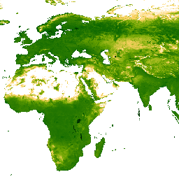
이 갭이 채워진 Tasseled Cap Brightness (TCB) 데이터 세트는 Lobser 및 Cohen (2007)에 정의된 tasseled-cap 방정식을 MODIS BRDF 보정 이미지 (MCD43B4)에 적용하여 생성되었습니다. 결과 데이터는 Weiss et al. (2014)에 설명된 접근 방식을 사용하여 갭을 채워 구름 덮개와 같은 요인으로 인해 누락된 데이터를 제거했습니다. 데이터를 갭 필링한 후 유효한 값을 보장하기 위해 [-1, 2] 의 임계값으로 클리핑했습니다.
그런 다음 갭이 채워진 8일 간격의 ~1km 출력이 시간별로 집계되어 월별 및 연간 제품이 생성됩니다.
Weiss, D.J., P.M. Atkinson, S. Bhatt, B. Mappin, S.I. Hay & P.W. Gething
(2014) An effective approach for gap-filling continental scale remotely
sensed time-series. ISPRS Journal of Photogrammetry and Remote Sensing,
98, 106-118.
doi:10.1016/j.isprsjprs.2014.10.001
Lobser, S.E. & Cohen, W.B. (2007) MODIS tasselled cap: land cover
characteristics expressed through transformed MODIS data. International
Journal of Remote Sensing, 28, 5079-5101.
이 갭 필드 Tasseled Cap Brightness (TCB) 데이터 세트는 Lobser 및 Cohen (2007)에 정의된 tasseled-cap 방정식을 MODIS BRDF 보정 이미지 (MCD43B4)에 적용하여 생성되었습니다. 결과 데이터는 구름 덮개와 같은 요인으로 인해 누락된 데이터를 제거하기 위해 Weiss et al. (2014)에 설명된 접근 방식을 사용하여 간격이 채워졌습니다. …
[null,null,[],[],[],null,["info\n\n\nThis dataset is part of a Publisher Catalog, and not managed by Google Earth Engine.\n\nContact [The Malaria Atlas Project](/earth-engine/datasets/catalog/data.malariaatlas.org@thekids.org.au)\n\nfor bugs or [view more datasets](https://developers.google.com/earth-engine/datasets/publisher/malariaatlasproject)\nfrom the The Malaria Atlas Project Catalog. [Learn more about Publisher datasets](/earth-engine/datasets/publisher). \n[](https://data.malariaatlas.org) \n\nCatalog Owner\n: The Malaria Atlas Project\n\nDataset Availability\n: 2001-02-01T00:00:00Z--2024-01-01T00:00:00Z\n\nDataset Provider\n:\n\n\n [The Malaria Atlas Project](https://www.malariaatlas.org)\n\nContact\n: [The Malaria Atlas Project](/earth-engine/datasets/catalog/data.malariaatlas.org@thekids.org.au)\n\nCadence\n: 1 Year\n\nTags\n:\n[brightness](/earth-engine/datasets/tags/brightness) [malariaatlasproject](/earth-engine/datasets/tags/malariaatlasproject) [map](/earth-engine/datasets/tags/map) [publisher-dataset](/earth-engine/datasets/tags/publisher-dataset) [tasseled-cap](/earth-engine/datasets/tags/tasseled-cap) [tcb](/earth-engine/datasets/tags/tcb) [vegetation](/earth-engine/datasets/tags/vegetation) [vegetation-indices](/earth-engine/datasets/tags/vegetation-indices) \n\nDescription \nThis gap-filled Tasseled Cap Brightness (TCB) dataset was created by\napplying the tasseled-cap equations defined in Lobser and Cohen (2007) to\nMODIS BRDF-corrected imagery (MCD43B4). The resulting data were gap-filled\nusing the approach outlined in Weiss et al. (2014) to eliminate missing\ndata caused by factors such as cloud cover. After gap-filling the data was clipped to thresholds of \\[-1, 2\\] to ensure valid values.\n\nThe gap-filled 8-daily \\~1km outputs are then aggregated temporally to produce monthly and annual products.\n\nBands\n\n\n**Pixel Size**\n\n5000 meters\n\n**Bands**\n\n| Name | Min | Max | Pixel Size | Description |\n|--------|-----|--------|------------|----------------------------------------------------------------------|\n| `Mean` | 0\\* | 1.99\\* | meters | The mean value of Tasseled Cap Brightness for each aggregated pixel. |\n\n\\* estimated min or max value\n\nTerms of Use\n\n**Terms of Use**\n\n[CC-BY-NC-SA-4.0](https://spdx.org/licenses/CC-BY-NC-SA-4.0.html)\n\nCitations \nCitations:\n\n- Weiss, D.J., P.M. Atkinson, S. Bhatt, B. Mappin, S.I. Hay \\& P.W. Gething\n (2014) An effective approach for gap-filling continental scale remotely\n sensed time-series. ISPRS Journal of Photogrammetry and Remote Sensing,\n 98, 106-118.\n [doi:10.1016/j.isprsjprs.2014.10.001](https://doi.org/10.1016/j.isprsjprs.2014.10.001)\n- Lobser, S.E. \\& Cohen, W.B. (2007) MODIS tasselled cap: land cover\n characteristics expressed through transformed MODIS data. International\n Journal of Remote Sensing, 28, 5079-5101.\n\nExplore with Earth Engine **Important:** Earth Engine is a platform for petabyte-scale scientific analysis and visualization of geospatial datasets, both for public benefit and for business and government users. Earth Engine is free to use for research, education, and nonprofit use. To get started, please [register for Earth Engine access.](https://console.cloud.google.com/earth-engine)\n\nCode Editor (JavaScript) \n\n```javascript\nvar dataset = ee.ImageCollection('projects/malariaatlasproject/assets/TCB_v061/1km/Annual')\n .filter(ee.Filter.date('2018-01-01', '2023-01-01'));\nvar means = dataset.select('Mean');\nvar visParams = {\n min: 0.0,\n max: 1.3,\n palette: ['011301','004c00','056201','207401','3e8601','66a000','99b718','fcd163','ffffff'],\n};\nMap.setCenter(0, 0, 2);\nMap.addLayer(means, visParams, 'Annual TCB: Malaria Atlas Project Gap-Filled Tasseled Cap Brightness');\n```\n[Open in Code Editor](https://code.earthengine.google.com/?scriptPath=Examples:Datasets/malariaatlasproject/projects_malariaatlasproject_assets_TCB_v061_1km_Annual) \n[TCB: Malaria Atlas Project Gap-Filled Tasseled Cap Brightness (Annual 1km)](/earth-engine/datasets/catalog/projects_malariaatlasproject_assets_TCB_v061_1km_Annual) \nThis gap-filled Tasseled Cap Brightness (TCB) dataset was created by applying the tasseled-cap equations defined in Lobser and Cohen (2007) to MODIS BRDF-corrected imagery (MCD43B4). The resulting data were gap-filled using the approach outlined in Weiss et al. (2014) to eliminate missing data caused by factors such as cloud cover. ... \nprojects/malariaatlasproject/assets/TCB_v061/1km/Annual, brightness,malariaatlasproject,map,publisher-dataset,tasseled-cap,tcb,vegetation,vegetation-indices \n2001-02-01T00:00:00Z/2024-01-01T00:00:00Z \n-90 -180 90 180 \nGoogle Earth Engine \nhttps://developers.google.com/earth-engine/datasets\n\n- [](https://doi.org/https://www.malariaatlas.org)\n- [](https://doi.org/https://developers.google.com/earth-engine/datasets/catalog/projects_malariaatlasproject_assets_TCB_v061_1km_Annual)"]]