Page Summary
-
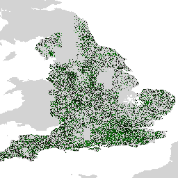
The Farmscapes 2020 dataset provides high-resolution probability maps for hedgerows, woodland, and stone walls in England's agricultural landscapes.
-
This dataset is intended for applications such as landscape restoration, biodiversity monitoring, and ecological connectivity analysis.
-
The dataset was generated using a vision transformer model applied to high-resolution aerial imagery.
-
Limitations include reduced performance in urban and mountainous areas, data temporal accuracy up to 2020, and lower accuracy for stone walls due to class imbalance.
-
An experimental European-scale version of the dataset is also available upon request.
- Catalog Owner
- Nature Trace
- Dataset Availability
- 2018-01-01T00:00:00Z–2020-12-31T23:59:59Z
- Dataset Provider
- Tags
Description
The Farmscapes 2020 dataset provides high-resolution (25cm) probability maps for three key semi-natural features within England's agricultural landscapes: hedgerows, woodland, and stone walls. This dataset was developed in collaboration with the Oxford Leverhulme Centre for Nature Recovery to serve as a baseline for applications including landscape restoration, biodiversity monitoring, and ecological connectivity analysis.
The dataset was generated by applying a vision transformer model to a mosaic of high-resolution aerial imagery, trained using a large corpus of human-annotated labels. The output consists of three distinct probability layers, one for each feature class. This probabilistic format allows users to apply custom thresholds to generate binary feature maps tailored to their specific analytical requirements.
Limitations
- Geographic Scope: Model performance is reduced in dense urban environments and montainous areas, which were underrepresented in the training data that focused primarily on rural landscapes.
- Temporal Accuracy: The source imagery was captured between 2018 and 2020. Consequently, the dataset does not account for landscape changes that have occurred since this period.
- Class-Specific performance: The stone wall class exhibits lower accuracy compared to woodland and hedgerows, a result of significant class imbalance in the training data.
Europe Dataset
In addition to the primary dataset for England, a preliminary version has been generated at a European scale. This dataset has not been subjected to the same quantitative validation and should be considered experimental. It is possible to request access to this dataset by submitting this form.
Bands
Pixel Size
0.25 meters
Bands
| Name | Min | Max | Scale | Pixel Size | Description |
|---|---|---|---|---|---|
B0 |
0 | 250 | 0.004 | meters | Hedgerow probability (scaled to [0-250]). |
B1 |
0 | 250 | 0.004 | meters | Stone wall probability (scaled to [0-250]). |
B2 |
0 | 250 | 0.004 | meters | Woodland/tree probability (scaled to [0-250]). |
Terms of Use
Terms of Use
This dataset is licensed under CC-BY 4.0 and requires the following attribution: "This dataset is produced by Google".
Citations
Michelangelo Conserva, Alex Wilson, Charlotte Stanton, Vishal Batchu, Varun Gulshan , "Mapping Farmed Landscapes from Remote Sensing" (in review). doi:10.48550/arXiv.2506.13993,
Explore with Earth Engine
Code Editor (JavaScript)
var farmscapes =
    ee.ImageCollection('projects/nature-trace/assets/farmscapes/england_v1_0')
        .mosaic();
Map.addLayer(farmscapes, {}, 'Raw probs', false);

var stone_wall = farmscapes.select(['B1']);
stone_wall = stone_wall.updateMask(stone_wall.gt(250 / 4));
Map.addLayer(
    stone_wall, {palette: ['FFFFFF', '00FFFF'], min: 0, max: 250},
    'Stone wall');

var hedgerow = farmscapes.select(['B0']);
hedgerow = hedgerow.updateMask(hedgerow.gt(250 / 4));
Map.addLayer(
    hedgerow, {palette: ['FFFFFF', 'c71585'], min: 0, max: 250}, 'Hedgerow');

var woodland = farmscapes.select(['B2']);
woodland = woodland.updateMask(woodland.gt(250 / 4));
Map.addLayer(
    woodland, {palette: ['FFFFFF', '06402B'], min: 0, max: 250}, 'Woodland');

var lon = -1.43;
var lat = 52.973;
Map.setCenter(lon, lat, 15);