- 카탈로그 소유자
- Awesome GEE Community Catalog
- 데이터 세트 제공
- 2022-01-26T00:00:00Z–2022-01-26T23:59:00Z
- 데이터 세트 제공업체
- 바흐람 카자에이
- 태그
설명
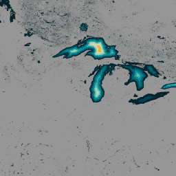
전 세계 140만 개 이상의 수역에 관한 데이터로 구성된 글로벌 수심 (GLOBathy) 데이터 세트는 널리 알려진 HydroLAKES 데이터 세트와 조화를 이루도록 세심하게 개발되었습니다. 정교한 지리 정보 시스템 (GIS) 기반 프레임워크를 활용하여 GLOBathy는 HydroLAKES에서 제공하는 최대 깊이 추정치와 기하학적/지구물리학적 속성을 통합하여 상세한 수심 지도를 구성합니다. 데이터 정확성과 신뢰성을 보장하기 위해 GLOBathy는 1,503개의 수역과 다양한 관측 데이터 소스를 포함하는 엄격한 검증 절차를 거칩니다. 따라서 GLOBathy는 수로학 및 수생 과학을 위한 강력하고 포괄적인 데이터 세트로서, 이 분야의 연구자와 전문가에게 귀중한 리소스를 제공합니다.
대역
픽셀 크기
30m
밴드
| 이름 | 단위 | 최소 | 최대 | 픽셀 크기 | 설명 |
|---|---|---|---|---|---|
b1 |
m | 0* | 1548.53* | 미터 | 최대 심도 |
이용약관
이용약관
데이터 세트는 CC0 1.0 범용 (CC0 1.0) 퍼블릭 도메인 제공에 따라 출시됩니다. 이 데이터 세트를 생성하고 자금을 지원하는 조직은 상품성 또는 특정 용도에 대한 적합성 보증을 포함하되 이에 국한되지 않는 어떠한 종류의 보증도 제공하지 않으며, 데이터와 관련하여 어떠한 보증도 묵시적으로 제공되지 않습니다.
인용
Khazaei, Bahram; Read, Laura K; Casali, Matthew; Sampson, Kevin M; Yates, David N (2022): GLOBathy Bathymetry Rasters. figshare. 데이터 세트. https://doi.org/10.6084/m9.figshare.c.5243309.v1
DOI
Earth Engine으로 탐색
코드 편집기(JavaScript)
var globathy = ee.Image(
  "projects/sat-io/open-datasets/GLOBathy/GLOBathy_bathymetry"
);

var palettes = require("users/samapriya/utils:palettes");

// Use these visualization parameters, customized by location.
var visParams = { min: 1, max: 700, palette: palettes.extra.blkred };

// Note that the visualization image doesn't require visualization parameters.
Map.addLayer(globathy, visParams, "Globathy Bathymetry (m)");