-
GLOBathy Global lakes bathymetry 데이터 세트
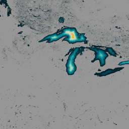
전 세계 140만 개 이상의 수역에 관한 데이터로 구성된 글로벌 수심 (GLOBathy) 데이터 세트는 널리 알려진 HydroLAKES 데이터 세트와 조화를 이루도록 세심하게 개발되었습니다. 정교한 지리 정보 시스템 (GIS) 기반 프레임워크를 활용하여 GLOBathy는 최대 깊이 추정치와 기하학적/지구물리학적 … bathymetry community-dataset hydrology sat-io surface-ground-water -
LandScan 인구 데이터 전 세계 1km
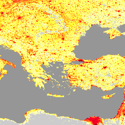
Oak Ridge National Laboratory (ORNL)에서 제공하는 LandScan 데이터 세트는 다양한 애플리케이션에 유용한 리소스로 활용되는 포괄적이고 고해상도의 전 세계 인구 분포 데이터 세트를 제공합니다. 최첨단 공간 모델링 기술과 고급 지리 공간 데이터 소스를 활용하는 LandScan은 상세한 … community-dataset demography landscan population sat-io -
미국 가뭄 모니터
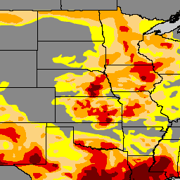
미국 가뭄 모니터는 매주 목요일에 발표되는 지도로, 가뭄이 발생한 미국 지역을 보여줍니다. 지도에서는 비정상적으로 건조한 지역(D0, 가뭄이 시작되거나 끝나는 지역을 표시)과 4단계의 가뭄(…) 등 5가지 분류를 사용합니다. community-dataset drought noaa precipitation sat-io usda
Datasets tagged sat-io in Earth Engine
[null,null,[],[],[]]