-
GRIDMET 가뭄: 미국 가뭄 지수

이 데이터 세트에는 4km 일일 격자화된 지표면 기상 (GRIDMET) 데이터 세트에서 파생된 가뭄 지수가 포함되어 있습니다. 제공되는 가뭄 지수에는 표준화된 강수 지수 (SPI), 증발 가뭄 수요 지수 (EDDI), 표준화된 강수 증발 지수 (SPEI), 파머 가뭄 지수 (PDSI) 및 파머 … 기후 미국 농작물 가뭄 증발 지구물리학 -
KBDI: 키치-바이람 가뭄 지수
키치-바이람 가뭄 지수 (KBDI)는 토양 및 부식토층의 건조도를 추정하기 위한 연속 참조 척도입니다. 이 지수는 비가 오지 않는 날마다 증가하고 (증가량은 일일 최고 기온에 따라 다름) 비가 오면 감소합니다. 이 시스템은 … 가뭄 화재 강우 -
SPEIbase: 표준화된 강수 증발 지수 데이터베이스, 버전 2.10
전역 SPEI 데이터베이스 (SPEIbase)는 0.5도 픽셀 크기와 월별 주기로 전역 규모의 가뭄 상태에 관한 장기적이고 강력한 정보를 제공합니다. 1~48개월의 SPEI 시간 척도를 제공합니다. 표준화된 강수 증발 지수 (SPEI)는 표준화된 변수로 … 기후 기후 변화 가뭄 증발 전역 월별 -
SPL3SMP_E.005 SMAP L3 방사계 전역 일일 9km 토양 수분
2023-12-04부터의 데이터는 NASA/SMAP/SPL3SMP_E/006 컬렉션에서 확인할 수 있습니다. 이 레벨 3 (L3) 토양 수분 제품은 토양 수분 능동 수동 (SMAP) L-대역 방사계에서 검색한 전역 지표면 상태의 일일 합성 데이터를 제공합니다. 여기서 일일 데이터는 하강 (현지 … 가뭄 NASA SMAP 토양 토양 수분 표면 -
SPL3SMP_E.006 SMAP L3 방사계 전역 일일 9km 토양 수분

2023-12-04 이전의 데이터는 이전 NASA/SMAP/SPL3SMP_E/005 컬렉션에서 확인할 수 있습니다. 이 데이터는 결국 재처리되어 이 컬렉션에 추가될 예정입니다. 이 레벨 3 (L3) 토양 수분 제품은 토양 수분 능동 수동 (SMAP) L-대역 … 가뭄 NASA SMAP 토양 토양 수분 표면 -
SPL4SMGP.008 SMAP L4 전역 3시간 9km 지표면 및 근권 토양 수분

SMAP 레벨 4 (L4) 토양 수분 제품에는 지표면 토양 수분 (0~5cm 수직 평균), 근권 토양 수분 (0~100cm 수직 평균), 지표면 기상 강제 변수, 토양 온도, 증발, 순 복사열을 비롯한 추가 연구 제품 (검증되지 않음)이 포함됩니다. 이 데이터 세트는 공식적으로 … 가뭄 NASA SMAP 토양 토양 수분 표면 -
TerraClimate: 전역 지표면의 월별 기후 및 기후 수분 균형, 아이다호 대학교

TerraClimate는 전역 지표면의 월별 기후 및 기후 수분 균형 데이터 세트입니다. 기후적으로 지원되는 보간법을 사용하여 WorldClim 데이터 세트의 높은 공간 해상도 기후학적 표준과 CRU Ts4.0 및 일본 55년 재분석 (JRA55)의 더 낮은 공간 해상도이지만 시간 변화 데이터를 결합합니다. … 기후 가뭄 증발 지구물리학 전역 머시드 -
미국 가뭄 모니터
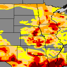
미국 가뭄 모니터는 매주 목요일에 발표되는 지도로, 가뭄이 발생한 미국 지역을 보여줍니다. 이 지도에서는 5가지 분류를 사용합니다. 비정상적으로 건조한 (D0) 지역은 가뭄이 시작되거나 가뭄에서 벗어나는 지역을 보여주며, 4가지 수준의 가뭄은 … 커뮤니티 데이터 세트 가뭄 NOAA 강수량 Sat-io USDA
Datasets tagged drought in Earth Engine
[null,null,[],[],["The provided data includes several datasets related to drought and soil conditions. SPEIbase offers global drought information with monthly updates and varying time scales. GRIDMET DROUGHT provides various drought indices, including SPI and SPEI, for the US. TerraClimate offers monthly global climate and water balance data. SMAP datasets (SPL3SMP_E and SPL4SMGP) detail daily and 3-hourly soil moisture, while KBDI estimates soil dryness. The US Drought Monitor weekly maps US areas affected by drought, classifying them into different drought levels.\n"]]