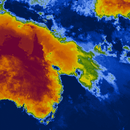
Keetch-Byram 가뭄 지수 (KBDI)는 토양 및 부식층의 건조도를 추정하기 위한 연속 참조 척도입니다. 비가 오지 않는 날마다 지수가 증가하며 (증가량은 일일 최고 기온에 따라 다름) 비가 오면 감소합니다. 이 시스템은 주로 최근 강우 패턴을 기반으로 합니다. 기상학적 가뭄을 측정하는 지표로, 토양 내 수분 증가 또는 감소를 반영합니다.
범위는 0 (수분 부족 없음)에서 800 (극심한 가뭄)까지입니다. 지수의 범위는 식물이 쉽게 이용할 수 있는 포화 토양에 20cm의 수분이 있다고 가정하여 결정됩니다 (Keetch and Byram, 1968). KBDI는 전 세계적으로 국가 날씨 예보, 산불 예방, 특히 강수량에 의존하는 작물이 있는 지역에서 유용하게 가뭄 모니터링에 사용됩니다.
Wataru Takeuchi, Soni Darmawan, Rizatus Shofiyati, Mai Van Khiem, Kyaw San Oo, Uday Pimple
and Suthy Heng, 2015. 아시아 농경지의 거의 실시간 기상학적 가뭄 모니터링 및 조기 경보 시스템
36th Asian conference on remote sensing (ACRS): Manila, Philippines, Oct. 20, 2015.
[null,null,[],[[["\u003cp\u003eThe Keetch-Byram Drought Index (KBDI) dataset provides a continuous scale (0-800) for estimating the dryness of soil and duff layers, reflecting recent rainfall patterns and meteorological drought.\u003c/p\u003e\n"],["\u003cp\u003eKBDI values increase daily without rain (influenced by temperature) and decrease with rainfall, offering insights into soil moisture deficits.\u003c/p\u003e\n"],["\u003cp\u003eThis dataset, available from 2007-01-01 to 2024-12-11, is valuable for drought monitoring, wildfire prevention, and agricultural planning, especially in rain-fed regions.\u003c/p\u003e\n"],["\u003cp\u003eProvided by the Institute of Industrial Science at the University of Tokyo, the dataset is accessible through Google Earth Engine with a resolution of 4000 meters.\u003c/p\u003e\n"],["\u003cp\u003eLicensed under CC-BY-4.0, the KBDI dataset encourages research, education, and non-profit use for drought analysis and applications.\u003c/p\u003e\n"]]],["The dataset provides the Keetch-Byram Drought Index (KBDI), a measure of soil and duff layer dryness, ranging from 0 (no deficit) to 800 (extreme drought). The index increases during dry periods and decreases with rainfall, reflecting meteorological drought conditions. The data, provided by the University of Tokyo, is updated daily from 2007-01-01 to 2025-02-21 and is available via Google Earth Engine. Pixel size is 4000 meters. It is tagged for drought and rainfall.\n"],null,["Dataset Availability\n: 2007-01-01T00:00:00Z--2025-08-26T00:00:00Z\n\nDataset Provider\n:\n\n\n [Institute of Industrial Science, The University of Tokyo, Japan](http://wtlab.iis.u-tokyo.ac.jp/DMEWS/)\n\nCadence\n: 1 Day\n\nTags\n:\n [drought](/earth-engine/datasets/tags/drought) [fire](/earth-engine/datasets/tags/fire) [rainfall](/earth-engine/datasets/tags/rainfall) \n kbdi \n lst-derived \n utokyo \nwtlab \n\nDescription \nKeetch-Byram Drought Index (KBDI) is a continuous reference scale for estimating the dryness of\nthe soil and duff layers. The index increases for each day without rain (the amount of increase\ndepends on the daily high temperature) and decreases when it rains. This system is based\nprimarily on recent rainfall patterns. It is a measure of meteorological drought; it reflects\nwater gain or loss within the soil.\n\nThe scale ranges from 0 (no moisture deficit) to 800 (extreme drought). The range of the index\nis determined by assuming that there is 20 cm of moisture in a saturated soil that is readily\navailable to the vegetation (Keetch and Byram, 1968). KBDI is world widely used for drought\nmonitoring for national weather forecast, wildfire prevention and usefully especially in regions\nwith rain-fed crops.\n\nBands\n\n\n**Pixel Size**\n\n4000 meters\n\n**Bands**\n\n| Name | Min | Max | Pixel Size | Description |\n|--------|-----|-----|------------|----------------------------|\n| `KBDI` | 0 | 800 | meters | Keetch-Byram Drought Index |\n\nTerms of Use\n\n**Terms of Use**\n\n[CC-BY-4.0](https://spdx.org/licenses/CC-BY-4.0.html)\n\nCitations \nCitations:\n\n- Wataru Takeuchi, Soni Darmawan, Rizatus Shofiyati, Mai Van Khiem, Kyaw San Oo, Uday Pimple\n and Suthy Heng, 2015. Near-real time meteorological drought monitoring and early warning\n system for croplands in Asia.\n 36th Asian conference on remote sensing (ACRS): Manila, Philippines, Oct. 20, 2015.\n\nExplore with Earth Engine **Important:** Earth Engine is a platform for petabyte-scale scientific analysis and visualization of geospatial datasets, both for public benefit and for business and government users. Earth Engine is free to use for research, education, and nonprofit use. To get started, please [register for Earth Engine access.](https://console.cloud.google.com/earth-engine)\n\nCode Editor (JavaScript) \n\n```javascript\nvar collection = ee.ImageCollection('UTOKYO/WTLAB/KBDI/v1')\n .select('KBDI')\n .filterDate('2019-01-01', '2019-01-10');\nvar bandViz = {\n min: 0,\n max: 800,\n palette: [\n '001a4d', '003cb3', '80aaff', '336600', 'cccc00', 'cc9900', 'cc6600',\n '660033'\n ]\n};\nMap.addLayer(collection.mean(), bandViz, 'Keetch-Byram Drought Index');\nMap.setCenter(120, 3, 3);\n```\n[Open in Code Editor](https://code.earthengine.google.com/?scriptPath=Examples:Datasets/UTOKYO/UTOKYO_WTLAB_KBDI_v1) \n[KBDI: Keetch-Byram Drought Index](/earth-engine/datasets/catalog/UTOKYO_WTLAB_KBDI_v1) \nKeetch-Byram Drought Index (KBDI) is a continuous reference scale for estimating the dryness of the soil and duff layers. The index increases for each day without rain (the amount of increase depends on the daily high temperature) and decreases when it rains. This system is based primarily on recent rainfall ... \nUTOKYO/WTLAB/KBDI/v1, drought,fire,rainfall \n2007-01-01T00:00:00Z/2025-08-26T00:00:00Z \n-60 60 60 180 \nGoogle Earth Engine \nhttps://developers.google.com/earth-engine/datasets\n\n- [](https://doi.org/http://wtlab.iis.u-tokyo.ac.jp/DMEWS/)\n- [](https://doi.org/https://developers.google.com/earth-engine/datasets/catalog/UTOKYO_WTLAB_KBDI_v1)"]]