- Właściciel katalogu
- Awesome GEE Community Catalog
- Dostępność zbioru danych
- 2022-01-26T00:00:00Z–2022-01-26T23:59:00Z
- Dostawca zbioru danych
- Bahram Khazaei
- Tagi
Opis
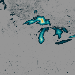
Zbiór danych GLObal Bathymetric (GLOBathy), który zawiera informacje o ponad 1,4 mln zbiorników wodnych na całym świecie, został starannie opracowany, aby był zgodny z powszechnie uznawanym zbiorem danych HydroLAKES. GLOBathy wykorzystuje zaawansowany system informacji geograficznej (GIS) do tworzenia szczegółowych map batymetrycznych. Integruje szacunki maksymalnej głębokości oraz atrybuty geometryczne i geofizyczne pochodzące z HydroLAKES. Aby zapewnić dokładność i wiarygodność danych, GLOBathy przechodzi rygorystyczne procedury weryfikacji obejmujące 1503 zbiorniki wodne i różnorodne źródła danych obserwacyjnych. Dzięki temu GLOBathy jest solidnym i wszechstronnym zbiorem danych dla hydrologii i nauk o wodzie, który stanowi nieocenione źródło informacji dla badaczy i specjalistów z tych dziedzin.
Pasma
Rozmiar piksela
30 metrów
Pasma
| Nazwa | Jednostki | Min. | Maksimum | Rozmiar piksela | Opis |
|---|---|---|---|---|---|
b1 |
m | 0* | 1548,53* | metry | Maksymalna głębokość |
Warunki usługi
Warunki usługi
Zbiór danych jest udostępniany na podstawie licencji CC0 1.0 Universal (CC0 1.0) Public Domain Dedication. Organizacje odpowiedzialne za generowanie i finansowanie tego zbioru danych nie składają żadnych oświadczeń, w tym między innymi oświadczeń dotyczących wartości handlowej lub przydatności do określonego celu, ani nie udzielają żadnych gwarancji w odniesieniu do danych.
Cytaty
Khazaei, Bahram; Read, Laura K; Casali, Matthew; Sampson, Kevin M; Yates, David N (2022): GLOBathy Bathymetry Rasters. figshare. Dataset. https://doi.org/10.6084/m9.figshare.c.5243309.v1
DOI
Odkrywanie za pomocą Earth Engine
Edytor kodu (JavaScript)
var globathy = ee.Image(
  "projects/sat-io/open-datasets/GLOBathy/GLOBathy_bathymetry"
);

var palettes = require("users/samapriya/utils:palettes");

// Use these visualization parameters, customized by location.
var visParams = { min: 1, max: 700, palette: palettes.extra.blkred };

// Note that the visualization image doesn't require visualization parameters.
Map.addLayer(globathy, visParams, "Globathy Bathymetry (m)");