-
Zbiór danych batymetrycznych jezior na całym świecie GLOBathy
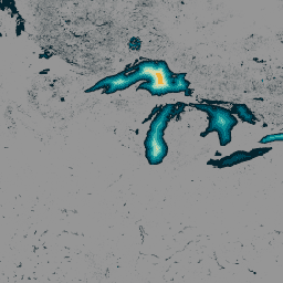
Zbiór danych GLObal Bathymetric (GLOBathy), który zawiera informacje o ponad 1,4 mln zbiorników wodnych na całym świecie, został starannie opracowany, aby był zgodny z powszechnie uznawanym zbiorem danych HydroLAKES. GLOBathy wykorzystuje zaawansowany system informacji geograficznej (GIS) do tworzenia szczegółowych map batymetrycznych poprzez integrację szacunków maksymalnej głębokości oraz danych geometrycznych i geofizycznych. batymetria zbiór danych społeczności hydrologia sat-io wody podziemne powierzchniowe -
Dane o populacji LandScan na całym świecie w siatce 1 km
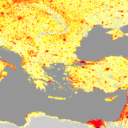
Zbiór danych LandScan, udostępniany przez Oak Ridge National Laboratory (ORNL), to kompleksowy zbiór danych o rozmieszczeniu ludności na świecie o wysokiej rozdzielczości, który stanowi cenne źródło informacji dla wielu zastosowań. LandScan wykorzystuje najnowocześniejsze techniki modelowania przestrzennego i zaawansowane źródła danych geoprzestrzennych, aby dostarczać szczegółowe informacje o … community-dataset demography landscan population sat-io -
United States Drought Monitor

U.S. Drought Monitor to mapa publikowana w każdy czwartek, która pokazuje obszary Stanów Zjednoczonych dotknięte suszą. Mapa korzysta z 5 klasyfikacji: nienormalnie sucho (D0), czyli obszary, które mogą wchodzić w okres suszy lub z niego wychodzić, oraz 4 poziomy suszy: … community-dataset drought noaa precipitation sat-io usda
Datasets tagged sat-io in Earth Engine
[null,null,[],[],[]]