-
Classification mondiale des forêts pour 2020 pour les estimations de niveau 1 de la biomasse aérienne du GIEC, V1

Cet ensemble de données fournit des classes de forêts mondiales délimitées par état/condition en 2020 à une résolution d'environ 30 m. Les données permettent de générer des estimations de niveau 1 pour la densité de biomasse ligneuse sèche aérienne dans les forêts naturelles dans le cadre de l'affinement de 2019 des directives du GIEC de 2006 pour les inventaires nationaux de gaz à effet de serre. aboveground biomass carbon classification forest forest-biomass -
Cartes mondiales de la densité de carbone de la biomasse aérienne et souterraine

Cet ensemble de données fournit des cartes mondiales cohérentes et harmonisées dans le temps de la densité de carbone de la biomasse aérienne et souterraine pour l'année 2010 à une résolution spatiale de 300 m. La carte de la biomasse aérienne intègre des cartes de télédétection spécifiques à la couverture terrestre de la biomasse ligneuse, des prairies, des terres cultivées et de la toundra. Les cartes d'entrée étaient … aboveground biomass carbon density forest forest-biomass -
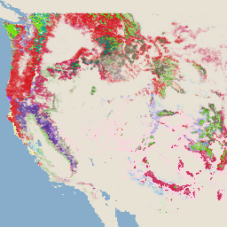
USFS TreeMap v2020

Ce produit fait partie de la suite de données TreeMap. Il fournit des informations spatiales détaillées sur les caractéristiques des forêts, y compris le nombre d'arbres vivants et morts, la biomasse et le carbone sur l'ensemble de la superficie forestière des États-Unis en 2020. TreeMap v2020 contient 22 bandes de 30 x 30 m … aboveground biomass carbon climate-change conus forest -
USFS TreeMap v2022
Ce produit fait partie de la suite de données TreeMap. Il fournit des informations spatiales détaillées sur les caractéristiques des forêts, y compris le nombre d'arbres vivants et morts, la biomasse et le carbone sur l'ensemble de la superficie forestière des États-Unis en 2022. TreeMap v2022 contient 22 bandes de 30 x 30 m … aboveground biomass carbon climate-change conus forest -
Ensemble de données sur le stock de carbone au niveau national pantropical du WHRC

Carte au niveau national de la densité de biomasse ligneuse vivante aérienne pour les pays tropicaux à 500 m. Cet ensemble de données a été assemblé à partir d'une combinaison de mesures sur le terrain, d'observations LiDAR et d'images enregistrées par le spectroradiomètre imageur à résolution modérée (MODIS). aboveground biomass carbon forest-biomass geophysical umd
Datasets tagged aboveground in Earth Engine
[null,null,[],[],[]]