-
열대 우림 모니터링을 위한 NICFI 위성 데이터 프로그램 베이스맵 - 아프리카
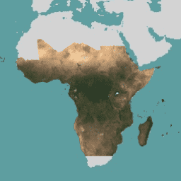
이 이미지 컬렉션은 열대 우림 손실을 줄이고 되돌리는 것을 주 목적으로 열대 지방의 고해상도 위성 모니터링에 대한 액세스를 제공하여 기후 변화에 대처하고, 생물 다양성을 보존하고, 산림 재생, 복원 및 개선에 기여하고, 지속 가능한 개발을 촉진합니다. 모든 … 베이스맵 산림 nicfi planet planet-nicfi publisher-dataset -
열대 우림 모니터링을 위한 NICFI 위성 데이터 프로그램 베이스맵 - 아메리카
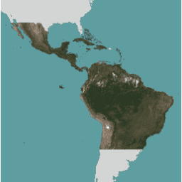
이 이미지 컬렉션은 열대 우림 손실을 줄이고 되돌리는 것을 주 목적으로 열대 지방의 고해상도 위성 모니터링에 대한 액세스를 제공하여 기후 변화에 대처하고, 생물 다양성을 보존하고, 산림 재생, 복원 및 개선에 기여하고, 지속 가능한 개발을 촉진합니다. 모든 … 베이스맵 산림 nicfi planet planet-nicfi publisher-dataset -
열대 우림 모니터링을 위한 NICFI 위성 데이터 프로그램 베이스맵 - 아시아

이 이미지 컬렉션은 열대 우림 손실을 줄이고 되돌리는 것을 주 목적으로 열대 지방의 고해상도 위성 모니터링에 대한 액세스를 제공하여 기후 변화에 대처하고, 생물 다양성을 보존하고, 산림 재생, 복원 및 개선에 기여하고, 지속 가능한 개발을 촉진합니다. 모든 … 베이스맵 산림 nicfi planet planet-nicfi publisher-dataset
Datasets tagged basemaps in Earth Engine
[null,null,[],[],["High-resolution satellite imagery is available for monitoring tropical forests across Africa, the Americas, and Asia. The data is aimed at reducing tropical forest loss and combating climate change. It also aids in biodiversity conservation, forest regrowth, restoration, and sustainable development. This program, known as NICFI, provides access to satellite data from Planet, identified as planet-nicfi, to achieve these goals. These resources are considered as basemaps.\n"]]