-
מפת כיסוי השטח של חוף השנהב BNETD 2020
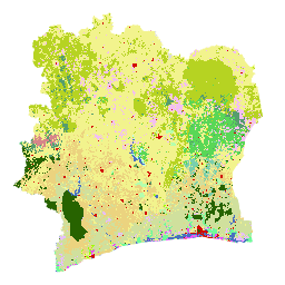
מפת כיסוי השטח של חוף השנהב BNETD לשנת 2020 נוצרה על ידי ממשלת חוף השנהב באמצעות מוסד לאומי, Center for Geographic Information and Digital from the National Study Office Techniques and Development (BNETD-CIGN), בתמיכה טכנית ופיננסית של האיחוד האירופי. המתודולוגיה … classification deforestation forest landcover landuse-landcover -
Global 2020 Forest Classification for IPCC Aboveground Biomass Tier 1 Estimates, V1

קבוצת הנתונים הזו מספקת סיווג של יערות גלובליים לפי סטטוס/מצב בשנת 2020 ברזולוציה של כ-30 מ'. הנתונים תומכים ביצירת אומדנים ברמה 1 של צפיפות ביומסה יבשה מעל פני הקרקע (AGBD) ביערות טבעיים ב-2019 Refinement to the 2006 IPCC Guidelines for National Greenhouse … aboveground biomass carbon classification forest forest-biomass -
מפה גלובלית של יערות ולא יערות עם 3 סיווגים של PALSAR-2/PALSAR

גרסה חדשה יותר של קבוצת הנתונים הזו עם 4 סיווגים לשנים 2017-2020 זמינה ב-JAXA/ALOS/PALSAR/YEARLY/FNF4. מפת היערות/שטחים ללא יערות (FNF) הגלובלית נוצרת על ידי סיווג תמונת ה-SAR (מקדם פיזור לאחור) בפסיפס ה-SAR של PALSAR-2/PALSAR ברזולוציה גלובלית של 25 מ', כך שפיקסלים עם פיזור לאחור חזק ונמוך … alos alos2 classification eroc forest forest-biomass -
מפה גלובלית של יערות ולא יערות עם 4 סוגים של נתונים מ-PALSAR-2/PALSAR

מפת היערות/לא יערות (FNF) הגלובלית נוצרת על ידי סיווג תמונת ה-SAR (מקדם פיזור לאחור) בפסיפס ה-SAR הגלובלי PALSAR-2/PALSAR ברזולוציה של 25 מ', כך שפיקסלים עם פיזור לאחור חזק וחלש מוקצים כ'יער' ו'לא יער', בהתאמה. כאן, 'יער' מוגדר כיער טבעי עם … alos alos2 classification eroc forest forest-biomass
Datasets tagged classification in Earth Engine
[null,null,[],[],[]]