-
आइवरी कोस्ट BNETD 2020 लैंड कवर मैप
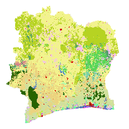
कोट डी आइवर के BNETD 2020 लैंड कवर मैप को, इवोरियन सरकार ने एक राष्ट्रीय संस्थान, सेंटर फ़ॉर जियोग्राफ़िक इन्फ़ॉर्मेशन ऐंड डिजिटल से तैयार किया था. यह संस्थान, नैशनल स्टडी ऑफ़िस टेक्निक ऐंड डेवलपमेंट (BNETD-CIGN) का हिस्सा है. इस मैप को तैयार करने में, यूरोपीय संघ ने तकनीकी और वित्तीय सहायता दी थी. मेथडोलॉजी … क्लासिफ़िकेशन जंगलों की कटाई जंगल भूमि का ढकाव भूमि के इस्तेमाल-भूमि का ढकाव -
IPCC के ऊपरी हिस्से के बायोमास के टियर 1 के अनुमान के लिए, ग्लोबल 2020 फ़ॉरेस्ट क्लासिफ़िकेशन, V1
इस डेटासेट में, दुनिया भर के जंगलों की क्लास दी गई है. इन क्लास को 2020 में जंगलों की स्थिति/हालत के हिसाब से बांटा गया है. साथ ही, इनका रिज़ॉल्यूशन करीब 30 मीटर है. इस डेटा से, नेशनल ग्रीनहाउस गैसों के लिए 2006 के आईपीसीसी दिशा-निर्देशों में 2019 में किए गए बदलावों के तहत, प्राकृतिक जंगलों में जमीन से ऊपर के सूखे लकड़ी वाले बायोमास घनत्व (एजीबीडी) के लिए टीयर 1 के अनुमान जनरेट करने में मदद मिलती है … जमीन के ऊपर बायोमास कार्बन क्लासिफ़िकेशन फ़ॉरेस्ट फ़ॉरेस्ट-बायोमास -
ग्लोबल 3-क्लास PALSAR-2/PALSAR फ़ॉरेस्ट/नॉन-फ़ॉरेस्ट मैप
JAXA/ALOS/PALSAR/YEARLY/FNF4 में, 2017-2020 के लिए चार क्लास वाला इस डेटासेट का नया वर्शन देखा जा सकता है. ग्लोबल फ़ॉरेस्ट/नॉन-फ़ॉरेस्ट मैप (एफ़एनएफ़) को ग्लोबल 25 मीटर रिज़ॉल्यूशन वाले PALSAR-2/PALSAR SAR मोज़ेक में एसएआर इमेज (बैकस्कैटरिंग कोएफ़िशिएंट) को अलग-अलग कैटगरी में बांटकर जनरेट किया जाता है, ताकि ज़्यादा और कम बैकस्कैटर पिक्सल … alos alos2 classification eroc forest forest-biomass -
ग्लोबल 4-क्लास PALSAR-2/PALSAR फ़ॉरेस्ट/नॉन-फ़ॉरेस्ट मैप
दुनिया भर के जंगल/बिना जंगल वाले इलाके का नक्शा (एफ़एनएफ़), 25 मीटर के रिज़ॉल्यूशन वाले PALSAR-2/PALSAR एसएआर मोज़ेक में एसएआर इमेज (बैकस्कैटरिंग कोएफ़िशिएंट) को अलग-अलग कैटगरी में बांटकर जनरेट किया जाता है. इससे, ज़्यादा और कम बैकस्कैटर पिक्सल को "जंगल" और "बिना जंगल" के तौर पर असाइन किया जाता है. यहां, "जंगल" का मतलब ऐसे प्राकृतिक जंगल से है जिसमें … alos alos2 classification eroc forest forest-biomass
Datasets tagged classification in Earth Engine
[null,null,[],[[["\u003cp\u003eThe webpage provides access to various global and regional forest classification datasets.\u003c/p\u003e\n"],["\u003cp\u003eDatasets include land cover maps, forest/non-forest classifications, and biomass estimations.\u003c/p\u003e\n"],["\u003cp\u003eData sources include satellite imagery from PALSAR-2/PALSAR and organizations like BNETD and NASA.\u003c/p\u003e\n"],["\u003cp\u003eThese datasets support research on deforestation, forest monitoring, and carbon stock assessments.\u003c/p\u003e\n"],["\u003cp\u003eUsers can leverage these resources to analyze forest cover change and contribute to environmental studies.\u003c/p\u003e\n"]]],[],null,["# Datasets tagged classification in Earth Engine\n\n-\n\n |--------------------------------------------------------------------------------------------------------------------------------------------------------------------------------------------------------------------------------------------------------------------------------------------------------------------------------|\n | [### Cote d'Ivoire BNETD 2020 Land Cover Map](/earth-engine/datasets/catalog/BNETD_land_cover_v1) |\n | The Cote d'Ivoire BNETD 2020 Land Cover Map was produced by the Ivorian Government through a national institution, the Center for Geographic Information and Digital from the National Study Office Techniques and Development (BNETD-CIGN), with technical and financial support from the European Union. The methodology ... |\n | [classification](/earth-engine/datasets/tags/classification) [deforestation](/earth-engine/datasets/tags/deforestation) [forest](/earth-engine/datasets/tags/forest) [landcover](/earth-engine/datasets/tags/landcover) [landuse-landcover](/earth-engine/datasets/tags/landuse-landcover) |\n\n-\n\n |---------------------------------------------------------------------------------------------------------------------------------------------------------------------------------------------------------------------------------------------------------------------------------------------------------------------------|\n | [### Global 2020 Forest Classification for IPCC Aboveground Biomass Tier 1 Estimates, V1](/earth-engine/datasets/catalog/NASA_ORNL_global_forest_classification_2020_V1) |\n | This dataset provides classes of global forests delineated by status/condition in 2020 at approximately 30m resolution. The data support generating Tier 1 estimates for Aboveground dry woody Biomass Density (AGBD) in natural forests in the 2019 Refinement to the 2006 IPCC Guidelines for National Greenhouse ... |\n | [aboveground](/earth-engine/datasets/tags/aboveground) [biomass](/earth-engine/datasets/tags/biomass) [carbon](/earth-engine/datasets/tags/carbon) [classification](/earth-engine/datasets/tags/classification) [forest](/earth-engine/datasets/tags/forest) [forest-biomass](/earth-engine/datasets/tags/forest-biomass) |\n\n-\n\n |-------------------------------------------------------------------------------------------------------------------------------------------------------------------------------------------------------------------------------------------------------------------------------------------------------------------------------|\n | [### Global 3-class PALSAR-2/PALSAR Forest/Non-Forest Map](/earth-engine/datasets/catalog/JAXA_ALOS_PALSAR_YEARLY_FNF) |\n | A newer version of this dataset with 4 classes for 2017-2020 can be found in JAXA/ALOS/PALSAR/YEARLY/FNF4 The global forest/non-forest map (FNF) is generated by classifying the SAR image (backscattering coefficient) in the global 25m resolution PALSAR-2/PALSAR SAR mosaic so that strong and low backscatter pixels ... |\n | [alos](/earth-engine/datasets/tags/alos) [alos2](/earth-engine/datasets/tags/alos2) [classification](/earth-engine/datasets/tags/classification) [eroc](/earth-engine/datasets/tags/eroc) [forest](/earth-engine/datasets/tags/forest) [forest-biomass](/earth-engine/datasets/tags/forest-biomass) |\n\n-\n\n |-----------------------------------------------------------------------------------------------------------------------------------------------------------------------------------------------------------------------------------------------------------------------------------------------------------------------------------|\n | [### Global 4-class PALSAR-2/PALSAR Forest/Non-Forest Map](/earth-engine/datasets/catalog/JAXA_ALOS_PALSAR_YEARLY_FNF4) |\n | The global forest/non-forest map (FNF) is generated by classifying the SAR image (backscattering coefficient) in the global 25m resolution PALSAR-2/PALSAR SAR mosaic so that strong and low backscatter pixels are assigned as \"forest\" and \"non-forest\", respectively. Here, \"forest\" is defined as the natural forest with ... |\n | [alos](/earth-engine/datasets/tags/alos) [alos2](/earth-engine/datasets/tags/alos2) [classification](/earth-engine/datasets/tags/classification) [eroc](/earth-engine/datasets/tags/eroc) [forest](/earth-engine/datasets/tags/forest) [forest-biomass](/earth-engine/datasets/tags/forest-biomass) |"]]