-
FAO GAUL 500m Simplified: Global Administrative Unit Layers 2015, Second-Level Administrative Units
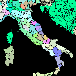
Ta wersja zbioru danych GAUL jest uproszczona do 500 m. Baza danych Global Administrative Unit Layers (GAUL) zawiera i rozpowszechnia najlepsze dostępne informacje o jednostkach administracyjnych we wszystkich krajach świata, przyczyniając się do standaryzacji zbioru danych przestrzennych reprezentujących jednostki administracyjne. … borders county districts fao gaul infrastructure-boundaries -
FAO GAUL: Global Administrative Unit Layers 2015, Second-Level Administrative Units

Baza danych Global Administrative Unit Layers (GAUL) zawiera i rozpowszechnia najlepsze dostępne informacje o jednostkach administracyjnych we wszystkich krajach świata, przyczyniając się do standaryzacji zbioru danych przestrzennych reprezentujących jednostki administracyjne. GAUL zawsze zawiera warstwy globalne z ujednoliconym… borders county districts fao gaul infrastructure-boundaries
Datasets tagged districts in Earth Engine
[null,null,[],[],["The Global Administrative Unit Layers (GAUL) dataset compiles and disseminates information on administrative units for all countries, aiding in the standardization of spatial datasets representing these units. Two versions are available: GAUL 2015 (second-level units) and a simplified 500m version. Both provide global layers and are related to administrative borders, counties, and districts. These datasets are made available by the FAO.\n"]]