-
FAO GAUL 500m Simplified: Global Administrative Unit Layers 2015, Country Boundaries

Ta wersja zbioru danych GAUL jest uproszczona do 500 m. Baza danych Global Administrative Unit Layers (GAUL) zawiera i rozpowszechnia najlepsze dostępne informacje o jednostkach administracyjnych we wszystkich krajach świata, przyczyniając się do standaryzacji zbioru danych przestrzennych reprezentujących jednostki administracyjne. … borders countries fao gaul infrastructure-boundaries table -
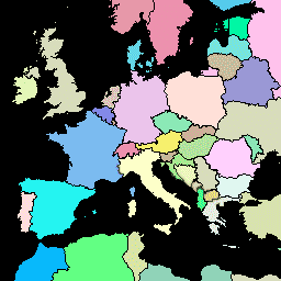
FAO GAUL 500m Simplified: Global Administrative Unit Layers 2015, First-Level Administrative Units

Ta wersja zbioru danych GAUL jest uproszczona do 500 m. Baza danych Global Administrative Unit Layers (GAUL) zawiera i rozpowszechnia najlepsze dostępne informacje o jednostkach administracyjnych we wszystkich krajach świata, przyczyniając się do standaryzacji zbioru danych przestrzennych reprezentujących jednostki administracyjne. … borders departments fao gaul infrastructure-boundaries provinces -
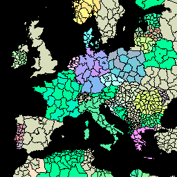
FAO GAUL 500m Simplified: Global Administrative Unit Layers 2015, Second-Level Administrative Units
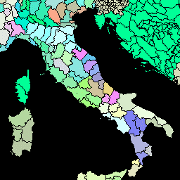
Ta wersja zbioru danych GAUL jest uproszczona do 500 m. Baza danych Global Administrative Unit Layers (GAUL) zawiera i rozpowszechnia najlepsze dostępne informacje o jednostkach administracyjnych we wszystkich krajach świata, przyczyniając się do standaryzacji zbioru danych przestrzennych reprezentujących jednostki administracyjne. … borders county districts fao gaul infrastructure-boundaries -
FAO GAUL: Global Administrative Unit Layers 2015, Country Boundaries
Baza danych Global Administrative Unit Layers (GAUL) zawiera i rozpowszechnia najlepsze dostępne informacje o jednostkach administracyjnych we wszystkich krajach świata, przyczyniając się do standaryzacji zbioru danych przestrzennych reprezentujących jednostki administracyjne. GAUL zawsze zawiera warstwy globalne z ujednoliconym… borders countries fao gaul infrastructure-boundaries table -
FAO GAUL: Global Administrative Unit Layers 2015, First-Level Administrative Units
Baza danych Global Administrative Unit Layers (GAUL) zawiera i rozpowszechnia najlepsze dostępne informacje o jednostkach administracyjnych we wszystkich krajach świata, przyczyniając się do standaryzacji zbioru danych przestrzennych reprezentujących jednostki administracyjne. GAUL zawsze zawiera warstwy globalne z ujednoliconym… borders departments fao gaul infrastructure-boundaries provinces -
FAO GAUL: Global Administrative Unit Layers 2015, Second-Level Administrative Units

Baza danych Global Administrative Unit Layers (GAUL) zawiera i rozpowszechnia najlepsze dostępne informacje o jednostkach administracyjnych we wszystkich krajach świata, przyczyniając się do standaryzacji zbioru danych przestrzennych reprezentujących jednostki administracyjne. GAUL zawsze zawiera warstwy globalne z ujednoliconym… borders county districts fao gaul infrastructure-boundaries
Datasets tagged gaul in Earth Engine
[null,null,[],[],[]]