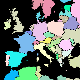
Global Administrative Unit Layers (GAUL) gromadzi i rozpowszechnia najlepsze dostępne informacje o jednostkach administracyjnych we wszystkich krajach świata, przyczyniając się do standaryzacji przestrzennego zbioru danych reprezentującego jednostki administracyjne. GAUL zawsze zawiera warstwy globalne z ujednoliconym systemem kodowania na poziomie kraju oraz na poziomie jednostek administracyjnych pierwszego (np. departamentów) i drugiego rzędu (np. okręgów). Jeśli dane są dostępne, zawiera warstwy dla poszczególnych krajów aż do trzeciego, czwartego i niższych poziomów. Ogólna metodologia polega na: a) zbieraniu najlepszych dostępnych danych z najbardziej wiarygodnych źródeł, b) ustalaniu okresów weryfikacji cech geograficznych (w miarę możliwości), c) dodawaniu wybranych danych do warstwy globalnej na podstawie ostatniej mapy granic krajów dostarczonej przez Jednostkę Kartograficzną ONZ (UNCS), d) generowaniu kodów za pomocą systemu kodowania GAUL i e) dystrybuowaniu danych do użytkowników (patrz Aspekty techniczne zestawu dystrybucyjnego GAUL).
Pamiętaj, że niektóre jednostki administracyjne to obiekty wielokątne.
Schemat tabeli
Schemat tabeli
Nazwa
Typ
Opis
ADM0_CODE
PRZ
GAUL – kod kraju
ADM0_NAME
CIĄG ZNAKÓW
Nazwa kraju ONZ
DISP_AREA
CIĄG ZNAKÓW
Terytorium sporne: „Tak” lub „Nie”
STAN
CIĄG ZNAKÓW
Stan kraju
Shape_Area
LICZBA ZMIENNOPRZECINKOWA O PODWÓJNEJ PRECYZJI
Obszar kształtu
Shape_Leng
LICZBA ZMIENNOPRZECINKOWA O PODWÓJNEJ PRECYZJI
Długość kształtu
EXP0_YEAR
PRZ
Rok utraty ważności jednostki administracyjnej
STR0_YEAR
PRZ
Rok utworzenia jednostki administracyjnej
Warunki korzystania z usługi
Zbiór danych GAUL jest rozpowszechniany wśród Organizacji Narodów Zjednoczonych i innych upoważnionych instytucji i agencji międzynarodowych oraz krajowych. FAO udziela licencji na używanie, pobieranie i drukowanie materiałów zawartych w zbiorze danych GAUL wyłącznie do celów niekomercyjnych i zgodnie z warunkami określonymi w licencji na dane. Pełny dokument licencji GAUL Data License
można pobrać. Zobacz też wyłączenie odpowiedzialności.
Baza danych Global Administrative Unit Layers (GAUL) zawiera i rozpowszechnia najlepsze dostępne informacje o jednostkach administracyjnych we wszystkich krajach świata, przyczyniając się do standaryzacji zbioru danych przestrzennych reprezentujących jednostki administracyjne. GAUL zawsze zawiera warstwy globalne z ujednoliconym systemem kodowania na poziomie kraju, pierwszego poziomu administracyjnego…
[null,null,[],[[["\u003cp\u003eThe FAO GAUL dataset provides global administrative unit boundaries for all countries, standardized with a unified coding system.\u003c/p\u003e\n"],["\u003cp\u003eIt includes country, first (e.g., departments), and second (e.g., districts) administrative levels, with some countries having data down to lower levels.\u003c/p\u003e\n"],["\u003cp\u003eThe dataset is available for non-commercial use under the GAUL Data License, with specific terms and conditions detailed in the license document.\u003c/p\u003e\n"],["\u003cp\u003eUsers can access and analyze the dataset in Earth Engine using provided code snippets for visualization and exploration.\u003c/p\u003e\n"],["\u003cp\u003eThe data is sourced from reliable providers and undergoes validation processes to ensure accuracy and consistency.\u003c/p\u003e\n"]]],[],null,["# FAO GAUL: Global Administrative Unit Layers 2015, Country Boundaries\n\nDataset Availability\n: 2014-12-19T16:45:00Z--2014-12-19T16:45:00Z\n\nDataset Provider\n:\n\n\n [FAO UN](https://www.fao.org/geonetwork/srv/en/metadata.show?id=12691)\n\nTags\n:\n[borders](/earth-engine/datasets/tags/borders) [countries](/earth-engine/datasets/tags/countries) [fao](/earth-engine/datasets/tags/fao) [gaul](/earth-engine/datasets/tags/gaul) [infrastructure-boundaries](/earth-engine/datasets/tags/infrastructure-boundaries) [table](/earth-engine/datasets/tags/table) [un](/earth-engine/datasets/tags/un) \n\n#### Description\n\nThe Global Administrative Unit Layers (GAUL) compiles and disseminates the\nbest available information on administrative units for all the countries in\nthe world, providing a contribution to the standardization of the spatial\ndataset representing administrative units. The GAUL always maintains global\nlayers with a unified coding system at country, first (e.g. departments),\nand second administrative levels (e.g. districts). Where data is available,\nit provides layers on a country by country basis down to third, fourth, and\nlowers levels. The overall methodology consists in a) collecting the best\navailable data from most reliable sources, b) establishing validation\nperiods of the geographic features (when possible), c) adding selected data\nto the global layer based on the last country boundaries map provided by\nthe UN Cartographic Unit (UNCS), d) generating codes using GAUL Coding\nSystem, and e) distribute data to the users\n(see [Technical Aspects of the GAUL Distribution Set](https://data.apps.fao.org:/map/catalog/srv/api/records/9c35ba10-5649-41c8-bdfc-eb78e9e65654/attachments/GAUL2015_Documentation.zip).\nNote that some administrative units are multipolygon features.\n\n### Table Schema\n\n**Table Schema**\n\n| Name | Type | Description |\n|------------|--------|------------------------------------------|\n| ADM0_CODE | INT | GAUL country code |\n| ADM0_NAME | STRING | UN country name |\n| DISP_AREA | STRING | Unsettled territory: 'Yes' or 'No' |\n| STATUS | STRING | Status of the country |\n| Shape_Area | DOUBLE | Shape area |\n| Shape_Leng | DOUBLE | Shape length |\n| EXP0_YEAR | INT | Expiry year of the administrative unit |\n| STR0_YEAR | INT | Creation year of the administrative unit |\n\n### Terms of Use\n\n**Terms of Use**\n\nThe GAUL dataset is distributed to the United Nations and other authorized\ninternational and national institutions/agencies. FAO grants a license to\nuse, download and print the materials contained in the GAUL dataset solely\nfor non-commercial purposes and in accordance with the conditions specified\nin the data license. [The full GAUL Data License\ndocument](https://developers.google.com/earth-engine/datasets/catalog/DataLicenseGAUL2015.pdf)\nis available for downloading. See also [the\ndisclaimer](https://developers.google.com/earth-engine/datasets/catalog/DisclaimerGAUL2015.pdf).\n\n### Explore with Earth Engine\n\n| **Important:** Earth Engine is a platform for petabyte-scale scientific analysis and visualization of geospatial datasets, both for public benefit and for business and government users. Earth Engine is free to use for research, education, and nonprofit use. To get started, please [register for Earth Engine access.](https://console.cloud.google.com/earth-engine)\n\n### Code Editor (JavaScript)\n\n```javascript\nvar dataset = ee.FeatureCollection('FAO/GAUL/2015/level0');\n\nMap.setCenter(7.82, 49.1, 4);\n\nvar styleParams = {\n fillColor: 'b5ffb4',\n color: '00909F',\n width: 1.0,\n};\n\ndataset = dataset.style(styleParams);\n\nMap.addLayer(dataset, {}, 'Country Boundaries');\n```\n[Open in Code Editor](https://code.earthengine.google.com/?scriptPath=Examples:Datasets/FAO/FAO_GAUL_2015_level0)\n\n### Visualize as a FeatureView\n\n\nA `FeatureView` is a view-only, accelerated representation of a\n`FeatureCollection`. For more details, visit the\n[`FeatureView` documentation.](/earth-engine/guides/featureview_overview)\n| **Important:** Earth Engine is a platform for petabyte-scale scientific analysis and visualization of geospatial datasets, both for public benefit and for business and government users. Earth Engine is free to use for research, education, and nonprofit use. To get started, please [register for Earth Engine access.](https://console.cloud.google.com/earth-engine)\n\n### Code Editor (JavaScript)\n\n```javascript\nvar fvLayer = ui.Map.FeatureViewLayer('FAO/GAUL/2015/level0_FeatureView');\n\nvar visParams = {\n color: '00909F',\n fillColor: 'b5ffb4',\n opacity: 1,\n width: 1,\n pointSize: 1\n};\n\nfvLayer.setVisParams(visParams);\nfvLayer.setName('Country Boundaries');\n\nMap.setCenter(7.82, 49.1, 4);\nMap.add(fvLayer);\n```\n[Open in Code Editor](https://code.earthengine.google.com/?scriptPath=Examples:Datasets/FAO/FAO_GAUL_2015_level0_FeatureView) \n[FAO GAUL: Global Administrative Unit Layers 2015, Country Boundaries](/earth-engine/datasets/catalog/FAO_GAUL_2015_level0) \nThe Global Administrative Unit Layers (GAUL) compiles and disseminates the best available information on administrative units for all the countries in the world, providing a contribution to the standardization of the spatial dataset representing administrative units. The GAUL always maintains global layers with a unified coding system at country, first ... \nFAO/GAUL/2015/level0, borders,countries,fao,gaul,infrastructure-boundaries,table,un \n2014-12-19T16:45:00Z/2014-12-19T16:45:00Z \n-90 -180 90 180 \nGoogle Earth Engine \nhttps://developers.google.com/earth-engine/datasets\n\n- [](https://doi.org/https://www.fao.org/geonetwork/srv/en/metadata.show?id=12691)\n- [](https://doi.org/https://developers.google.com/earth-engine/datasets/catalog/FAO_GAUL_2015_level0)"]]