-
المستوى 3 من التصنيف العالمي للنظام البيئي للاتحاد الدولي لحفظ الطبيعة: 1.0

تصنيف الأنظمة البيئية العالمية هو تصنيف للأنظمة البيئية استنادًا إلى خصائصها الفريدة. وهو نظام تصنيف عالمي يوفّر إطارًا متسقًا لوصف وتصنيف الأنظمة البيئية. يتضمّن تصنيف النظام البيئي العالمي ستة مستويات. المستويات الثلاثة الأولى (الممالك والمناطق البيئية الوظيفية وما إلى ذلك) ecosystem ecosystems global table -
تغيُّر الأراضي الرطبة المدّية العالمية في حوض نهر موراي، الإصدار 1.0 (1999-2019)
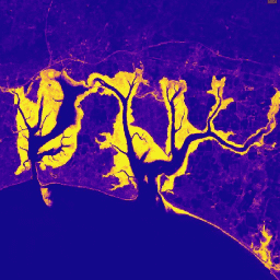
تحتوي مجموعة بيانات "موراي" العالمية للتغيّر في الأراضي الرطبة المدّية على خرائط للنطاق العالمي للأراضي الرطبة المدّية والتغيّر فيها. تم تطوير الخرائط من خلال تصنيف من ثلاث مراحل يهدف إلى (1) تقدير التوزيع العالمي للأراضي الرطبة المدّية (المعرّفة على أنّها مستنقعات مدّية أو … coastal ecosystem intertidal landsat-derived mangrove murray
Datasets tagged ecosystem in Earth Engine
[null,null,[],[],["The IUCN Global Ecosystem Typology is a six-level taxonomy for classifying ecosystems based on their unique characteristics, providing a consistent framework. The Murray Global Tidal Wetland Change Dataset offers maps of tidal wetland distribution and changes globally. This dataset utilizes a three-stage classification to estimate the global distribution of tidal wetlands, including tidal marsh and mangrove areas, derived from Landsat data. These datasets focus on ecosystem types and their change.\n"]]