-
المساحة السنوية العالمية لأشجار المانغروف (1984-2023)

توفّر مجموعة بيانات CGMD-Extent30 (ديناميكيات غابات المانغروف العالمية المستمرة - مساحة غابات المانغروف السنوية بدقة مكانية تبلغ 30 مترًا) مساحة غابات المانغروف السنوية العالمية من عام 1984 إلى 2023. يتم توزيع مجموعة البيانات كـ FeatureCollection واحدة في Earth Engine، ويمثّل كل عنصر مضلّعًا لغابات المانغروف تمّت مطابقته لسنة معيّنة. مجموعة البيانات … سنوي ساحلي كتلة حيوية للغابات عالمي مستند إلى Landsat استخدام الأراضي والغطاء الأرضي -
Global Annual Mangrove Fractional Canopy Cover (1984-2023)

توفّر مجموعة البيانات هذه معلومات عن الغطاء الأرضي السنوي الجزئي لأشجار المانغروف على مستوى العالم بدقة مكانية تبلغ 30 مترًا من عام 1984 إلى 2023، وذلك بهدف دعم التحليلات الواسعة النطاق لديناميكيات أشجار المانغروف على المدى الطويل، بما في ذلك تدهور الغطاء الأرضي واستعادته، وتقييم الكربون الأزرق، ومراقبة النظم البيئية الساحلية. تحدّد FCC نسبة كل Landsat … سنوي ساحلي كتلة حيوية للغابات عالمي مستند إلى Landsat أشجار المانغروف -
توزيع غابات المنغروف في العالم، الإصدار 1 (2000)

تم إعداد قاعدة البيانات باستخدام بيانات القمر الصناعي Landsat من عام 2000. تم تصنيف أكثر من 1,000 مشهد من Landsat تم الحصول عليها من مركز USGS Earth Resources Observation and Science Center (EROS) باستخدام تقنيات تصنيف الصور الرقمية المختلطة الخاضعة للإشراف وغير الخاضعة للإشراف. هذه القاعدة هي الأولى والأكثر … annual ciesin forest-biomass global landsat-derived mangrove -
تغيُّر الأراضي الرطبة المدّية العالمية في حوض نهر موراي، الإصدار 1.0 (1999-2019)
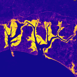
تحتوي مجموعة بيانات "موراي" للتغيّرات في الأراضي الرطبة المدّية العالمية على خرائط للنطاق العالمي للأراضي الرطبة المدّية والتغيّرات التي طرأت عليها. تم تطوير الخرائط من خلال تصنيف من ثلاث مراحل يهدف إلى (1) تقدير التوزيع العالمي للأراضي الرطبة المدية (المعرفة إما على أنّها مستنقعات مدية أو … coastal ecosystem intertidal landsat-derived mangrove murray
Datasets tagged mangrove in Earth Engine
[null,null,[],[],[]]