-
Copernicus CORINE Land Cover
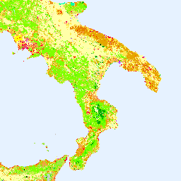
Inwentaryzacja CORINE (koordynacja informacji o środowisku) Land Cover (CLC) została zainicjowana w 1985 roku w celu ujednolicenia zbierania danych o ziemi w Europie na potrzeby tworzenia polityki środowiskowej. Projekt jest koordynowany przez Europejską Agencję Środowiska (EEA) w ramach programu UE … copernicus eea esa eu landcover landuse-landcover -
Warstwy pokrycia terenu Copernicus: CGLS-LC100 Collection 3
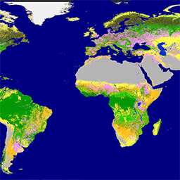
Usługa Copernicus Global Land Service (CGLS) jest przeznaczona jako komponent usługi dotyczącej powierzchni Ziemi, który ma obsługiwać wielofunkcyjny komponent usługi dostarczający szereg produktów biogeofizycznych dotyczących stanu i ewolucji powierzchni Ziemi w skali globalnej. Mapa dynamicznego pokrycia terenu w … copernicus eea esa eu landcover landuse-landcover
Datasets tagged eea in Earth Engine
[null,null,[],[],["The Copernicus program provides land cover data through two key initiatives. The CORINE Land Cover (CLC) inventory, initiated in 1985 and coordinated by the EEA, standardizes land data collection in Europe. The Copernicus Global Land Service (CGLS) offers bio-geophysical products and dynamic land cover maps at a global scale, providing insights into land surface status and evolution. Both use the European Union's resources, are associated with the European Environment Agency (EEA), European Space Agency (ESA), and focus on land cover.\n"]]