FIRMS: اطلاعات آتش برای سیستم مدیریت منابع 
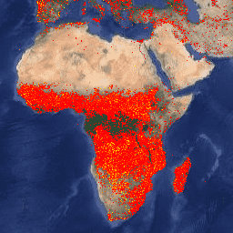
نسخه Earth Engine مجموعه داده Fire Information for Resource Management System (FIRMS) حاوی محصول تشخیص آتش LANCE به شکل شطرنجی است. مکانهای آتشسوزی فعال تقریباً بیدرنگ (NRT) توسط LANCE با استفاده از محصول استاندارد MODIS MOD14/MYD14 آتشسوزی و ناهنجاریهای حرارتی پردازش میشوند. هر… eosdis fire companys lance hotspot geophysical VJ114IMGTDL_NRT Daily Raster: VIIRS (NOAA-20) Band 375m Active Fire محصول تشخیص حریق فعال NOAA-20 (JPSS-1) مجموعه رادیومتر تصویربرداری مادون قرمز مرئی (VIIRS) بر اساس دادههای وضوح اسمی 375 متری دستگاه است. در مقایسه با سایر محصولات تشخیص حریق ماهوارهای با وضوح درشتتر (≥ 1 کیلومتر)، دادههای 375 متری بهبودیافته پاسخ بیشتری نسبت به آتشسوزیهای نسبتاً کوچک ارائه میدهند. eosdis fire companys lance hotspot geophysical VNP14IMGTDL_NRT رستر روزانه: VIIRS (S-NPP) باند 375 متری Active Fire محصول تشخیص آتش فعال Suomi NPP Visible Infrared Imaging Radiometer Suomi (VIIRS) بر اساس دادههای وضوح اسمی 375 متری دستگاه است. در مقایسه با سایر محصولات تشخیص حریق ماهوارهای با وضوح درشتتر (≥ 1 کیلومتر)، دادههای 375 متری بهبودیافته پاسخ بیشتری نسبت به آتشسوزیهای نسبتاً کوچک ارائه میدهند. eosdis fire companys lance hotspot geophysical
Datasets tagged eosdis in Earth Engine
[null,null,[],[[["\u003cp\u003eThe Fire Information for Resource Management System (FIRMS) dataset provides near real-time active fire locations based on the MODIS MOD14/MYD14 Fire and Thermal Anomalies product.\u003c/p\u003e\n"],["\u003cp\u003eThe VIIRS Active Fire detection product offers improved 375m resolution data for greater response over smaller fires, available for both NOAA-20 and Suomi NPP satellites.\u003c/p\u003e\n"],["\u003cp\u003eAll datasets utilize LANCE (Land, Atmosphere Near real-time Capability for EOS) for fire detection and are available through Earth Engine.\u003c/p\u003e\n"]]],[],null,["# Datasets tagged eosdis in Earth Engine\n\n-\n\n |-----------------------------------------------------------------------------------------------------------------------------------------------------------------------------------------------------------------------------------------------------------------------------------------------------------------------|\n | [### FIRMS: Fire Information for Resource Management System](/earth-engine/datasets/catalog/FIRMS) |\n | The Earth Engine version of the Fire Information for Resource Management System (FIRMS) dataset contains the LANCE fire detection product in rasterized form. The near real-time (NRT) active fire locations are processed by LANCE using the standard MODIS MOD14/MYD14 Fire and Thermal Anomalies product. Each ... |\n | [eosdis](/earth-engine/datasets/tags/eosdis) [fire](/earth-engine/datasets/tags/fire) [firms](/earth-engine/datasets/tags/firms) [geophysical](/earth-engine/datasets/tags/geophysical) [hotspot](/earth-engine/datasets/tags/hotspot) [lance](/earth-engine/datasets/tags/lance) |\n\n-\n\n |---------------------------------------------------------------------------------------------------------------------------------------------------------------------------------------------------------------------------------------------------------------------------------------------------------------------------------|\n | [### VJ114IMGTDL_NRT Daily Raster: VIIRS (NOAA-20) Band 375m Active Fire](/earth-engine/datasets/catalog/NASA_LANCE_NOAA20_VIIRS_C2) |\n | NOAA-20 (JPSS-1) Visible Infrared Imaging Radiometer Suite (VIIRS) Active Fire detection product is based on the instrument's 375m nominal resolution data. Compared to other coarser resolution (≥ 1km) satellite fire detection products, the improved 375 m data provide greater response over fires of relatively small ... |\n | [eosdis](/earth-engine/datasets/tags/eosdis) [fire](/earth-engine/datasets/tags/fire) [firms](/earth-engine/datasets/tags/firms) [geophysical](/earth-engine/datasets/tags/geophysical) [hotspot](/earth-engine/datasets/tags/hotspot) [lance](/earth-engine/datasets/tags/lance) |\n\n-\n\n |--------------------------------------------------------------------------------------------------------------------------------------------------------------------------------------------------------------------------------------------------------------------------------------------------------------------------|\n | [### VNP14IMGTDL_NRT Daily Raster: VIIRS (S-NPP) Band 375m Active Fire](/earth-engine/datasets/catalog/NASA_LANCE_SNPP_VIIRS_C2) |\n | Suomi NPP Visible Infrared Imaging Radiometer Suite (VIIRS) Active Fire detection product is based on the instrument's 375m nominal resolution data. Compared to other coarser resolution (≥ 1km) satellite fire detection products, the improved 375 m data provide greater response over fires of relatively small ... |\n | [eosdis](/earth-engine/datasets/tags/eosdis) [fire](/earth-engine/datasets/tags/fire) [firms](/earth-engine/datasets/tags/firms) [geophysical](/earth-engine/datasets/tags/geophysical) [hotspot](/earth-engine/datasets/tags/hotspot) [lance](/earth-engine/datasets/tags/lance) |"]]