نقشهبرداری جهانی زمین لندست ۲۰۰۵، صحنههایی از لندست ۵ 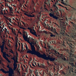
مجموعه دادههای GLS2005 مجموعهای از ۹۵۰۰ تصویر ماهوارهای با وضوح متوسط و تصحیحشده قائم است که بین سالهای ۲۰۰۴ تا ۲۰۰۷ جمعآوری شده و خشکیهای زمین را پوشش میدهد. GLS2005 عمدتاً از دادههای لندست ۵ و دادههای لندست ۷ که جای خالی دارند، به همراه دادههای EO-1 ALI و Terra ASTER که هر جای خالی را پر میکنند، استفاده میکند... تصاویر ماهوارهای ETM GLS L5 لندست رادیانس نقشهبرداری جهانی زمین لندست ۲۰۰۵، صحنههایی از لندست ۷ 
مجموعه دادههای GLS2005 مجموعهای از ۹۵۰۰ تصویر ماهوارهای با وضوح متوسط و تصحیحشده قائم است که بین سالهای ۲۰۰۴ تا ۲۰۰۷ جمعآوری شده و خشکیهای زمین را پوشش میدهد. GLS2005 عمدتاً از دادههای لندست ۵ و دادههای لندست ۷ که جای خالی دارند، به همراه دادههای EO-1 ALI و Terra ASTER که هر جای خالی را پر میکنند، استفاده میکند... تصاویر ماهوارهای ETM GLS L7 لندست رادیانس صحنههای خام رده ۱ از مجموعه ۲ لندست ۷ سازمان زمینشناسی آمریکا 
مقادیر DN رده ۱ مجموعه ۲ لندست ۷، نشاندهنده درخشندگی مقیاسبندی شده و کالیبره شده در حسگر است. صحنههای لندست با بالاترین کیفیت داده موجود در رده ۱ قرار میگیرند و برای تجزیه و تحلیل پردازش سری زمانی مناسب در نظر گرفته میشوند. رده ۱ شامل دادههای پردازش شده سطح ۱ با دقت عوارض زمینی (L1TP) است که ... c2 etm global l7 لندست le7 دادههای خام رده ۱ و بلادرنگ از مجموعه ۲ لندست ۷ سازمان زمینشناسی آمریکا (USGS) 
مجموعه لندست ۷، ردیف ۱ و مقادیر DN دادههای بلادرنگ، که نشاندهنده درخشندگی مقیاسبندی شده و کالیبره شده در حسگر هستند. صحنههای لندست با بالاترین کیفیت داده موجود در ردیف ۱ قرار میگیرند و برای تجزیه و تحلیل پردازش سری زمانی مناسب در نظر گرفته میشوند. ردیف ۱ شامل دادههای دقیق سطح ۱ (L1TP) پردازش شده ... c2 etm global l7 لندست le7 صحنههای خام رده ۲ از مجموعه ۲ لندست ۷ سازمان زمینشناسی آمریکا 
مقادیر DN رده ۲ مجموعه لندست ۷، نشاندهنده درخشندگی مقیاسبندی شده و کالیبره شده در حسگر است. صحنههایی که در طول پردازش معیارهای رده ۱ را برآورده نمیکنند، به رده ۲ اختصاص داده میشوند. این شامل صحنههای پردازش شده سیستماتیک زمین (L1GT) و سیستماتیک (L1GS) و همچنین هر صحنه L1TP که ... را ندارند، میشود. c2 etm global l7 لندست le7 ماهواره لندست ۷ سازمان زمینشناسی آمریکا (USGS) سطح ۲، مجموعه ۲، ردیف ۱ 
این مجموعه داده شامل بازتاب سطحی تصحیحشده از نظر جوی و دمای سطح زمین است که از دادههای تولید شده توسط سنجنده ETM+ ماهواره لندست ۷ گرفته شده است. این تصاویر شامل ۴ باند مرئی و مادون قرمز نزدیک (VNIR) و ۲ باند مادون قرمز موج کوتاه (SWIR) هستند که برای بازتاب سطحی تصحیحشده قائم پردازش شدهاند و یک باند حرارتی ... CFmask cloud، ETM، Fmask، لندست جهانی ماهواره لندست ۷ سازمان زمینشناسی آمریکا (USGS) سطح ۲، مجموعه ۲، ردیف ۲ 
این مجموعه داده شامل بازتاب سطحی تصحیحشده از نظر جوی و دمای سطح زمین است که از دادههای تولید شده توسط سنجنده ETM+ ماهواره لندست ۷ گرفته شده است. این تصاویر شامل ۴ باند مرئی و مادون قرمز نزدیک (VNIR) و ۲ باند مادون قرمز موج کوتاه (SWIR) هستند که برای بازتاب سطحی تصحیحشده قائم پردازش شدهاند و یک باند حرارتی ... CFmask cloud، ETM، Fmask، لندست جهانی
Datasets tagged etm in Earth Engine
[null,null,[],[],["The datasets are from the Landsat program, specifically Landsat 5 and 7. The GLS2005 dataset contains 9500 orthorectified satellite images from 2004-2007, using Landsat 5 and 7, with some other satellites to fill gaps. Landsat 7 Collection 2 datasets include Tier 1, Tier 2 and real-time raw scenes. It also contains Level 2 datasets which have surface reflectance and land surface temperature derived from the Landsat 7 sensor.\n"]]