অস্ট্রেলিয়ান ৫এম ডিইএম 
LiDAR মডেল থেকে প্রাপ্ত অস্ট্রেলিয়ার ডিজিটাল এলিভেশন মডেল (DEM) ৫ মিটার গ্রিড একটি জাতীয় ৫ মিটার (খালি মাটি) DEM প্রতিনিধিত্ব করে যা ২০০১ থেকে ২০১৫ সালের মধ্যে প্রায় ২৩৬টি পৃথক LiDAR জরিপ থেকে প্রাপ্ত হয়েছে যা ২৪৫,০০০ বর্গকিলোমিটারেরও বেশি এলাকা জুড়ে বিস্তৃত। … অস্ট্রেলিয়া ডেম এলিভেশন এলিভেশন-ভূগোল জিএ জিওফিজিক্যাল DEM-H: অস্ট্রেলিয়ান SRTM হাইড্রোলজিক্যালি এনফোর্সড ডিজিটাল এলিভেশন মডেল 
হাইড্রোলজিক্যালি এনফোর্সড ডিজিটাল এলিভেশন মডেল (DEM-H) ২০০০ সালের ফেব্রুয়ারিতে NASA কর্তৃক অর্জিত SRTM তথ্য থেকে উদ্ভূত হয়েছিল। মডেলটি হাইড্রোলজিক্যালি কন্ডিশনড এবং ড্রেনেজ প্রয়োগ করা হয়েছে। DEM-H SRTM উচ্চতা এবং ম্যাপ করা স্ট্রিম লাইনের উপর ভিত্তি করে প্রবাহ পথ ক্যাপচার করে এবং ... এর সীমানা নির্ধারণ সমর্থন করে। অস্ট্রেলিয়া ডেম এলিভেশন এলিভেশন-ভূগোল জিএ জিওফিজিক্যাল DEM-S: অস্ট্রেলিয়ান স্মুথেড ডিজিটাল এলিভেশন মডেল 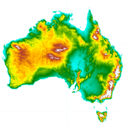
স্মুথেড ডিজিটাল এলিভেশন মডেল (DEM-S) ২০০০ সালের ফেব্রুয়ারিতে NASA কর্তৃক অর্জিত SRTM তথ্য থেকে উদ্ভূত হয়েছিল। DEM-S ভূপৃষ্ঠের ভূসংস্থান (উদ্ভিদ বৈশিষ্ট্য বাদে) উপস্থাপন করে এবং শব্দ কমাতে এবং পৃষ্ঠের আকৃতির উপস্থাপনা উন্নত করার জন্য এটিকে মসৃণ করা হয়েছে। একটি অভিযোজিত প্রক্রিয়া আরও প্রয়োগ করা হয়েছে ... অস্ট্রেলিয়া ডেম এলিভেশন এলিভেশন-ভূগোল জিএ জিওফিজিক্যাল ন্যাশনাল ইন্টারটাইডাল ডিজিটাল এলিভেশন মডেল ২৫ মিটারের পূর্বরূপ দেখুন ১.০.০ 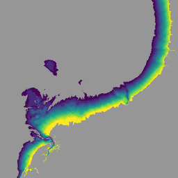
ন্যাশনাল ইন্টারটাইডাল ডিজিটাল এলিভেশন মডেল (NIDEM; বিশপ-টেলর এবং অন্যান্যরা 2018, 2019) হল অস্ট্রেলিয়ার উন্মুক্ত আন্তঃজলোয়ার অঞ্চলের জন্য একটি মহাদেশীয়-স্কেল উচ্চতা ডেটাসেট। NIDEM অস্ট্রেলিয়ার আন্তঃজলোয়ার বালুকাময় সৈকত এবং তীর, জোয়ারের সমতল এবং পাথুরে তীর এবং প্রাচীরের 25 মিটার উচ্চতায় প্রথম ত্রিমাত্রিক উপস্থাপনা প্রদান করে ... অস্ট্রেলিয়া ডেম এলিভেশন-ভূগোল জিএ
Datasets tagged ga in Earth Engine
[null,null,[],[],["The datasets provide various models and data for Australia. These include Digital Elevation Models (DEMs) at 5m resolution from LiDAR surveys and hydrologically enforced/smoothed DEMs derived from SRTM data. The National Intertidal DEM represents Australia's intertidal zone at 25m. Also featured are Landsat-derived products like annual land cover classifications, water observation statistics, and geometric median/median absolute deviation datasets. These Landsat products utilize Landsat 5, 7, 8, and 9 data to provide insights into annual conditions and changes.\n"]]