Page Summary
-
The Australian 5M DEM is a 5-meter bare earth digital elevation model derived from LiDAR surveys conducted between 2001 and 2015.
-
The DEM-H is a hydrologically enforced digital elevation model of Australia derived from SRTM data, designed to capture flow paths.
-
The DEM-S is a smoothed digital elevation model of Australia, also derived from SRTM data, representing ground surface topography with reduced noise.
-
NIDEM is a continental-scale elevation dataset providing a three-dimensional representation of Australia's exposed intertidal zone at 25m resolution.
-
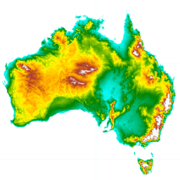
Australian 5M DEM
The Digital Elevation Model (DEM) 5 meter Grid of Australia derived from LiDAR model represents a National 5 meter (bare earth) DEM which has been derived from some 236 individual LiDAR surveys between 2001 and 2015 covering an area in excess of 245,000 square kilometers. … australia dem elevation elevation-topography ga geophysical -
DEM-H: Australian SRTM Hydrologically Enforced Digital Elevation Model
The Hydrologically Enforced Digital Elevation Model (DEM-H) was derived from the SRTM data acquired by NASA in February 2000. The model has been hydrologically conditioned and drainage enforced. The DEM-H captures flow paths based on SRTM elevations and mapped stream lines, and supports delineation of … australia dem elevation elevation-topography ga geophysical -
DEM-S: Australian Smoothed Digital Elevation Model

The Smoothed Digital Elevation Model (DEM-S) was derived from the SRTM data acquired by NASA in February 2000. DEM-S represents ground surface topography (excluding vegetation features) and has been smoothed to reduce noise and improve the representation of surface shape. An adaptive process applied more … australia dem elevation elevation-topography ga geophysical -
Preview National Intertidal Digital Elevation Model 25m 1.0.0
The National Intertidal Digital Elevation Model (NIDEM; Bishop-Taylor et al. 2018, 2019) is a continental-scale elevation dataset for Australia's exposed intertidal zone. NIDEM provides the first three-dimensional representation of Australia's intertidal sandy beaches and shores, tidal flats and rocky shores and reefs at 25 m … australia dem elevation-topography ga