-
GOES-18 FDCC シリーズ ABI レベル 2 火災/ホットスポット特性評価 CONUS

Fire(HSC)プロダクトには 4 つの画像が含まれています。1 つは火災マスクの形式で、残りの 3 つは火災の温度、火災の面積、火災の放射エネルギーを特定するピクセル値が含まれています。ABI L2+ FHS メタデータ マスクは、… abi fdc fire goes goes-18 goes-t -
GOES-18 FDCF シリーズ ABI レベル 2 火災/ホットスポット特性評価フルディスク

Fire(HSC)プロダクトには 4 つの画像が含まれています。1 つは火災マスクの形式で、残りの 3 つは火災の温度、火災の面積、火災の放射エネルギーを特定するピクセル値が含まれています。ABI L2+ FHS メタデータ マスクは、… abi fdc fire goes goes-18 goes-t -
GOES-18 MCMIPC シリーズ ABI レベル 2 雲と水分の画像(米国本土)

雲と水分の画像プロダクトはすべて 2 km の解像度です。バンド 1 ~ 6 は反射します。無次元の「反射率係数」は太陽天頂角で正規化されます。これらのバンドは、雲、植生、雪氷、エアロゾルの特性評価をサポートしています。バンド 7 ~ 16 は発光性です。輝度温度は … abi atmosphere goes goes-18 goes-t goes-west -
GOES-18 MCMIPF シリーズ ABI レベル 2 雲と水分の画像フルディスク
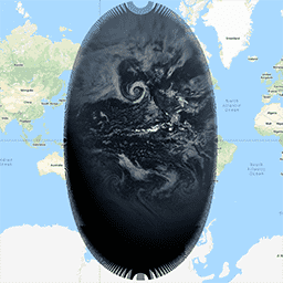
雲と水分の画像プロダクトはすべて 2 km の解像度です。バンド 1 ~ 6 は反射します。無次元の「反射率係数」は太陽天頂角で正規化されます。これらのバンドは、雲、植生、雪氷、エアロゾルの特性評価をサポートしています。バンド 7 ~ 16 は発光性です。輝度温度は … abi atmosphere goes goes-18 goes-t goes-west -
GOES-18 MCMIPM シリーズ ABI レベル 2 雲と水分の画像(メソスケール)

雲と水分の画像プロダクトはすべて 2 km の解像度です。バンド 1 ~ 6 は反射します。無次元の「反射率係数」は太陽天頂角で正規化されます。これらのバンドは、雲、植生、雪氷、エアロゾルの特性評価をサポートしています。バンド 7 ~ 16 は発光性です。輝度温度は … abi atmosphere goes goes-18 goes-t goes-west
Datasets tagged goes-t in Earth Engine
[null,null,[],[],["GOES-18 provides two main product types: Fire/Hot Spot Characterization (FHS) and Cloud and Moisture Imagery. FHS data includes a fire mask and pixel values for fire temperature, area, and radiative power. Cloud and Moisture Imagery, at 2km resolution, uses reflective (bands 1-6) and emissive bands (7-16) to characterize clouds, vegetation, snow/ice, and aerosols. Both products offer CONUS and full disk views.\n"]]