-
MERIT Hydro: 글로벌 수로학 데이터 세트
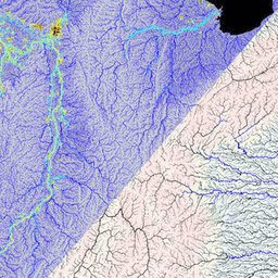
MERIT Hydro는 MERIT DEM 고도 데이터 및 수역 데이터 세트 (G1WBM, GSWO, OpenStreetMap)의 버전 1.0.3에서 파생된 3초 (적도 기준 약 90m) 해상도의 새로운 글로벌 흐름 방향 지도입니다. MERIT Hydro에 새 … dem elevation flow-direction hand hydrography hydrosheds -
MERIT Hydro: 보충 시각화 레이어
MERIT Hydro를 위한 보충 시각화 레이어 dem elevation flow-direction hand hydrography hydrosheds
Datasets tagged hand in Earth Engine
[null,null,[],[[["\u003cp\u003eMERIT Hydro offers a novel global flow direction map at ~90m resolution, created using MERIT DEM, G1WBM, GSWO, and OpenStreetMap data.\u003c/p\u003e\n"],["\u003cp\u003eSupplementary visualization layers are available to aid in visualizing and understanding the MERIT Hydro dataset.\u003c/p\u003e\n"]]],[],null,["# Datasets tagged hand in Earth Engine\n\n-\n\n |-------------------------------------------------------------------------------------------------------------------------------------------------------------------------------------------------------------------------------------------------------------------------------------------------------------|\n | [### MERIT Hydro: Global Hydrography Datasets](/earth-engine/datasets/catalog/MERIT_Hydro_v1_0_1) |\n | MERIT Hydro is a new global flow direction map at 3 arc-second resolution (\\~90 m at the equator) derived from the version 1.0.3 of the MERIT DEM elevation data and water body datasets (G1WBM, GSWO and OpenStreetMap). MERIT Hydro contains the output of a new ... |\n | [dem](/earth-engine/datasets/tags/dem) [elevation](/earth-engine/datasets/tags/elevation) [flow-direction](/earth-engine/datasets/tags/flow-direction) [hand](/earth-engine/datasets/tags/hand) [hydrography](/earth-engine/datasets/tags/hydrography) [hydrosheds](/earth-engine/datasets/tags/hydrosheds) |\n\n-\n\n |-------------------------------------------------------------------------------------------------------------------------------------------------------------------------------------------------------------------------------------------------------------------------------------------------------------|\n | [### MERIT Hydro: Supplementary Visualization Layers](/earth-engine/datasets/catalog/MERIT_Hydro_reduced_v1_0_1) |\n | Supplementary visualization layers for MERIT Hydro |\n | [dem](/earth-engine/datasets/tags/dem) [elevation](/earth-engine/datasets/tags/elevation) [flow-direction](/earth-engine/datasets/tags/flow-direction) [hand](/earth-engine/datasets/tags/hand) [hydrography](/earth-engine/datasets/tags/hydrography) [hydrosheds](/earth-engine/datasets/tags/hydrosheds) |"]]