-
GHSL: 2018년 전 세계 건물 높이 (P2023A)
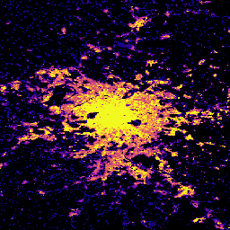
이 공간 래스터 데이터 세트는 2018년을 기준으로 100m 해상도의 전 세계 건물 높이 분포를 보여줍니다. 건물 높이를 예측하는 데 사용되는 입력 데이터는 ALOS Global Digital Surface Model (30m), NASA Shuttle Radar Topographic Mission … alos building built built-environment builtup copernicus -
GHSL: 전 세계 정착지 특성 (10m) 2018 (P2023A)
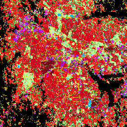
이 공간 래스터 데이터 세트는 10m 해상도로 인적 거주지를 나타내며, 건축 환경의 기능 및 높이 관련 구성요소 측면에서 내부 특성을 설명합니다. GHSL 데이터 제품에 대한 자세한 내용은 GHSL 데이터 패키지 2023 보고서에서 확인할 수 있습니다. building built builtup copernicus ghsl height -
Open Buildings Temporal V1

Open Buildings 2.5D Temporal Dataset에는 2016년부터 2023년까지 연간 주기로 4m의 효과적인 공간 해상도 (래스터는 0.5m 해상도로 제공됨)에서 건물 존재, 분수 건물 수, 건물 높이에 관한 데이터가 포함되어 있습니다. 이 이미지는 …의 오픈소스 저해상도 이미지에서 생성됩니다. africa annual asia built-up height open-buildings
Datasets tagged height in Earth Engine
[null,null,[],[],["The Open Buildings Temporal Dataset offers annual data from 2016-2023 on building presence, counts, and heights at a 4m resolution, derived from low-resolution imagery. The GHSL dataset provides 10m resolution data on human settlements, detailing built environment characteristics and heights. Another GHSL dataset maps global building heights at 100m resolution for 2018, using data from sources like the ALOS Global Digital Surface Model.\n"]]