-
Klasifikasi Perubahan Antartidal Global Murray

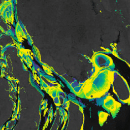
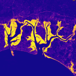
Set Data Perubahan Antartidal Global Murray berisi peta global ekosistem dataran pasang surut yang dihasilkan melalui klasifikasi terawasi dari 707.528 gambar Arsip Landsat. Setiap piksel diklasifikasikan ke dalam dataran pasang surut, air permanen, atau lainnya dengan mengacu pada kumpulan data pelatihan yang didistribusikan secara global. … coastal google intertidal landsat-derived murray surface-ground-water -
Masker Data Perubahan Antartidal Global Murray

Set Data Perubahan Antartidal Global Murray berisi peta global ekosistem dataran pasang surut yang dihasilkan melalui klasifikasi terawasi dari 707.528 gambar Arsip Landsat. Setiap piksel diklasifikasikan ke dalam dataran pasang surut, air permanen, atau lainnya dengan mengacu pada kumpulan data pelatihan yang didistribusikan secara global. … coastal google intertidal landsat-derived murray surface-ground-water -
Jumlah Piksel QA Perubahan Antartidal Global Murray
Set Data Perubahan Antartidal Global Murray berisi peta global ekosistem dataran pasang surut yang dihasilkan melalui klasifikasi terawasi dari 707.528 gambar Arsip Landsat. Setiap piksel diklasifikasikan ke dalam dataran pasang surut, air permanen, atau lainnya dengan mengacu pada kumpulan data pelatihan yang didistribusikan secara global. … coastal google intertidal landsat-derived murray surface-ground-water -
Perubahan Lahan Basah Pasang Surut Global Murray v1.0 (1999-2019)
Set Data Perubahan Lahan Basah Pasang Surut Global Murray berisi peta luas global lahan basah pasang surut dan perubahannya. Peta ini dikembangkan dari klasifikasi tiga tahap yang berupaya (i) memperkirakan distribusi global lahan basah pasang surut (didefinisikan sebagai rawa pasang surut, pasang surut … coastal ecosystem intertidal landsat-derived mangrove murray
Datasets tagged intertidal in Earth Engine
[null,null,[],[],["The content describes the Murray Global datasets, which map tidal wetland and intertidal flat ecosystems. The Tidal Wetland Change Dataset estimates the global distribution of tidal marshes and other tidal ecosystems. The Intertidal Change datasets classify pixels from 707,528 Landsat images into tidal flat, permanent water, or other categories. These datasets use a globally distributed training data to classify and map the global extent of intertidal areas and track changes.\n"]]