-
การจำแนกการเปลี่ยนแปลงของพื้นที่ชายฝั่งระหว่างน้ำขึ้นน้ำลงทั่วโลกของเมอร์เรย์

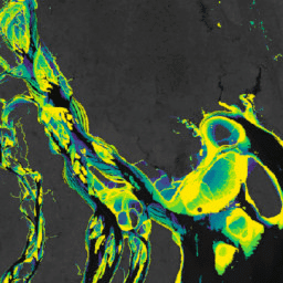
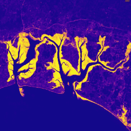
ชุดข้อมูลการเปลี่ยนแปลงช่วงน้ำขึ้นน้ำลงทั่วโลกของ Murray มีแผนที่ทั่วโลกของระบบนิเวศหาดเลนที่เกิดจากการจัดประเภทภายใต้การควบคุมของภาพจากคลังข้อมูล Landsat จำนวน 707,528 ภาพ พิกเซลแต่ละพิกเซลได้รับการจัดประเภทเป็นหาดเลน แหล่งน้ำถาวร หรืออื่นๆ โดยอ้างอิงชุดข้อมูลฝึกฝนที่กระจายอยู่ทั่วโลก The … ชายฝั่ง google intertidal landsat-derived murray surface-ground-water -
มาสก์ข้อมูลการเปลี่ยนแปลงบริเวณน้ำขึ้นน้ำลงทั่วโลกของ Murray

ชุดข้อมูลการเปลี่ยนแปลงช่วงน้ำขึ้นน้ำลงทั่วโลกของ Murray มีแผนที่ทั่วโลกของระบบนิเวศหาดเลนที่เกิดจากการจัดประเภทภายใต้การควบคุมของภาพจากคลังข้อมูล Landsat จำนวน 707,528 ภาพ พิกเซลแต่ละพิกเซลได้รับการจัดประเภทเป็นหาดเลน แหล่งน้ำถาวร หรืออื่นๆ โดยอ้างอิงชุดข้อมูลฝึกฝนที่กระจายอยู่ทั่วโลก The … ชายฝั่ง google intertidal landsat-derived murray surface-ground-water -
Murray Global Intertidal Change QA Pixel Count
ชุดข้อมูลการเปลี่ยนแปลงช่วงน้ำขึ้นน้ำลงทั่วโลกของ Murray มีแผนที่ทั่วโลกของระบบนิเวศหาดเลนที่เกิดจากการจัดประเภทภายใต้การควบคุมของภาพจากคลังข้อมูล Landsat จำนวน 707,528 ภาพ พิกเซลแต่ละพิกเซลได้รับการจัดประเภทเป็นหาดเลน แหล่งน้ำถาวร หรืออื่นๆ โดยอ้างอิงชุดข้อมูลฝึกฝนที่กระจายอยู่ทั่วโลก The … ชายฝั่ง google intertidal landsat-derived murray surface-ground-water -
การเปลี่ยนแปลงพื้นที่ชุ่มน้ำชายฝั่งทั่วโลกของเมอร์เรย์ v1.0 (1999-2019)
ชุดข้อมูลการเปลี่ยนแปลงพื้นที่ชุ่มน้ำชายฝั่งทั่วโลกของ Murray มีแผนที่ขอบเขตทั่วโลกของพื้นที่ชุ่มน้ำชายฝั่งและการเปลี่ยนแปลงของพื้นที่ดังกล่าว แผนที่นี้ได้รับการพัฒนาจากการจัดประเภท 3 ขั้นตอนที่มุ่ง (1) ประมาณการการกระจายตัวของพื้นที่ชุ่มน้ำขึ้นน้ำลงทั่วโลก (กำหนดเป็นทั้งที่ลุ่มน้ำขึ้นน้ำลง ที่ลุ่ม … coastal ecosystem intertidal landsat-derived mangrove murray
Datasets tagged intertidal in Earth Engine
[null,null,[],[],["The content describes the Murray Global datasets, which map tidal wetland and intertidal flat ecosystems. The Tidal Wetland Change Dataset estimates the global distribution of tidal marshes and other tidal ecosystems. The Intertidal Change datasets classify pixels from 707,528 Landsat images into tidal flat, permanent water, or other categories. These datasets use a globally distributed training data to classify and map the global extent of intertidal areas and track changes.\n"]]