-
GlobFire Daily Fire Event Detection Based on MCD64A1
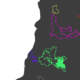
Granice pożarów na podstawie zbioru danych MODIS MCD64A1. Dane zostały obliczone na podstawie algorytmu, który opiera się na kodowaniu w strukturze wykresu relacji czasowo-przestrzennych między obszarami objętymi pożarem. Każdy pożar ma unikalny numer identyfikujący zdarzenie. area burnt disaster fire globfire mcd64a1 -
GlobFire Final Fire Event Detection Based on MCD64A1

Granice pożarów na podstawie zbioru danych MODIS MCD64A1. Dane zostały obliczone na podstawie algorytmu, który opiera się na kodowaniu w strukturze wykresu relacji czasowo-przestrzennych między obszarami objętymi pożarem. Każdy pożar ma unikalny numer identyfikujący zdarzenie. area burnt disaster fire globfire mcd64a1 -
MCD64A1.061 MODIS Burned Area Monthly Global 500m

Połączony produkt danych MCD64A1 Version 6.1 Burned Area z satelitów Terra i Aqua to miesięczny, globalny produkt w siatce o rozdzielczości 500 m, który zawiera informacje o obszarach spalonych i jakości dla każdego piksela. Metoda mapowania obszarów spalonych MCD64A1 wykorzystuje obrazy współczynnika odbicia światła MODIS o rozdzielczości 500 m w połączeniu z obserwacjami aktywnych pożarów MODIS o rozdzielczości 1 km. Algorytm… burn change-detection fire geophysical global mcd64a1
Datasets tagged mcd64a1 in Earth Engine
[null,null,[],[],["The content describes three datasets related to fire and burned areas, all utilizing the MODIS MCD64A1 dataset. Two datasets, \"GlobFire Daily\" and \"GlobFire Final,\" provide fire boundaries, computed by an algorithm using the space-time relationships between burned patches, each with a unique identifier. The third dataset, \"MCD64A1.061,\" is a monthly global product with 500m resolution, detailing burned areas and quality using surface reflectance imagery and active fire observations.\n"]]