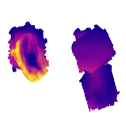
-
MethaneAIR L3 Concentration v1
Ten zbiór danych zawiera dane geoprzestrzenne dotyczące całkowitej kolumny suchego powietrza w powietrzu atmosferycznym, „XCH4”, obserwowanego przez spektrometr obrazowania MethaneAIR. XCH4 jest zdefiniowany jako łączna ilość kolumny (liczba cząsteczek) metanu („CH4”) podzielona przez łączną ilość … atmosfera klimat edf emisje ghg metan -
MethaneAIR L4 Area Sources v1
Model emisji na obszarze jest wciąż w fazie rozwoju i nie jest reprezentatywny dla produktu końcowego. Ten zbiór danych zawiera przestrzennie zróżnicowane natężenia emisji metanu (kg/godz.) na podstawie pomiarów z lotów MethaneAIR w regionach wydobycia ropy i gazu w Stanach Zjednoczonych. Łączna emisja w ankiecie atmosfera klimat edf emisje ghg metan -
MethaneAIR L4 Point Sources v1
Ten zbiór danych zawiera dane o wysokiej emisji metanu z punktowych źródeł (kg/godz.) w 13 obszarach wydobycia ropy i gazu lub węgla od Kolorado, Nowego Meksyku i Teksasu na zachodzie po Pensylwanię, Ohio i Wirginię Zachodnią na wschodzie oraz 3 obszary miejskie (Nowy Jork, … atmosfera klimat edf emisje ghg metan -
OGIM: baza danych o mapowaniu infrastruktury ropy i gazu w wersji 2.5.1
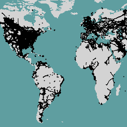
Ten zbiór danych zawiera lokalizacje infrastruktury związanej z ropą i gazem na całym świecie. Baza danych OGIM to projekt opracowany przez Environmental Defense Fund (EDF) i MethaneSAT LLC, w 100% należący do EDF. Głównym celem opracowania … edf emissions ghg infrastructure-boundaries methane methaneair
Datasets tagged methaneair in Earth Engine
[null,null,[],[[["\u003cp\u003eThe MethaneAIR L3 Concentration dataset provides geospatial data on the total column dry air mole fraction of methane in the atmosphere as observed by the MethaneAIR imaging spectrometer.\u003c/p\u003e\n"],["\u003cp\u003eThe MethaneAIR L4 Area Sources dataset provides spatially disaggregated methane emission fluxes, focusing on oil and gas producing regions, but is still under development.\u003c/p\u003e\n"],["\u003cp\u003eThe MethaneAIR L4 Point Sources dataset identifies high-emitting methane point sources across various oil, gas, and coal extraction areas, as well as urban areas.\u003c/p\u003e\n"],["\u003cp\u003eThe OGIM dataset maps the locations of oil and gas infrastructure globally, aiding in understanding and mitigating methane emissions.\u003c/p\u003e\n"]]],[],null,["# Datasets tagged methaneair in Earth Engine\n\n-\n\n |------------------------------------------------------------------------------------------------------------------------------------------------------------------------------------------------------------------------------------------------------------------------------------------------|\n | [### MethaneAIR L3 Concentration v1](/earth-engine/datasets/catalog/EDF_MethaneSAT_MethaneAIR_L3concentration) |\n | This dataset provides geospatial data for the total column dry air mole fraction of methane in the atmosphere, \"XCH4\", as observed by the MethaneAIR imaging spectrometer. XCH4 is defined as the total column amount (number of molecules) of methane (\"CH4\") divided by the total amount ... |\n | [atmosphere](/earth-engine/datasets/tags/atmosphere) [climate](/earth-engine/datasets/tags/climate) [edf](/earth-engine/datasets/tags/edf) [emissions](/earth-engine/datasets/tags/emissions) [ghg](/earth-engine/datasets/tags/ghg) [methane](/earth-engine/datasets/tags/methane) |\n\n-\n\n |--------------------------------------------------------------------------------------------------------------------------------------------------------------------------------------------------------------------------------------------------------------------------------------------------------------------------------|\n | [### MethaneAIR L4 Area Sources v1](/earth-engine/datasets/catalog/EDF_MethaneSAT_MethaneAIR_L4area) |\n | The area emissions model is still in development and not representative of a final product. This dataset provides spatially disaggregated methane emission fluxes (kg/hr) using measurements from MethaneAIR flights focused on oil and gas producing regions throughout the United States. Total emissions for the survey ... |\n | [atmosphere](/earth-engine/datasets/tags/atmosphere) [climate](/earth-engine/datasets/tags/climate) [edf](/earth-engine/datasets/tags/edf) [emissions](/earth-engine/datasets/tags/emissions) [ghg](/earth-engine/datasets/tags/ghg) [methane](/earth-engine/datasets/tags/methane) |\n\n-\n\n |-------------------------------------------------------------------------------------------------------------------------------------------------------------------------------------------------------------------------------------------------------------------------------------|\n | [### MethaneAIR L4 Point Sources v1](/earth-engine/datasets/catalog/EDF_MethaneSAT_MethaneAIR_L4point) |\n | This dataset provides data for high-emitting methane point source detections (kg/hr) over 13 oil and gas or coal extraction areas from Colorado, New Mexico, and Texas in the west to Pennsylvania, Ohio, and West Virginia in the east, plus three urban areas (New York City, ... |\n | [atmosphere](/earth-engine/datasets/tags/atmosphere) [climate](/earth-engine/datasets/tags/climate) [edf](/earth-engine/datasets/tags/edf) [emissions](/earth-engine/datasets/tags/emissions) [ghg](/earth-engine/datasets/tags/ghg) [methane](/earth-engine/datasets/tags/methane) |\n\n-\n\n |-------------------------------------------------------------------------------------------------------------------------------------------------------------------------------------------------------------------------------------------------------------------------------------------------------------------------|\n | [### OGIM: Oil and Gas Infrastructure Mapping Database v2.5.1](/earth-engine/datasets/catalog/EDF_OGIM_current) |\n | This dataset provides the locations of oil and gas (O\\&G) related infrastructure globally. The Oil and Gas Infrastructure Mapping (OGIM) database is a project developed by the Environmental Defense Fund (EDF) and MethaneSAT LLC, a wholly-owned subsidiary of EDF. The primary objective of developing a ... |\n | [edf](/earth-engine/datasets/tags/edf) [emissions](/earth-engine/datasets/tags/emissions) [ghg](/earth-engine/datasets/tags/ghg) [infrastructure-boundaries](/earth-engine/datasets/tags/infrastructure-boundaries) [methane](/earth-engine/datasets/tags/methane) [methaneair](/earth-engine/datasets/tags/methaneair) |"]]