নিয়ন ক্যানোপি হাইট মডেল (CHM) 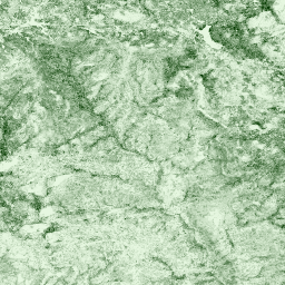
খালি মাটির উপরে ক্যানোপির উপরের উচ্চতা (ক্যানোপি উচ্চতা মডেল; CHM)। CHM নিওন LiDAR বিন্দু মেঘ থেকে উদ্ভূত এবং LiDAR জরিপের সমগ্র স্থানিক ডোমেন জুড়ে ক্যানোপি উচ্চতা অনুমানের একটি অবিচ্ছিন্ন পৃষ্ঠ তৈরি করে তৈরি করা হয়। … বায়ুবাহিত ছাউনি বন বন-জৈববস্তু লিডার নিয়ন নিওন ডিজিটাল এলিভেশন মডেল (ডিইএম) 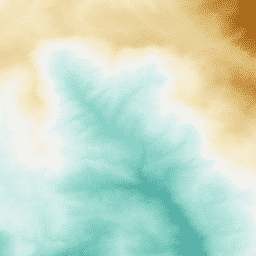
NEON LiDAR তথ্য থেকে প্রাপ্ত পৃষ্ঠতলের ডিজিটাল মডেল (DSM) এবং ভূখণ্ড (DTM)। DSM: পৃষ্ঠতলের বৈশিষ্ট্য (উদ্ভিদ এবং মানবসৃষ্ট কাঠামো সহ ভূ-তাত্ত্বিক তথ্য)। DTM: খালি মাটির উচ্চতা (উদ্ভিদ এবং মানবসৃষ্ট কাঠামো অপসারণ সহ ভূ-তাত্ত্বিক তথ্য)। চিত্রগুলি সমুদ্রের গড় উচ্চতা থেকে মিটারে দেওয়া হয়েছে ... বায়ুবাহিত ডেম উচ্চতা-ভূগোল বন লিডার নিয়ন নিয়ন আরজিবি ক্যামেরার চিত্রাবলী 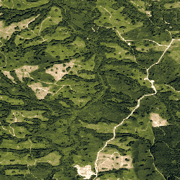
উচ্চ রেজোলিউশনের লাল-সবুজ-নীল (RGB) অর্থোরেক্টিফাইড ক্যামেরার ছবিগুলি মোজাইক করা হয় এবং নিকটতম-প্রতিবেশী রিস্যাম্পলিং ব্যবহার করে একটি স্থির, অভিন্ন স্থানিক গ্রিডে আউটপুট করা হয়; স্থানিক রেজোলিউশন 0.1 মিটার। ডিজিটাল ক্যামেরাটি NEON এয়ারবর্ন অবজারভেশন প্ল্যাটফর্ম (AOP) এর একটি স্যুটের অংশ যার মধ্যে একটি … বায়ুবাহিত বন হাইরেস নিয়ন নিয়ন-প্রোড-আর্থইঞ্জিন অর্থোফটো নিওন পৃষ্ঠ দ্বিমুখী প্রতিফলন 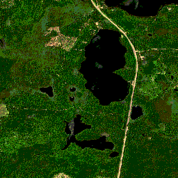
নিওন এওপি সারফেস দ্বিমুখী প্রতিফলন হল একটি হাইপারস্পেকট্রাল ভিএসডব্লিউআইআর (শর্টওয়েভ ইনফ্রারেডের কাছে দৃশ্যমান) ডেটা পণ্য, যার তরঙ্গদৈর্ঘ্য ~380 এনএম থেকে 2510 এনএম পর্যন্ত বিস্তৃত 426 ব্যান্ড রয়েছে। প্রতিফলনকে 10000 এর গুণক দ্বারা স্কেল করা হয়। 1340-1445 এনএম এবং 1790-1955 এনএম এর মধ্যে তরঙ্গদৈর্ঘ্য সেট করা হয়েছে ... বায়ুবাহিত বন হাইপারস্পেকট্রাল নিয়ন নিয়ন-প্রোড-আর্থইঞ্জিন প্রকাশক-ডেটাসেট নিওন পৃষ্ঠের দিকনির্দেশনামূলক প্রতিফলন 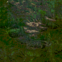
নিওন এওপি সারফেস ডিরেকশনাল রিফ্লেক্ট্যান্স হল একটি হাইপারস্পেকট্রাল ভিএসডব্লিউআইআর (শর্টওয়েভ ইনফ্রারেডের কাছে দৃশ্যমান) ডেটা পণ্য, যার তরঙ্গদৈর্ঘ্য ~380 এনএম থেকে 2510 এনএম পর্যন্ত বিস্তৃত 426 ব্যান্ড রয়েছে। প্রতিফলনকে 10000 এর গুণক দ্বারা স্কেল করা হয়। 1340-1445 এনএম এবং 1790-1955 এনএম এর মধ্যে তরঙ্গদৈর্ঘ্য সেট করা হয়েছে ... বায়ুবাহিত বন হাইপারস্পেকট্রাল নিয়ন নিয়ন-প্রোড-আর্থইঞ্জিন প্রকাশক-ডেটাসেট
Datasets tagged neon-prod-earthengine in Earth Engine
[null,null,[],[],[]]