উত্তর আমেরিকার ভূমি আচ্ছাদন ৩০ মিটার, ২০২০ 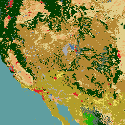
২০২০ সালের উত্তর আমেরিকার ভূমি কভার ৩০-মিটার ডেটাসেটটি উত্তর আমেরিকার ভূমি পরিবর্তন পর্যবেক্ষণ ব্যবস্থা (NALCMS) এর অংশ হিসাবে তৈরি করা হয়েছিল, যা প্রাকৃতিক সম্পদ কানাডা, মার্কিন যুক্তরাষ্ট্রের ভূতাত্ত্বিক জরিপ এবং জাতীয় পরিসংখ্যান ও ভূগোল ইনস্টিটিউট সহ তিনটি মেক্সিকান সংস্থার মধ্যে একটি ত্রিপক্ষীয় প্রচেষ্টা ... ল্যান্ডকভার ল্যান্ডস্যাট ল্যান্ডইউজ-ল্যান্ডকভার এনএলসিডি প্রতিফলন এনএলসিডি ২০১৯: ইউএসজিএস জাতীয় ভূমি কভার ডাটাবেস, ২০১৯ প্রকাশ 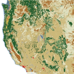
এনএলসিডি (জাতীয় ভূমি আচ্ছাদন ডেটাবেস) হল একটি ৩০-মিটার ল্যান্ডস্যাট-ভিত্তিক ভূমি আচ্ছাদন ডেটাবেস যা ৮টি যুগ (২০০১, ২০০৪, ২০০৬, ২০০৮, ২০১১, ২০১৩, ২০১৬ এবং ২০১৯) জুড়ে বিস্তৃত। ২০২১ সালের জন্য একটি নবম যুগও এখানে পাওয়া যাচ্ছে। ছবিগুলি নগর... এর জন্য অভেদ্যতা ডেটা স্তরের উপর নির্ভর করে। বিএলএম ল্যান্ডকভার ল্যান্ডইউজ-ল্যান্ডকভার এমআরএলসি এনএলসিডি ইউএসজি NLCD 2021: USGS জাতীয় ভূমি কভার ডাটাবেস, 2021 প্রকাশ 
মার্কিন ভূতাত্ত্বিক জরিপ (USGS), বেশ কয়েকটি ফেডারেল সংস্থার সাথে অংশীদারিত্বে, এখন সাতটি জাতীয় ভূমি কভার ডাটাবেস (NLCD) পণ্য তৈরি এবং প্রকাশ করেছে: NLCD 1992, 2001, 2006, 2011, 2016, 2019, এবং 2021। 2016 প্রকাশের সাথে শুরু করে, দুই থেকে তিন বছরের ব্যবধানে ভূমি কভার পণ্য তৈরি করা হয়েছিল ... বিএলএম ল্যান্ডকভার ল্যান্ডইউজ-ল্যান্ডকভার এমআরএলসি এনএলসিডি ইউএসজি RCMAP Rangeland কম্পোনেন্ট টাইমসিরিজ (১৯৮৫-২০২৩), v০৬ 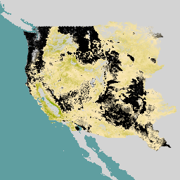
'RCMAP (Rangeland Condition Monitoring Assessment and Projection) ডেটাসেট ১৯৮৫-২০২৩ সাল পর্যন্ত ল্যান্ডস্যাট চিত্র ব্যবহার করে পশ্চিম উত্তর আমেরিকা জুড়ে রেঞ্জল্যান্ড উপাদানগুলির শতাংশ কভার পরিমাপ করে। RCMAP পণ্য স্যুটটিতে দশটি ভগ্নাংশ উপাদান রয়েছে: বার্ষিক ভেষজ, খালি জমি, ভেষজ, লিটার, নন-সেজব্রাশ গুল্ম, বহুবর্ষজীবী ভেষজ, সেজব্রাশ, ... জলবায়ু পরিবর্তনের ব্যাঘাত ল্যান্ডস্যাট-উদ্ভূত ল্যান্ডইউজ-ল্যান্ডকভার এনএলসিডি রেঞ্জল্যান্ড কম্পোনেন্ট টাইমসিরিজের জন্য RCMAP রেঞ্জল্যান্ড ট্রেন্ডস ইয়ার (১৯৮৫-২০২৩), v০৬ 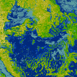
এই সংগ্রহে ১৯৮৫ থেকে ২০২৩ সাল পর্যন্ত RCMAP বার্ষিক পণ্য অন্তর্ভুক্ত রয়েছে। RCMAP (Rangeland Condition Monitoring Assessment and Projection) ডেটাসেট ১৯৮৫-২০২৩ সাল পর্যন্ত Landsat চিত্র ব্যবহার করে পশ্চিম উত্তর আমেরিকা জুড়ে রেঞ্জল্যান্ড উপাদানগুলির শতাংশ কভার পরিমাপ করে। RCMAP পণ্য স্যুটটিতে দশটি ভগ্নাংশ উপাদান রয়েছে: বার্ষিক … জলবায়ু পরিবর্তনের ব্যাঘাত ল্যান্ডস্যাট-উদ্ভূত ল্যান্ডইউজ-ল্যান্ডকভার এনএলসিডি রেঞ্জল্যান্ড কম্পোনেন্ট টাইমসিরিজের জন্য RCMAP রেঞ্জল্যান্ড ট্রেন্ডস (১৯৮৫-২০২৩), v০৬ 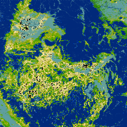
RCMAP (Rangeland Condition Monitoring Assessment and Projection) ডেটাসেট ১৯৮৫-২০২৩ সাল পর্যন্ত ল্যান্ডস্যাট চিত্র ব্যবহার করে পশ্চিম উত্তর আমেরিকা জুড়ে রেঞ্জল্যান্ড উপাদানগুলির শতাংশ কভার পরিমাপ করে। RCMAP পণ্য স্যুটটিতে দশটি ভগ্নাংশ উপাদান রয়েছে: বার্ষিক ভেষজ, খালি জমি, ভেষজ, লিটার, নন-সেজব্রাশ গুল্ম, বহুবর্ষজীবী ভেষজ, সেজব্রাশ, … জলবায়ু পরিবর্তনের ব্যাঘাত ল্যান্ডস্যাট-উদ্ভূত ল্যান্ডইউজ-ল্যান্ডকভার এনএলসিডি রেঞ্জল্যান্ড
Datasets tagged nlcd in Earth Engine
[null,null,[],[],[]]