-
CCNL: DMSP-OLS(1992 ~ 2013 年)の整合性のある修正済み夜間照明データセット v1

整合性のある修正済み夜間照明(CCNL)データセットは、国防気象衛星計画(DMSP)の運用ラインスキャン システム(OLS)バージョン 4 の再処理バージョンです。一連の方法を使用して、年間の不整合、飽和、ブルーミング効果の影響を軽減し、データの品質を向上させました。 dmsp eog imagery lights nighttime ols -
DMSP OLS: グローバル放射輝度校正済み夜間照明バージョン 4、国防気象衛星計画運用ラインスキャン システム

国防気象衛星計画(DMSP)の運用ラインスキャン システム(OLS)には、夜間に可視光と近赤外線(VNIR)の放射源を検出する独自の機能があります。このコレクションには、センサーの飽和のないグローバルな夜間照明画像が含まれています。通常、センサーは高ゲイン設定で動作し、 dmsp eog imagery lights nighttime ols -
DMSP OLS: 夜間照明時系列バージョン 4、国防気象衛星計画運用ラインスキャン システム
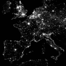
国防気象衛星計画(DMSP)の運用ラインスキャン システム(OLS)には、夜間に可視光と近赤外線(VNIR)の放射源を検出する独自の機能があります。DMSP-OLS 夜間照明時系列バージョン 4 は、利用可能なアーカイブ済み DMSP-OLS スムーズ解像度を使用して作成された雲のない合成画像で構成されています。 dmsp eog imagery lights nighttime ols
Datasets tagged ols in Earth Engine
[null,null,[],[],[]]