পাম তেল বাগানের বিশ্ব মানচিত্র 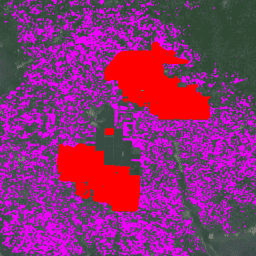
ডেটাসেটটি হলো ২০১৯ সালের একটি ১০ মিটার বৈশ্বিক শিল্প ও ক্ষুদ্র চাষি পাম তেল মানচিত্র। এটি সেইসব এলাকাকে অন্তর্ভুক্ত করে যেখানে পাম তেল বাগান শনাক্ত করা হয়েছে। শ্রেণীবদ্ধ ছবিগুলো সেন্টিনেল-১ এবং সেন্টিনেল-২ এর অর্ধ-বার্ষিক কম্পোজিটের উপর ভিত্তি করে একটি কনভল্যুশনাল নিউরাল নেটওয়ার্কের আউটপুট। অতিরিক্ত তথ্যের জন্য নিবন্ধটি দেখুন… কৃষি জীববৈচিত্র্য সংরক্ষণ ফসল বৈশ্বিক ভূমি ব্যবহার পাম সম্ভাব্যতা মডেল 2025a 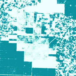
এই চিত্র সংগ্রহটি প্রতি-পিক্সেল ভিত্তিতে একটি আনুমানিক সম্ভাবনা প্রদান করে যে, অন্তর্নিহিত এলাকাটি পণ্য দ্বারা অধিকৃত। এই সম্ভাবনার অনুমানগুলো ১০ মিটার রেজোলিউশনে প্রদান করা হয়েছে এবং একটি মেশিন লার্নিং মডেল দ্বারা তৈরি করা হয়েছে। বিস্তারিত জানতে, ফরেস্ট ডেটা পার্টনারশিপ-এর প্রযুক্তিগত ডকুমেন্টেশন দেখুন… কৃষি জীববৈচিত্র্য সংরক্ষণ ফসল ইইউডিআর বন তথ্য অংশীদারিত্ব পাম সম্ভাব্যতা মডেল 2025b 
এই চিত্র সংগ্রহটি প্রতি-পিক্সেল ভিত্তিতে একটি আনুমানিক সম্ভাবনা প্রদান করে যে, অন্তর্নিহিত এলাকাটি পণ্য দ্বারা অধিকৃত। এই সম্ভাবনার অনুমানগুলো ১০ মিটার রেজোলিউশনে প্রদান করা হয়েছে এবং একটি মেশিন লার্নিং মডেল দ্বারা তৈরি করা হয়েছে। বিস্তারিত জানতে, ফরেস্ট ডেটা পার্টনারশিপ-এর প্রযুক্তিগত ডকুমেন্টেশন দেখুন… কৃষি আলফাআর্থ-উদ্ভূত জীববৈচিত্র্য সংরক্ষণ ফসল ইইউডিআর
Datasets tagged palm in Earth Engine
[null,null,[],[],[]]