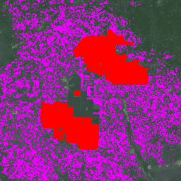
-
팜유 농장 글로벌 지도
이 데이터 세트는 2019년의 10m 글로벌 산업 및 소규모 농가의 팜유 지도입니다. 이 지역에는 팜유 농장이 감지된 지역이 포함됩니다. 분류된 이미지는 Sentinel-1 및 Sentinel-2 반기 합성물을 기반으로 하는 컨볼루션 신경망의 출력입니다. 자세한 내용은 도움말을 참고하세요. 농업 생물다양성 보존 작물 전 세계 토지 사용 -
Palm 확률 모델 2025a
참고: 이 데이터 세트는 아직 동료 검토를 거치지 않았습니다. 자세한 내용은 이 GitHub 리드미를 참고하세요. 이 이미지 모음은 기본 영역이 상품으로 채워질 확률을 픽셀당 추정하여 제공합니다. 확률 추정치는 10m 해상도로 제공되며 … 농업 생물다양성 보존 작물 eudr forestdatapartnership
Datasets tagged palm in Earth Engine
[null,null,[],[[["\u003cp\u003eThe "Global Map of Oil Palm Plantations" dataset provides a 10m resolution global map highlighting industrial and smallholder oil palm plantations for 2019, based on Sentinel-1 and Sentinel-2 data.\u003c/p\u003e\n"],["\u003cp\u003eThe "Palm Probability model 2024a" offers a 10m resolution, per-pixel probability of palm presence, but is not yet peer-reviewed and should be used with caution, referencing its GitHub README for details.\u003c/p\u003e\n"]]],[],null,["# Datasets tagged palm in Earth Engine\n\n-\n\n |---------------------------------------------------------------------------------------------------------------------------------------------------------------------------------------------------------------------------------------------------------------------------------------------------------------|\n | [### Global Map of Oil Palm Plantations](/earth-engine/datasets/catalog/BIOPAMA_GlobalOilPalm_v1) |\n | The dataset is a 10m global industrial and smallholder oil palm map for 2019. It covers areas where oil palm plantations were detected. The classified images are the output of a convolutional neural network based on Sentinel-1 and Sentinel-2 half-year composites. See article for additional ... |\n | [agriculture](/earth-engine/datasets/tags/agriculture) [biodiversity](/earth-engine/datasets/tags/biodiversity) [conservation](/earth-engine/datasets/tags/conservation) [crop](/earth-engine/datasets/tags/crop) [global](/earth-engine/datasets/tags/global) [landuse](/earth-engine/datasets/tags/landuse) |\n\n-\n\n |---------------------------------------------------------------------------------------------------------------------------------------------------------------------------------------------------------------------------------------------------------------------------------------------------------------------------------------|\n | [### Palm Probability model 2025a](/earth-engine/datasets/catalog/projects_forestdatapartnership_assets_palm_model_2025a) |\n | Note: This dataset is not yet peer-reviewed. Please see this GitHub README for more information. This image collection provides estimated per-pixel probability that the underlying area is occupied by the commodity. The probability estimates are provided at 10 meter resolution, and have been generated by ... |\n | [agriculture](/earth-engine/datasets/tags/agriculture) [biodiversity](/earth-engine/datasets/tags/biodiversity) [conservation](/earth-engine/datasets/tags/conservation) [crop](/earth-engine/datasets/tags/crop) [eudr](/earth-engine/datasets/tags/eudr) [forestdatapartnership](/earth-engine/datasets/tags/forestdatapartnership) |"]]