-
코코아 확률 모델 2025a
참고: 이 데이터 세트는 아직 동료 검토를 거치지 않았습니다. 자세한 내용은 이 GitHub README를 참고하세요. 이 이미지 컬렉션은 기본 영역이 상품으로 점유될 확률을 픽셀당 추정치로 제공합니다. 확률 추정치는 10m 해상도로 제공되며 …에서 생성되었습니다. 농업 생물 다양성 보존 작물 eudr forestdatapartnership -
커피 확률 모델 2025a

참고: 이 데이터 세트는 아직 동료 검토를 거치지 않았습니다. 자세한 내용은 이 GitHub README를 참고하세요. 이 이미지 컬렉션은 기본 영역이 상품으로 점유될 확률을 픽셀당 추정치로 제공합니다. 확률 추정치는 10m 해상도로 제공되며 …에서 생성되었습니다. 농업 생물 다양성 보존 작물 eudr forestdatapartnership -
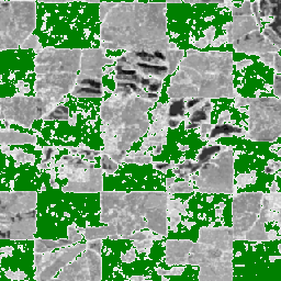
EC JRC 전 세계 산림 피복 지도 2020, V3

전 세계 산림 피복 지도는 2020년의 산림 존재 및 부재를 10m 공간 해상도로 명시한 공간 데이터로 제공합니다. 2020년은 유럽 연합의 '…에 제공되는 규정'의 기준일에 해당합니다. eudr forest forest-biomass jrc -
EC JRC 전 세계 산림 유형 지도 2020, V1

전 세계 산림 유형 지도는 2020년의 원시림, 자연 재생림, 식재림 (조림지 포함)을 10m 공간 해상도로 명시한 공간 데이터로 제공합니다. 이러한 산림 유형을 매핑하기 위한 기본 레이어는 산림 피복 범위입니다. eudr forest forest-biomass jrc landcover primary-forest -
산림 지속성 v0
참고: 이 데이터 세트는 아직 동료 검토를 거치지 않았습니다. 자세한 내용은 이 모델과 연결된 GitHub README를 참고하세요. 이 이미지는 픽셀 영역이 2020년에 방해받지 않은 산림으로 점유되는지 여부를 나타내는 픽셀당 점수([0, 1] 범위)를 제공합니다. 이러한 점수는 … 생물 다양성 보존 산림파괴 eudr forest-biomass forestdatapartnership -
2020년 전 세계 천연림

2020년 전 세계 천연림은 2020년의 전 세계 천연림 확률 지도를 10m 해상도로 제공합니다. 이 지도는 유럽 연합의 산림파괴 규정 (EUDR)과 같은 이니셔티브 및 산림 보존과 모니터링을 위한 기타 노력을 지원하기 위해 개발되었습니다. 지도 … 생물 다양성 기후 보존 산림파괴 eudr forest -
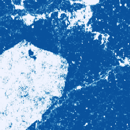
팜 확률 모델 2025a

참고: 이 데이터 세트는 아직 동료 검토를 거치지 않았습니다. 자세한 내용은 이 GitHub README를 참고하세요. 이 이미지 컬렉션은 기본 영역이 상품으로 점유될 확률을 픽셀당 추정치로 제공합니다. 확률 추정치는 10m 해상도로 제공되며 …에서 생성되었습니다. 농업 생물 다양성 보존 작물 eudr forestdatapartnership -
고무나무 확률 모델 2025a

참고: 이 데이터 세트는 아직 동료 검토를 거치지 않았습니다. 자세한 내용은 이 GitHub README를 참고하세요. 이 이미지 컬렉션은 기본 영역이 상품으로 점유될 확률을 픽셀당 추정치로 제공합니다. 확률 추정치는 10m 해상도로 제공되며 …에서 생성되었습니다. 농업 생물 다양성 보존 작물 eudr forestdatapartnership
Datasets tagged eudr in Earth Engine
[null,null,[],[],["Multiple datasets offer 10m resolution spatial data. Two datasets map global forest cover and types for 2020, distinguishing between primary, naturally regenerating, and planted forests. Three other datasets provide per-pixel probability estimates for cocoa, palm, and rubber tree presence. Finally, one dataset quantifies the likelihood of undisturbed forest in 2020. These probability models are marked as pre-peer review. All of them are made for the regulation from the European Union.\n"]]